Cape Conran Coastal Park (Marlo)

")
Cape Conran Coastal Park near Marlo in East Gippsland has heathlands, wild ocean beaches and banksia woodlands brimming with nectar-feeding birds.
A great park for water activities - enjoy swimming, diving, boating, fishing or rock pooling. Experience the park by foot on the self-guided Cape Conran Nature Trail or the magnificent Dock Inlet and Pearl Point day walks.
Popular Things to do
Walks
Some of the more popular beach walks are around Cape Conran itself. The day visitor areas on the east and west sides of the Cape provide easy access to the beach.
From West Cape beach you can stroll up to Conran Creek or keep going the seven kilometres to Point Ricardo which takes approximately three hours one way. Along the East Cape you can walk up the beach to the Yeerung River which takes approximately one and a half hours one way. From here you can keep walking to Dock Inlet or Pearl Point.
Pearl Point features spectacular sedimentary rock formations, rolling sand dunes and an abundance of seabirds and sea life. It is a popular sport for surf fishing. There is a walk from East Cape to Pearl Point (25km return). This walk is only for the more energetic as it can be a difficult due to the soft beach sand.
Dock Inlet is a unique land locked expanse of fresh water isolated from the coast by a coastal dune barrier. The inlet is fed by the east and west branches of Dock Creek from a pristine catchment. The shallow tannin coloured waters support a diverse range of waterfowl.
Keep an eye out for White-bellied Sea Eagles that are often seen in the area.
Walking to Dock Inlet (14 km, 5 - 6 hours return from the Yeerung River)
Along the East Cape you can walk up the beach to the Yeerung River which takes approximately one and a half hours one way. From here you can keep walking to Dock Inlet or Pearl Point. Follow the posts set in the dunes from the beach or signs on the Powerline Track. This walk can also be a return walk via the Powerline Track and the Yeerung River.
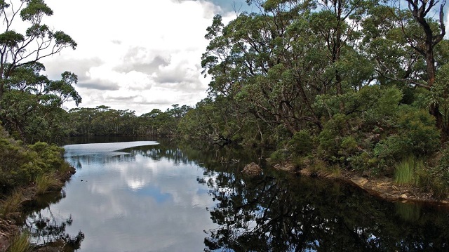
Yeerung River - Experience the rich diversity of flora and fauna which is found in the lower reaches of the Yeerung River. A different perspective to the river is especially noticeable at sunset and sunrise when the birds are at their most active and the water is often calm and reflections clear.
A good way to explore this area is by walking along the Estuary View Trail (1.5 km, 1 hour return). The track also allows access to the coastline east of the river when the entrance is breached.
Yeerung Gorge - a jewel on the Cape - is a surprising landform that harbours some unusual vegetation associations and contains several deep dark rock pools fed by the babbling East Yeerung River.
You can reach the gorge, which is deeply incised into the coastal plain, by crossing the Yeerung Bridge and taking the Powerline Track and the East Yeerung Track to the carpark. The walk is 0.6 km, 20 mins one way from East Yeerung Track Carpark.
Heathland Walk (1 km, 1 - 1.5 hours return)
The Heathland Walk starts near the Activities Centre opposite the office on the west side of the camp road. A walk through the heathland can be full of surprises. Many birds feed on the nectar rich plants and occasionally the threatened Ground Parrot (Pezoporus wallicus wallicus) may be sighted. Whilst in flower the striking spikes of Grass Trees provide a post for the rosellas to feed from. Lizards and large Lace Monitors, (known as Goannas) are common around Cape Conran.
East Cape Boardwalk (0.6 km, 1 - 1.5 hours return)
Cape Conran is rich in cultural heritage, both Indigenous and post European. The East Cape Boardwalk was a joint project of the then National Parks Service and the Moogji Aboriginal Council in Orbost. The boardwalk rounds the East Cape to Cowrie Bay. Along the way interpretive signs give you a glimpse of the uses Indigenous people made of the many resources around the Cape. The boardwalk joins the Nature Trail and a complete loop can be made back to the East Cape Day Visitor Area, or continue on to the West Cape and Salmon Rocks Beach. The Salmon Rocks lookout is part of the Batuluk Cultural Trail and has information on Indigenous midden sites.
Nature Trail (1.5 kms, 1.5 - 2 hours return via boardwalk)
The Cape Conran Nature Trail begins in the East Cape Day Visitor Area and continues across the Cape to the western side. The Nature Trail provides insight into the special nature of the coastal environment. From Joiners Channel and the boat ramp there are trails round to Salmon Rocks Beach.
Camping Facilities
Cape Conran has relaxed bush camping among mahogany gums in a banksia woodland. Fireplaces, picnic shelter, bush showers and septic toilets are provided in the Banksia Bluff camp area. Borewater is available, but is not recommended for drinking. The nearest food supplies are at Marlo. Gas, wood, ice and a public phone is available from the Manager's office.
Location and Access
Cape Conran Coastal Park in Far East Gippsland is located approximately 420 km east of Melbourne and 530 km south of Sydney. Cape Conran can be reached via the Princes Highway by turning off at Cabbage Tree Creek or via Orbost and Marlo to the west. The eastern section of the park can be reached by turning off the highway east of Cabbage Tree Creek to Bemm River.
Note: Photos from Parks Victoria
Location
Yeerung Road, Marlo 3888 Map
Web Links
→ Cape Conran Coastal Park (Parks Victoria)
→ Cape Conran Coastal Park on Facebook
→ Cape Conran Coastal Park - Park note (PDF)
")


")