Balook - Tarra Bulga National Park


Hidden within the Strzelecki Ranges, Tarra Bulga National Park features lush fern-filled gullies, giant Mountain Ash and ancient Myrtle Beech. Visitors have long enjoyed strolling along one of the nature walks or picnicking beside a shady fern-lined creek.
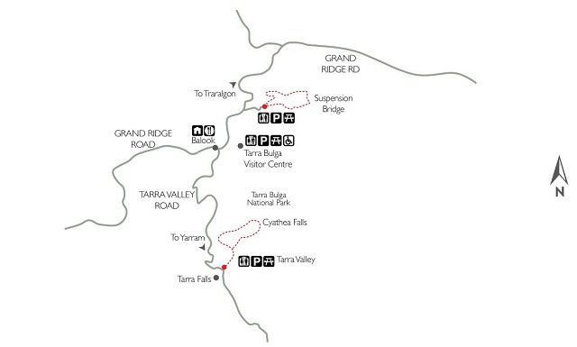
Tarra-Bulga National Park, situated at the eastern end of the Grand Ridge Road, offers visitors several short walks through rainforest gullies and Mountain Ash forest. In addition there are some longer walks for more experienced walkers looking for a greater challenge including to the Corrigan Suspension Bridge and Cyathea Falls from the Visitor Centre.
Enjoying the Park
Picnicking
Tarra-Bulga National Park is a delightful setting for a picnic. Three picnic areas are situated within the park; at the Visitor Information Centre, Tarra Valley and Bulga. The Visitor Centre picnic area provides picnic tables, electric barbeques, a picnic shelter and toilets with disabled access.
Tarra Valley and Bulga picnic areas are set amongst the Giant Mountain Ash and shady fronds of tree ferns. Tables, toilets and picnic shelters are provided.
Accommodation
Camping is not permitted within the park. Caravan parks are situated within the Tarra Valley and in Yarram and Traralgon. Other accommodation including guesthouses and bed and breakfasts are scattered throughout the Strzelecki Ranges.
Walking
Walks from the Visitor Centre include:
1. Corrigan Suspension Bridge (1.2 km, 25 min one way)
Walk to the impressive Corrigan Suspension Bridge, which stretches through the rainforest canopy, affording spectacular views of the lush fern gully on the forest floor below. Follow the signs from the Visitor Centre Carpark via Lyrebird Ridge, Ash and Wills Tracks.
2. Lyrebird Ridge Track (2.4 km, 45 min return)
Commencing at the Visitor Information Centre, this track leads through regenerating and mature Mountain Ash forests. Rest on the seats provided and listen to the sounds of the forest.
3. Forest Track (4.4 km, 1.5 hours return)
Starting at the end of the Lyrebird Ridge Track, this longer walk completes a circuit back to the Visitor Centre via part of the Old Yarram - Balook Road. This track winds its way through Mountain Ash forest, a rainforest gully and an unusual thicket of Hazel omaderris. This track contains some steeper sections, is unsurfaced and is recommended for the more serious walker.
4. Ash Track (680 metres, 12 min one way)
Branching off the Lyrebird Ridge Track, this track leads through regenerating Mountain Ash forest to the beginning of the Fern Gully Nature Walk. Look for remnants of logging that occurred here in the early 1900s. Eucalypts are now growing to replace them.
5. Fern Gully Nature Walk (720 metres, 15 min return)
The Fern Gully Nature Walk begins where the Ash Track meets the Wills Track and provides an excellent introduction to the plants and wildlife of the Mountain Ash Forests and Cool Temperate Rainforests of the Strzelecki Ranges. Interpretive signs along this track explain the features seen.
6. Scenic Track (1 km, 20 min one way)
This walk takes you through tall Mountain Ash forest and patches of Cool Temperate Rainforest. It commences at the Corrigan's Suspension Bridge and finishes at the Bulga entrance. From here you can continue back to the Visitor Centre or walk down the road to the Bulga Carpark.
Walks from the Tarra Valley Picnic area include:
1. Tarra Valley Rainforest Walk (1.4 km, 35 minutes return)
Meander through a rainforest gully and across trickling mountain streams to Cyathea Falls. The Ancient Myrtle Beech along the trail creates a protective canopy above a delicate understorey of tree ferns, lichens and moss. On the opposite side of the road at the start of the walk is Tarra Falls.
Access for Dogs:
Cats and dogs are not permitted within the park.
History
In 1840 the Polish explorer, 'Count' Strzelecki and his party, explored the ranges that now bear his name. Guided by Aboriginal guide, Charlie Tarra they cut through the thick scrub and tall timber of the Strzelecki Ranges and eventually reached Western Port, wet, hungry and exhausted.
The eastern Strzelecki Ranges were opened for selection from the 1890s and settler's cottages soon dotted the ridges. Farmers had to contend with short milking seasons, cold winters, noxious weeds, thick scrub and extreme transport difficulties.
In 1903 the Alberton Shire Council asked the State Government to reserve an area of forest with fern gullies near Balook as a public park.
Twenty hectares were reserved in 1904 and given the Aboriginal name Bulga, meaning 'mountain'. Five years later, 303 hectares of forest within the Tarra Valley were temporarily reserved. This park was named after Charlie Tarra, Count Strzelecki's Aboriginal guide.
In 1986 the two separate National Parks were joined and enlarged through a land exchange with private industry. Tarra-Bulga National Park now protects over 2,000 hectares of Mountain Ash Forest and Cool Temperate Rainforest.
Location and Access
Tarra Bulga National Park is situated approximately 200 kilometres east of Melbourne. The park is reached from the Princes Highway at Traralgon by following Traralgon Creek Road to Balook. Alternatively the park can be reached from Yarram via the Tarra Valley Road. Roads throughout the area are narrow and winding but offer marvellous scenery with panoramic views from several points, including Mount Tassie.
Note: Photos from Parks Victoria and map from Visit Gippsland
Location
The Grand Ridge Road, Balook 3971 Map
Web Links
→ Tarra Bulga National Park
→ Map - Tarra Bulga National Park
→ Visitor Guide - Tarra Bulga National Park
→ Friends of Tarra Bulga National Park on Facebook
→ Map - Tarra Bulga National Park (East)
→ Map - Tarra Bulga National Park (West)
→ Park Note - Tarra Bulga National Park
→ Heritage Story - Tarra Bulga National Park
")


")