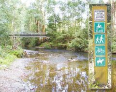
Moe - Tyers Junction Rail Trail


Follow the route of an old government tramway that carried timber out of the Tyers Valley, connecting with the former narrow gauge railway to Walhalla at Collins Siding. Enjoy rainforest, fern gullies, seasonal wildflowers and the adventure of some creek crossings along the way.
While Gippsland's rail trails generally follow the course of the Victoria's abandoned rail lines the Tyers Junction Rail Trail has been established along a timber tramway. The steel railed tramway was laid in the Tyers Valley in 1925 to provide timber mills in the area with more reliable transport for their sawn timber. The tramway closed in 1949 and it has now found new life as the Tyers Junction Rail Trail. The trail passes through rainforest, fern gullies, messmate and stringy bark forest, and there are plenty of birds, mammals and seasonal wildflowers. Expect fallen trees across the trail and watch out for snakes in the summer.
Summary:
Distance: 11 km (22 km return)
Start Point: 30km north of Moe
Start/end: Moe-Erica Road, Collins Siding to Tyers Junction
Track: Rough dirt track
Grade: Level 3 - Challenging rides requiring experience and a good level of fitness
Note: This is definitely a mountain bike ride made up of generally smooth, gradual climbs and descents, with some creek crossings. Caringal Scout Camp is the turnaround point. Take care at the creek crossings that can be wet and muddy.
Getting there: Travel via Monash Freeway (M1) and Princes Highway (A1) to the Moe turn off approximately 130km east of Melbourne and follow the signs to Walhalla along the Moe-Erica Road. The trail starts just past Telbit Road, approximately 28km after the roundabout at the north end of Moe. Park in the clearing just past the fence line of the house on the left.
Location
Moe-Erica Road, Moe 3825 Map
Web Links
→ Tyers Junction Rail Trail (railtrails.org.au)


