Lerderderg State Park (Darley)

")
Lerderderg State Park comprises 20,546 hectares and stretches some 20 km between Bacchus Marsh and Blackwood. Rising in the Great Dividing Range, the Lerderderg River has cut a 300 metre deep gorge through sandstone and slate, almost bisecting the park. The park has a wide variety of vegetation and wildlife and some interesting relics of goldmining.
Things to Do
- Lerderderg State Park offers a true bush experience. Walking is the best way to get to know the park - there are several tracks for a range of walks from short, easy strolls to strenuous overnight hikes for experienced bushwalkers.
- Other activities include camping, swimming, rock-climbing, fishing and scenic driving, although some tracks may be closed in winter and early spring.
- The river is popular with anglers. Blackfish and Brown Trout are the most commonly caught fish.
Facilities
- There are picnic areas with fireplaces at O'Brien's Crossing, Shaw's Lake and Mackenzie's Flat (electric barbecues).
- Be self-sufficient with drinking water. Carry it in and/or know how to make untreated water safe for drinking.
Heritage
The gorge represents 500 million years of geological history. The river and lesser streams have eroded strata dating back to the Ordovician period. The area was mined during the gold rush and the remains of water races used for washing gold can still be seen upstream from O'Brien's Crossing. A tunnel dug to divert the river to expose its bed also remains.
Fauna
This park is important for wildlife. Koalas live in the manna gums. Eastern Grey Kangaroos, Swamp Wallabies and Spiny Ant-eaters are also about during the day. Nocturnal animals include the Greater Glider, Bobuck (or Mountain Brushtail Possum), Bent wing Bat and Powerful Owl.
There are wonderful birdwatching opportunities. Sulphur-crested Cockatoos nest in the gorge and fly out to feed in the open grasslands. They are sometimes preyed on by the area's most spectacular predator, the Wedge-tailed Eagle which nests in tall trees in the side gulleys. Other birds to be seen are the White-naped Honeyeaters, White-throated Treecreepers, Crimson Rosellas and Gang-gang Cockatoos can be located by the noise of cracking eucalyptus nuts.
Vegetation
Vegetation throughout the park varies substantially. There is a striking transition of vegetation following a rainfall gradient from south to north. Dry stringybark-Box forests near the gorge mouth and Box-Ironbark woodlands along the high ridges of the south, grade into taller, damper Messmate-Peppermint- Gum forests along the northern boundary along the northern boundary of the park. Along the river beds are Blue Gums and Manna Gums; grevilleas, wattles and hakeas cover the cliffs. Late winter and spring is the best time to see this shrubbery in bloom as well as spectacular displays of wildflower.
Precautions
- After heavy rain the river can rise suddenly - consider this aspect if attempting overnight walks, especially when following the river.
- Many tracks are suitable only for four wheel driving and in dry weather.
- Emergency markers are currently installed in locations around in this park.
How to Get There
Take the Western Freeway and approach the park via:
- Greendale-Trentham Road and O'Brien's Road for O'Brien's Crossing.
- Bacchus Marsh-Gisborne Road and Lerderderg Gorge Road for Mackenzie's Flat picnic area.
- Blackwood, then Golden Point Road for Shaw's Lake.
Opening Hours:
Access available at all times.
Access for Dogs:
Dogs on a leash are permitted in some areas of the park, but are prohibited within the Conservation Zone, Reference Area Zone, Mackenzies Flat Picnic Area and the walking track from Mackenzies Flat Picnic Area to Grahams Dam.
Swimming:
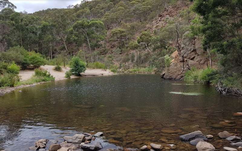
At Mackenzies Flat Picnic Area there are some shallows where kids can play. Along the river there are some stepping stone river crossings and when you reach Grahams Dam there is deeper water to swim in. The water is usually clear but can dry up late in the summer during dry periods.
Review:
We went for a walk along the Lerderderg River from Mackenzies Flat Picnic Area. It is a 1.6km return walk to Grahams Dam. This is a fun walk because the river is generally very low and you can jump across rocks to cross the river in a number of places. The trail requires a minimum of at least one crossing. However, if there has been rain recently expect to get wet shoes or plan on walking across the river in bare feet.
The trail goes along some "cliffs" but they are not too scary for the kids (provided they don't get too close to the edge). It is interesting to be in a gorge with walls on each side. There is also plenty of fun to be had skipping stones across the water and throwing rocks into the river. There are some excellent longer walks in the north west near Blackwood.
Photos:
Location
Lerderderg Gorge Road, Darley 3340 Map
Web Links
→ Lerderderg State Park (Parks Victoria)
→ Lerderderg State Park - Park Note (PDF)
→ Lerderderg State Park Pyrete Range - Park Note (PDF)
→ Lerderderg State Park - Map (PDF)
→ Lerderderg State Park Pyrete Range - Map (PDF)
")


")