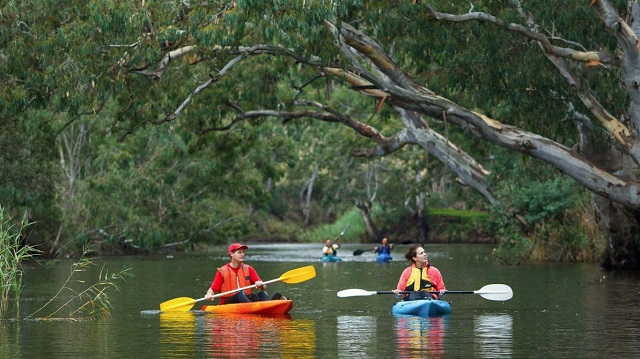
Maribyrnong River (Maribyrnong)


The Maribyrnong River, which begins on the slopes of Mount Macedon and flows to Port Phillip, has played a major role in the occupation and development of western Victoria. Aboriginal tribes have frequented its banks for at least 40,000 years. The river has been part of the rapid developments that have occurred in the last 50 years. The river was known as Saltwater River before its present name came into common usage.
Things to Do
- Most people will first meet the Maribyrnong River at Keilor where a bend almost circles Horseshoe Bend Farm and a wider sweep rings the main Brimbank Park.
- These waters provide good canoeing and three ponding points have been designed to enable children and adults to discover the delights of catching fish with a hand net.
- The park has barbecues, picnic tables and shelters, and a shared cycle/walking path starts in the park and continues on to Footscray.
- Very little remains of the Riverview Teagardens near Canning Reserve. Here the ladies would be brought up the river for an afternoon of dancing and dining. Today, there is a boat landing at Canning Reserve.
- An unspoilt section of the river takes a wide sweep around the Department of Defence land with its remains of the Explosive Factory.
- Parklands on either side of the river include Maribyrnong Park and Fairbairn Park where there are boat landings and picnic facilities.
- Pipemakers Park can be reached from the river and is worth a visit. This is the site of a former meat canning works and later a pipe factory, and pamphlets enable visitors to undertake a self guided tour through the historic ruins.
- The river flows past Footscray Park with its Scotchman's Hill from where the famous Melbourne Cup can be glimpsed at Flemington Racecourse on the opposite side of the river.
- Just downstream from Dynon Road Bridge it is possible to board a pleasure boat for a leisurely trip up the river. From here on the river passes through the industrial area of Footscray with its historic jetties and bridges before it joins the Yarra at Fishermans Bend.
- Fishing is popular from jetties and fishing platforms alongside parks and reserves on either side of the river.
Facilities
- Maribyrnong Valley is a popular destination for a wide range of people.
Bicycle tracks follow its banks, crossing the river via pedestrian bridges at several points. - Many people use these trails to get to Brimbank Park or Pipemakers Park.
- Boat landings: Henderson House Landing, Footscray; Footscray Wharf; Lynch's Bridge Jetty, Kensington; Flemington Racecourse Jetty, Flemington; Fairbairn Park Jetty, Ascot Vale; Marbyrnong Park Landing, Moonee Ponds; Henley Landing, Moonee Ponds; Footscray Park Jetty, Footscray; Canning Reserve, Avondale Heights; and Pipemakers Park, Maidstone.
- Fishing Platforms: Newell's Paddock Reserve; Footscray Park and Maribyrnong Boulevarde; Fairbairn Park; Maribyrnong Park; Aberfeldie Park; Riverside Park, Footscray; Pipemakers Park, Maribyrnong; Brimbank Park.
Heritage
Some of Australia's most important Aboriginal archaeological sites are located in the Maribyrnong River Valley. In 1940, a 15,000 year old Aboriginal skull was found during excavation of a sand pit, on Dry Creek near the Maribyrnong River in Keilor. Further investigations have unearthed evidence of campsites which formed part of one of the oldest human habitations in Australia.
Charles Grimes and James Fleming surveyed the river in the early 1800s. Later, the Gold Rush brought an influx of people to Melbourne with subsequent pollution of the river.
Commercial passenger boats began operating along the Maribyrnong in 1896, and the Wine Hall, which served local wines and other refreshments to picnickers and boaters, hit its heyday in 1906 when trams from Flemington Bridge linked with boats at the Anglers Arms Hotel.
Nearby, the Riverview Teagardens began operation in 1909. The gardens were elaborate, with sportsgrounds, kiosks, a dance hall and aviaries. The gardens and associated pleasure cruises were very popular in the 1920s and 30s. They closed during the war and did not regain their popularity afterwards.
The Living Museum of the West at Pipemakers Park has a great deal of pictorial and printed information on the history of the Maribyrnong River Valley.
Vegetation
Some of the parks such as Footscray Park, Maribyrnong Park and nearby reserves have been planted out with exotic trees, while at Brimbank Park the native grasses can be seen along the river. Upstream, the rich river flats on the east bank were used for market gardening until 1983.
How to Get There
The Maribyrnong River Trail mainly follows the river bank, sometimes both banks, with occasional links along quiet side streets. It runs 23 km from Footscray to Keilor's Brimbank Park.
The river can be accessed from: Footscray Park, near Ballarat Road; Fairbairn Park at Newsom Street; and Riverside Park, The Boulevarde.
For the southern section: enter parkland off Buckley Street via either Lily Street or Riviera Road, at Canning Reserve (Old Canning Street) or Grimes Flat, White Street or Rhonda Street.
On the west bank, access the river from: Pipemakers Park, Van Ness Avenue or Cranwell Park Reserve, Cranwell Street.
Location
Van Ness Avenue, Maribyrnong 3032 View Map
Web Links
→ Maribyrnong River (Parks Victoria)
→ Maribyrnong River Visitors Guide (Doc)
→ The Friends of the Maribyrnong Valley
→ Recreational Boating Guide - Yarra & Maribyrnong Rivers (PDF)


