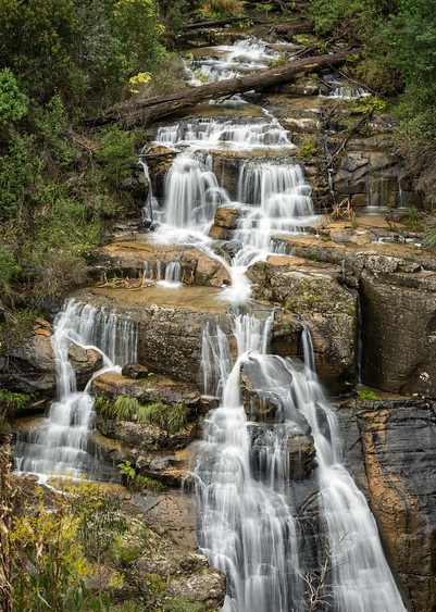
Kinglake National Park


Only 65 km north of Melbourne, this 22,360 hectare park lies on the slopes of the Great Dividing Range. Scenic lookouts offer dramatic views of the Melbourne skyline, Port Phillip Bay, the Yarra Valley and across to the You Yangs. Forests, fern gullies and waterfalls are among the other attractions.
Things to Do
- Tracks throughout the park enable you to plan a variety of short and long walks.
- The Lyrebird Track near the Masons Falls Picnic Area is suitable for people with limited mobility.
- Visit Masons Falls, and the interpretive display in the Visitor Centre (western section).
- Enjoy the wildflowers in spring and the views from the Mount Everard Track in the Jehosaphat Gully (eastern) section.
- Walk to Wombelano Falls in the Wombelano-Andrews Hill (northern) section.
Facilities
- Masons Falls - sheltered picnic tables, gas barbecues, toilets with disabled access and parking at the picnic area. A car park and picnic tables are provided at Mount Sugarloaf.
- Jehosaphat Gully - tables, electric barbecues and toilets. Island Creek picnic area has picnic tables, fireplaces and toilets.
Heritage
The Great Dividing Range was the boundary between the Wurundjeri people to the south and the Taunerong people to the north. Aboriginal people had an intimate knowledge of the geography, flora and fauna of the country.
European settlers entered the Kinglake area in the hope of striking it rich. Shafts and diggings around the park are evidence of the gold mining days, but the gold fields were not very rich and soon timber cutting replaced mining in importance. By the 1920s the accessible timber supply was running out and potatoes and berry fruits became the principal products.
Agriculture brought large-scale clearing - seen by several prominent local people as a threat to the natural values of the area - so Kinglake National Park was created in 1928. Kinglake was popular for picnics, honeymoons and other outings in the 1920s and 30s. (The area was named after the celebrated English author and lawyer, Alexander William Kinglake). Since then the park has grown through land donations and acquisitions.
Fauna
You may see a Black Wallaby, Platypus, Wedge-tailed eagle and a variety of small birds especially in the Masons Falls area. Superb Lyrebirds, rosellas and kookaburras can also be seen in the Jehosaphat Gully and Masons Falls picnic areas, and there are many other fauna species throughout the park
Vegetation
Fern gullies are a feature of many walks in Kinglake National Park.
In the Masons Falls area, there is a variety of vegetation including Messmate forest with bracken under-storey, open grassy areas, Austral Grass-trees, ferns, and Hazel Pomaderris. Spring brings a carpet of wildflowers including orchids, lilies, everlasting daisies, correas, grevillea and heath.
Bushwalks from Jehosaphat Gully pass through both wet and dry forest and lush fern gullies, banksia and grass trees. Wildflowers are abundant along the Mount Everard track in spring.
Shallow soil and drier conditions create a less towering, more open forest in the Wombelano-Andrews Hill section.
How to Get There
Mount Sugarloaf section: National Park Road, Pheasant Creek (Melway KeyMap: 10). Everard section: Kinglake-Healesville Road (Mt Slide Road), Kinglake (Melway KeyMap: 10).
Wombelano section: Glenburn-Eucalyptus Road, Kinglake, and Extons Road, Kinglake Central (Melway KeyMap: 10).
Opening Hours
Dependant on area.
Access for Dogs:
Dogs are not allowed in Kinglake National Park.
Location
Mt Slide Road, Kinglake 3763 View Map
Web Links
→ Kinglake National Park (Parks Victoria)
→ Kinglake National Park Visitor Guide (PDF)
→ The Best Family Activities in the Yarra Valley
→ Kinglake National Park Heritage Story (PDF)
→ Kinglake National Park Map (PDF)


