Valley Reserve (Mount Waverley)

.jpg "Valley Reserve (Mount Waverley)")
Valley Reserve is one of the few remaining intact native bushlands in Monash. The reserve is 15 hectares which is approximately the same size as 6 Melbourne Cricket Grounds (MCGs) or 18 soccer fields.
The flora and fauna (plants and animals) found at Valley Reserve were once widespread. Now Valley Reserve is one of the last places to find many native species within Melbourne. Valley Reserve is located adjacent to Scotchmans Creek, providing an important habitat corridor for native animals.
There are a number of interconnecting trails through the reserve including the Valley Loop Track, Stringybark Track across the north and Woodland Track cutting across the creek. There is a map at the main car park.
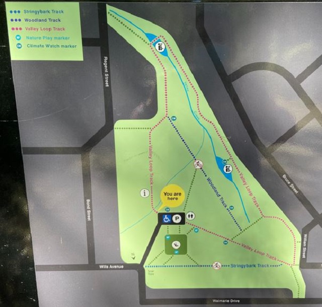
Valley Loop Track - Experience the diversity of plants and animals within the reserve.
Distance: 1700 metres
Time: 20 to 30 minutes
Grade: Suitable to prams (some moderate slopes).
Woodland Track - Be immersed in the Valley bushland, which includes a special section of remnant vegetation.
Distance: 400 metre
Time: 10 to 20 minutes
Grade: Not suitable for prams and bikes.
Stringybark Track - Crossing Valley Reserve from east to west, the Stringybark Track includes an Indigenous scar tree.
Distance: 400 metres
Time: 5 to 10 minutes
Grade: Not suitable for prams and bikes.
Valley Creek flows through Valley Reserve into Scotchman's Creek and then into Gardiner's Creek. It then flows into the Yarra River and into Port Phillip Bay. Valley Creek supports a diversity of habitats including channels and ponds. These habitats support the Nationally Significant Growling Grass Frog, the Regionally Significant Rakali (Native Water-rat) and the Eastern Long-necked Turtle. Within Valley Reserve, sections have been altered by channelling and underground pipelines. Other areas provide wetlands with viewing platforms and boardwalks to experience the wildlife.
When it rains, water flows into stormwater drains and then into creeks and eventually into Port Phillip Bay. As the rain travels across all the urban surfaces, it picks up a lot of nasty pollutants. Help keep all our creeks and beaches clean by making sure the only thing that goes down the drain is rain.
Indigenous History
It is likely that areas associated with water bodies and wetlands were the focus of use by Aboriginal people within and near the City of Monash.
Campsites would have been situated on elevated dry and sheltered ground adjacent to Dandenong, Scotchmans, Gardiners and Damper Creeks. The creeks were not only important sources of fresh water, but also of aquatic animals, such as fish, eels, crustaceans and waterfowl. Plants found along and within creeks, such as reeds and rushes, provided both food and fibre.
The forest provided habitat for a number of land and arboreal (tree dwelling) mammals used for food, sinew, fur and skin, such as possums, kangaroos, wallabies, koalas, emus and echidnas. Swamp, Manna and Red Gum trees were common along watercourses and because of their smooth bark and large size, they were commonly used for the manufacture of bark and wooden implements by Aboriginal people. The scar tree at Valley Reserve is an example of this.
Mapping the Past
The geology of Valley Reserve is highly folded sedimentary Silurian-Devonian bedrock, above which is a layer of mottled orange-yellow clay material from the Brighton Group. Some areas support sandy soil derived from windblown Tertiary sand.
A parish map of c1835-53 shows that the dominant vegetation covering Valley Reserve was Stringybark (Eucalyptus cephalocarpa) woodland, which extended along Scotchmans Creek to the south-western parish boundary.
Sections of Valley Reserve located near the Education Hub were cleared for farming and orchards. Valley Reserve was purchased in 1955 for public open space. The State Government's Interactive Biodiversity Map provides vegetation mapping of pre-1750s (before Europeans) and current vegetation coverage. The vegetation at Valley Reserve is listed as Valley Heathy Forest, Swampy Riparian Complex, and Grassy Forest. When you compare the pre-1750s map with today's vegetation, the Regional Zoological Significance of Valley Reserve becomes very clear. Remnant stands of vegetation can also be found at Damper Creek in Mount Waverley.
Today, the majority of the original vegetation around Valley Reserve has been removed by residential development, wetland drainage and vegetation clearing.
Review:
A lovely reserve to wander around, with the Woodland Track being especially nice. The reserve has a wonderful playground for the kids with a shelter, BBQ, water tap and toilets. The playground has some great sculptures of wildlife - a King Parrot, Yellow-tailed Black Cockatoo, Powerful Owl and Eastern Long-necked Turtle.
The gates to the carpark close at 5pm (Apr - Oct) and 8pm (Nov - Mar).
There are climate watch markers at five locations within the reserve and at the Ted Mason Education Hub there are information panels about the reserve. The tracks are gravel and the reserve is very well sign-posted.
There may be snakes in the area during warmer months.
Access for Dogs:
Dogs must be on lead at all times and there is a signposted area along the Woodland Track where dogs are not permitted.
Photos:
Location
1A Wills Avenue, Mount Waverley 3149 Map
Web Links
→ Valley Reserve Trail Route Details (PDF)
→ scotchmanscreekfriends.org.au
")


")