Maribyrnong River Trail (Keilor East - Footscray)

The Maribyrnong River Trail is a 21km shared use path which follows the Maribyrnong River through the north western suburbs of Melbourne from Brimbank Park.
The path, sometimes along both sides of the river, follows the meandering of the Maribyrnong River through a valley cut in the basaltic plateau in Keilor East at Brimbank Park, then across a floodplain to its entry into the Yarra River at Docklands.
The trail is mostly flat but with does have a fast downhill slope soon after the start. The surface is a mixture of gravel, asphalt and suburban back streets.
Map of trail (route is shown in red)
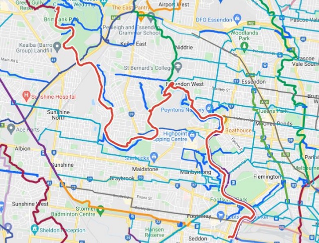
Route description:
Starting at the north end of Brimbank Park in Keilor East which has a lovely play space, the gravel trail winds its way through the trees along the valley on the east side of the Maribyrnong River and the western end of the park. It passes under the towering EJ Whitten Bridge. Near the bridge base a steep path loops up to the same level as the bridge platform, where it connects to the Western Ring Road Trail.
The path then proceeds through riverside parkland alongside suburbs such as North Sunshine and Maidstone before reaching Canning Reserve in Avondale Heights which has a playground.
At Canning Reserve Tea Gardens at Avondale Heights the trail becomes concrete and remains concrete for the next 6 km to Footscray. The path splits into a concrete path that follows a minor creek valley up into Avondale Heights to Monte Carlo Drive Reserve. The main trail, a gravel path, continues along the river. This section of the trail adjoins grassy areas, and sightings of snakes such as the eastern brown snake, on this riverside section of the trail are not uncommon in warmer months.
Near the confluence of Maribyrnong River and Steele Creek at Essendon West the path becomes concrete and follows Steele creek inland before winding up the hillside to the top of the plateau at Lily St for outstanding views of the Maribyrnong River and the skyscrapers of the Melbourne CBD in the distance. Care needs to be taken crossing Buckley Street if turning off to Steele Creek Trail that connects at this point.
The path enters a switch back section that winds back down to the river. Further is Afton Street footbridge across the Maribyrnong River. The trail now runs down both banks of the river. On the northern side at Riverside Park there is a nice playground with a beautifully crafted pirate ship, the "Black Sapphire".
After Riverside Park, the trail passes through Aberfeldie Park and then Maribyrnong Park which has fun playground next to The Boathouse cafe.
At Maribyrnong the path passes through Pipemakers Park with Melbourne's Living Museum of the West, which contains historical presentations on the river valley and the people who have lived there since its initial occupation up to 40,000 years ago by the Wurundjeri people and a excellent playground.
The trail passes Quarry Park which is a fantastic mountain bike park with trails for beginners and intermediates, a skills park and two pump tracks for beginners and intermediate riders.
The path passes Flemington Racecourse, where the Melbourne Cup is run on the first Tuesday of November each year as part of the Spring Racing Carnival, through Footscray Park where there is a nice playground with water play, around the impressive Heavenly Queen Temple and ends near 75 Moreland Street, Footscray.
Location
Brimbank Road, Keilor East 3033 View Map
Web Links
→ Brimbank Park
→ Maribyrnong River Trail (Strava)


")