Maribyrnong River Heritage Trail (Yarraville - Footscary - Maribyrnong)

The Maribyrnong River Heritage Trail tells the story of post-contact early land-use and development along the river. The story begins at the Stony Creek Backwash taking in sites such as the Yarraville Wharf industrial precinct, Barnett Glass Rubber Works, Footscray Wharves, Maribyrnong Railway Bridge, Footscray Park, Jack's Magazine and Pipemaker's Park.
The heritage trail uses the Maribyrnong River as a thread to explore several important themes in the development of Yarraville, Footscray and Maribyrnong. Known as the Saltwater River until 1913, the Maribyrnong marks the eastern and northern boundary of the City of Maribyrnong. From the earliest non-Indigenous settlement in the Melbourne area in the 1830s, its role in the development of Melbourne's west was pivotal. Early crossing places on the river formed the first settled areas of Footscray. The river was a major transport route and a magnet for a range of industries that clustered along the river banks in the second half of the nineteenth century. In turn, these industries offered employment to thousands of workers who made Footscray their home.
For thousands of years before the arrival of non-Indigenous settlers in the 1830s, the Maribyrnong River flowed through land belonging to people of the Woi-wurrung language group. The Marin-balluk clan laid claim to territory to the west of the river, while the Wurundjeri-willam claimed the east. A clan of Boon wurrung speakers, the Yallukit-willam, occupied territory downstream of the rivers junction with the Yarra at Footscray. The river marked the boundary between clans, as well as a route for trade and travel. It was also a source of fish and eels. The two alternative meanings of the word Maribyrnong hint at other food supplies available in the surrounding country. It is thought that it is derived from an Aboriginal phrase, either Mirring-gnai-birr-nong, meaning 'I can hear a ringtail possum' or Mirring-quai-birnong, the name of an edible yam that grew in the river valley.
The first non-Aboriginal people to explore the Maribyrnong arrived in 1803. The New South Wales Governor, Phillip King, had sent a surveying party headed by Charles Grimes, aboard the Cumberland, to watch two French ships exploring Bass Strait. Grimes' party also explored Port Phillip Bay, making landings at several points and rowing up the Maribyrnong River as far as present-day Avondale Heights. Here they noted an Aboriginal fish trap at a 'rock falls' across the river. After Grimes' visit, there were no further intruders into the Maribyrnong region until 1835, when Melbourne was founded. Within a year of John Batman's exploration of land on the shores of Port Phillip Bay, there were 177 people and 26,500 sheep in the Port Phillip District.
From the 1840s, when a slump in Victoria's pastoral industry made it more profitable to boil meat down to make tallow for candles and soap, than sell it for meat or fleece, the Saltwater River began to attract industry. There were slaughtering houses and melting-down establishments at present-day Kensington and, briefly, at Yarraville and then at Maribyrnong. The location of abattoirs at Newmarket attracted associated industries - such as tanners, piggeries, fell-mongerers, soap and candle-makers. In the 1860s and 1870s such industries spread across to the Footscray side of the river. They used the river for transportation of raw materials and produce and as a drain for their refuse. Producers of fertilisers and chemicals followed. By the early twentieth century a series of belching chimney stacks and factories lined the river bank from Dynon Road to Francis St. The factories generated thousands of jobs but gained Footscray the reputation of the smelliest place in Melbourne.
Industrial use of the river for transportation ensured that the Maribyrnong was a busy maritime scene. The Melbourne Harbour Trust was formed in 1877 to manage the Port of Melbourne. Its territory included the Maribyrnong River as far as Footscray. The Trust oversaw the creation of a new course for the Yarra River and the blocking of the old junction between the two rivers near Footscray. It was also responsible for reclaiming land along the banks of the Maribyrnong, for deepening and widening the river to allow vessels to navigate it and for constructing massive wharves at Yarraville and Footscray.
The river and its environs offered work to thousands of people in the nineteenth and twentieth centuries and stimulated the development of Melbourne's west as an industrial centre. It also served as a recreational resource to those who made Footscray their home. Some traces of the river's past can still be glimpsed in sites along this heritage trail. In other places there are but scant reminders of the busy scene that was the Maribyrnong River in the nineteenth and twentieth centuries.
Map of Southern Section
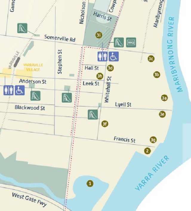
Due to distance Sites 1, 2 and 3 may be more readily accessible by cycling or driving.
1. Stony Creek Backwash
The rare white mangroves thriving at this wetlands site are suggestive of a pristine natural environment. However, they have only been re-established in recent decades. The Stony Creek Backwash is the mouth of Stony Creek which meanders down from Sunshine to enter the Yarra at this point. Layers of human and industrial activity since the 1850s have left their mark on this place, including Australia's worst industrial accident. The Memorial Park, underneath the towering West Gate Bridge, commemorates the 35 workers who died when a span of the bridge collapsed during construction on 15 October 1970.
Melbourne's western region sits on the edge of a vast volcanic basalt plain that extends westward from the Maribyrnong River almost to the South Australian border. Bluestone quarrying, for building and paving purposes, was one of the region's first industries. From the 1850s bluestone was quarried along Stony Creek for use as ballast. Sailing ships arriving in Melbourne carrying imports or passengers, required ballast to weigh them correctly for their return journey to the northern hemisphere. The remnant piles and beams of jetties and wharves in the backwash may have been associated with the ballast trade, which was still being carried on in the 1890s. A wooden drawbridge across the creek at Hyde Street enabled ballast vessels to proceed up and down the creek.
The unidentified wreck in the backwash is believed by some to be a former ballast vessel. However, others believe that it was abandoned here after World War II.
The Mobil Oil Terminal to the north is one of Melbourne's earliest oil terminals. It was initially operated by the Vacuum Oil Company, which established this depot at Yarraville in 1924. Imported oil and kerosene came in by ship to this site and was distributed in cans by rail and road from the depot. Surviving remnants of the railway from the terminal can be seen at Stony Creek Backwash.
In 1949 a new petrol blending unit was installed at Altona. The pipeline seen here connected the Yarraville terminal and oil dock to the Altona refinery. The Holden Oil Dock visible along the banks of the river to the north was opened in 1971.
2. Coode Canal Entrance and Yarraville Wharf Number Six
Dramatic man-made changes to the natural landscape can be seen here, where the Yarra River branches off to the east, marking the entrance to the Coode Canal. The natural course of the Yarra was tortured, often shallow and narrow. Its junction with the Maribyrnong was much further upstream at Footscray. A new course for the river, planned by engineer. John Coode, was constructed in the 1880s. Coode planned to shorten the length of time it took for vessels to reach the city from Hobson's Bay and to excavate large new docks (now called Docklands) adjacent to the Varra on the West Melbourne swampland. The canal rejoined the natural course of the river at West Melbourne. The rock beaching, installed along the Maribyrnong's banks, is another indication of the transformation of the natural state of the river.
To the north of Francis Street, in line with the western river bank, lies Varraville Wharf Number Six, the southernmost of a continuous line of wharves servicing industries along the river. From 1870 a number of industries began to cluster along the banks of the river here at Yarraville. Each of these companies erected their own river wharves. In the 1880s the Melbourne Harbour Trust amalgamated these structures into a continuous line of wharves along the river bank between Francis Street and Somerville Road, though little of the original structure remains.
3. Yarraville Wharf Industrial Precinct
One of the earliest riverside industries at Yarraville was the Joshua Brothers' sugar refinery which began operating in 1873 (3c). Two years later the Victorian Sugar Company purchased the refinery before it merged with refineries in other Australian colonies in 1887, becoming the Colonial Sugar Refinery (CSR). In the late nineteenth century CSR expanded to become a vast industrial complex. It has offered employment to several generations of workers.
In the early years the sugar refinery made use of bones which it obtained from the nearby Macmeikan Bone Mills (3f). The bone mills, which opened in 1870, were the first of a number of fertiliser and chemical manufacturers initially attracted to the Maribyrnong River because of the proximity of abattoirs and sale yards at Newmarket. The river site meant that raw materials could be transported by water to the factories and finished products dispatched by ship to markets. While Macmeikans began producing gelatine, tallow and manure, Robert Smith and Co. established an acid works nearby. In the 1870s James Cuming purchased both of these companies, creating Cuming Smith and Co., (3g), which pioneered superphosphate manufacture in Victoria, producing the famous 'Sickle Brand' of fertiliser and establishing a link between Yarraville and the developing agricultural sector in Victoria. James Cuming became a well-known Yarraville employer and supporter of local causes, residing for a while in the 1880s at Dee Cottage (3e) in Whitehall Street and building a number of other cottages on site for Cuming Smith employees.
Other fertiliser and chemical works such as Wischer and Co. and the Mount Lyell Mining and Railway Company (3b) began operations along the river in Yarraville around the turn of the century. Along with Cuming Smith and Co, these firms were incorporated into Commonwealth Fertilisers in 1929. In 1936 ICI (now Orica) purchased the amalgamated site, selling the former Cuming Smith fertiliser works to a Geelong superphosphate manufacturer, Pivot (3g), but retaining the former Mount Lyell site (3b). The manufacture of phosphates at Varraville was also maintained by the firm of Albright and Wilson (3a), a British firm which joined ICI in a joint venture at Varraville in 1940.
Ned Murphy, who operated several quarries in the local area, used horse teams to transport crushed rock for road-making in the 1860s. From this beginning, the family firm, located in Whitehall Street, began offering transport services to local industries, including CSR from 1917. Although their premises were modified to suit motor transport rather than horses in the 1930s and 194.0s, Murphy's Transport (3d) remains on its original site.
Lying between the Yarraville Wharf Industrial Precinct and the workers' housing to the west, the site of the Varraville Gardens (3h) was reserved for a botanical garden as early as 1859. It was used for quarrying and as a night soil dump during the nineteenth century. In 1913 the Footscray Council began to beautify the site and traces of the Edwardian garden layout are still evident.
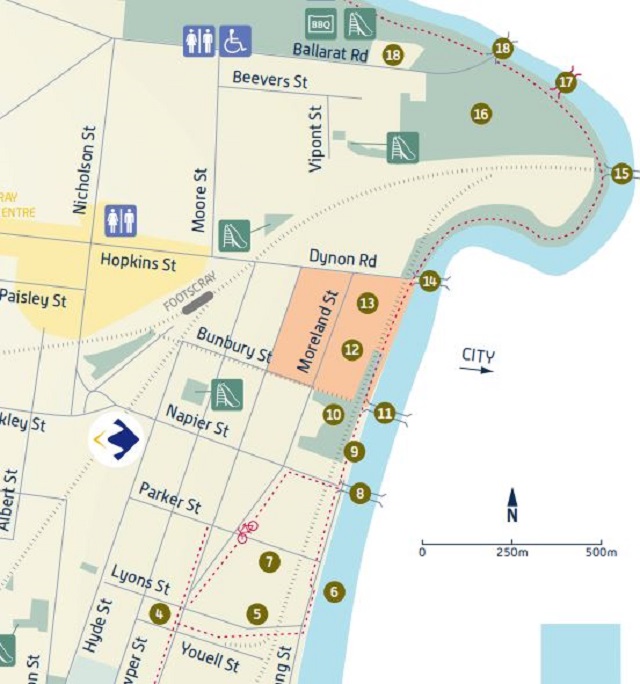
Map of Middle Section
4. Billy Button Creek
Near Corner Lyons Street and Maribyrnong Street, Footscray
The brick-lined drain that empties into the river here follows the course of what was once known as Billy Button Creek. Originating near present-day Albert Street, the creek was the only source of fresh water (apart from tanks) for Footscray residents until 1865, when the town was connected to the Van Yean water supply.
5. Footscray Powder Magazine
If you follow the Billy Button drain back along Lyons Street, you will see a bluestone wall incorporated into a larger industrial complex. This is a remnant from Melbourne's third powder magazine, built in 1857 to store explosives during the gold rush era. Explosives were essential to the mining and quarrying industries and powder magazines were frequently sited close to waterways for safer transportation. A tramway, running parallel to the drain, linked the powder magazine to a small dock on the river. The Footscray Powder Magazine was the first step in a long-lasting link between Footscray and the explosives industry.
The Saltwater River Magazine (site 22) replaced the Footscray Magazine in 1879. When G. Mowling and Sons, manufacturers of soap and candles, moved to Footscray in 1895, they incorporated the old bluestone building into their new factory. Mowling's 1895 buildings can still be seen here on the opposite side of Lyons Street, as part of the Safcol Factory. (5a)
6. Old Course of the Yarra
Opposite Billy Button Creek, on the eastern shore of the river, the remains of an old barge mark the former junction of the Yarra and Maribyrnong Rivers. For some time the barge was thought to be an old hopper barge. However, recent evidence now suggests that it dates from the 1970s. After the formation of the Coode Canal, the old course of the Yarra was reclaimed. The land between the old and new river courses became known as Coode Island.
7. Barnett Glass Rubber Works
The three storey building occupied by Lonely Planet Publishers since 2000, stands where a jute factonj operated in 1875. From 1906 to 1939 the site was used by Barnett Glass Rubber, the first producers of rubber and rubberized clothing in Australia In the 1920s the company employed Joseph Plottel, (also responsible for designing the Footscray Town Hall in Napier Street) to design new buildings, including this one. The expanded site stretched from Maribyrnong Street to Moreland Street. Bradford Cotton Mills purchased the complex in 1939, becoming one of Footscray's largest employers during World War II. The company's name changed to Bradmill Industries in 1968. After Bradmill assumed control of the Davies Coop cotton mills in Yarraville in the late 1970s. operations were gradually transferred to that site. Recent years has seen a transformation of much of the Footscray Complex for a variety of uses including commercial and office use.
8. Shepherd Bridge
In 1839 Port Phillip's first Police Magistrate, Captain William Lonsdale, placed a punt on the Saltwater River at approximately this poinL This was an essential service as the river and the swampy land to the east were formidable barriers on the routes between Melbourne and Williamstown or Geelong. Prior to 1839 the safest river crossing place, a ford near present day Avondale Heights, took travellers several kilometres out of their way.
In the 1880s the Melbourne Harbour Trust reclaimed the West Melbourne swampland before building Footscray Road and a bridge connecting the new road to Footscray. Opened in 1895, the swing bridge rotated around a central pier in the river, allowing vessels to pass through to wharves further upstream. Shepherd Bridge, replaced the swing bridge in 1958. This bridge was named after Ernie Shepherd, local state Labor MP who had, only months before his sudden death in 1958, succeeded to the position of Leader of the Opposition in Victoria.
9. Footscray Wharves and Saltwater Crossing Site
While only remnants of the original wharves exist, the Footscray Wharves, built in the 1880s by the Melbourne Harbour Trust, once stretched from Hopkins Street to Lyons Street. Like the Yarraville wharves, they replaced a series of privately-built jetties and wharves and were primarily used by the industrial complexes that lined the river, as well as a number of boat-builders. Dredging of the river, as far as the Hopkins Street Bridge enabled large vessels to make full use of the wharves. The railway tracks that can still be seen beside the wharf were installed to service local industries in 1917. During the 1970s Port Phillip Bay scallop boats tied up at the Footscray Wharves.
Grimes Reserve, known first as Napier Reserve, then Batman Reserve from 1943 until the 1970s, is thought to have been the spot where John Batman landed on the western side of the river in 1835. Early European travellers in the area noted the existence of many indigenous 'ovens' in the locality. An Aboriginal choir sang at a Grand Pioneer Rally held at the reserve to commemorate Batman's arrival in 1937. However, days later Aboriginal activist, William Cooper, a resident of Footscray in the 1930s, protested that the official address made at the rally made no mention of Aborigines.
At the north end of the wharves (near Hopkins Street) Maribyrnong River Cruises (913) uses a former boat-builders shed. The north wall of the building is thought to be a remnant of a Melbourne Harbour Trust bond store. The Footscray Wharf precinct is registered on the Victorian Heritage Register as part of the Saltwater Crossing Place precinct. Some sections of the Footscray Wharves have been reinstated in recent years in recognition of their significant role in the development of Footscray and the Victorian economy. From 1909 to 1930, members of the Footscray Swimming Club used clubrooms and a diving tower located between the wharves and the boat-building shed. Some 200 members of the club used the river for recreational purposes until the Footscray Council built a municipal swimming pool in Buckley Street, Footscray.
10. Corner Bunbury Street and Maribyrnong Street (Saltwater River Crossing)
There is little obvious evidence to suggest that the river bank here was the nucleus of Footscray and once a very busy spot In 1840 Benjamin Levien opened a second river punt and a hotel near what is now the corner of Bunbury and Maribyrnong streets. By the mid 1850s three hotels and other punts were operating by the river between Hopkins and Napier Street, including the Ship Inn which replaced Levien's Victoria Hotel. The hotels and the punt not only serviced travellers, but also workers employed repairing ships in floating docks on the opposite side of the river. Melbourne was a busy port in the 1850s and 1860s and the demand for ship repairs made the riverside at Footscray a 'great scene of bustle and activity'. Though the industry declined in the 1870s, the hotels remained. The Ship Inn was not delicensed until 1917. It was demolished in 1970.
11. Bunbury Street Tunnel and Bridge
The Victorian Railways constructed the railway tunnel and bridge in the 1920s as part of a separate line to divert goods traffic away from Footscray Station. The new line ran directly from the rail yards at West Footscray to those at West Melbourne. Over 1.700 men gained employment constructing the railway line, bridge and tunnel, earning an average of 15 shillings a day. The tunnel was excavated by the open-cut method to a maximum depth of 27 feet. While a steam shovel helped to remove some of the clay and basalt, much of the material was removed manually, using shovels. The tunnel runs under Bunbury Street, emerging near Footscray Station. Completed in 1928. it was a significant technical achievement and remains the only site in Victoria where a rail tunnel opens directly onto a bridge.
The top of Bunbury Street affords a good view across to Melbourne. The bluestone pair of row cottages at number 4 Bunbury Street date from the 1880s and were occupied for a while by the manager of Michaelis-Hallenstein and Co. [Site 13).
12. Footscray Community Arts Centre
The present Footscray Community Arts Centre is a remnant of the early industry based along the river at Footscray. In 1872 Samuel Henderson moved his pig slaughtering and bacon curing business to this site, building a residence (still standing) and curing building, as well as boiler houses and chimney. The site demonstrates the once common but now unusual association of industrial and residential functions. The buildings are among the oldest in the state where this association is preserved. Henderson did not remain on this site for very long and subsequent owners included Swallow and Ariel Biscuit-makers and Lempriere and Company Metal merchants. The then Footscray Council purchased the remaining buildings in the 1970s.
13. Michaelis-Hallenstein Site
The red brick structures near the river at this site are a reminder that one of the world's largest tanneries once stood here. One of Footscray's oldest industries, it was purchased by Isaac Hallenstein in 1864. Though the original tannery stood on the north side of Hopkins Street, it was expanded south along the river after Hallenstein's uncle, Moritz Michaelis, joined him in business. Along with leather tanning, the company began producing glue and gelatine products and established offices in London and New Zealand as well as other tanneries throughout Australia. Michaelis-Hallenstein was a substantial employer of local men at the Footscray site. A WW1 Memorial unveiled in 1920 (since moved from its original site and now located on Hopkins Street) is a tangible reminder of the relationship between employers and their workforce. The Michaelis-Hallenstein buildings were demolished in 1987.
14. Hopetoun Bridge
It was a proud day for Footscray when the Governor of Victoria opened the first bridge across the Saltwater River 'in the vicinity of Melbourne' here in February 1863. The Saltwater River Bridge had a moveable centrepiece that slid back to allow river traffic to proceed up river. The opening of the bridge was celebrated by an intercolonial rowing match, making the new bridge the finishing line for subsequent regattas held on the Varra and Saltwater Rivers. In 1903 it was replaced by the Hopetoun Bridge, first after Australia'sirst Governor-General. This was replaced by a four-lane bridge in 1969.
15. Maribyrnong Railway Bridge
When gold discoveries brought thousands of migrants to Victoria in the 1890s, a number of private companies were hastily formed to build country and suburban railway lines. The Melbourne, Mount Alexander and Murray River Railway began building a line from Spencer Street, Melbourne to Williamstown via Footscray. When the company ran out of funds, the Victorian Government took over the work, forming the Victorian Railways Department. Opened in 1859, the line, including this bridge, was the first project the Victorian Railways Department completed. The iron spans of the bridge were the largest of their kind in Victoria. The bridge was modified and duplicated in the twentieth century when the original iron girders were replaced with steel.
16. Newell's Paddock
Now a wetlands nature reserve, Newell's Paddock, in the 1870s, was a magnet for young Footscray boys who gathered mushrooms and caught yabbies in the two large waterholes. Legend has it that the boys also swam in the waterholes. This practice was probably discontinued into the 1880s when the paddock's owner, local contractor and businessman, David Newell, used it as a night soil dump. For a while at the end of the nineteenth century, Newell's Paddock was Parkside Football Club's home ground.
In 1905 William Angliss, who later become one of Australia's largest meat exporters, established the Imperial Slaughtering and Freezing Works at Footscray between present day Ballarat Road, Moore and Newell Streets. It was a convenient location for abattoirs as the Newmarket Saleyards were located just across the river. Newell's Paddock became a holding pen for cattle and sheep, purchased at the saleyards and herded down Smithfield Road to await their final destination.
17. Stockbridge
Angliss' meatworks soon expanded to include boiling-down works, skin-drying sheds and a canning and meat preserving section. It was a significant employer of local people. Between 1912 and 1914, Angliss erected 36 cottages for employees and their families adjacent to the meatworks in Newell, Cowper and Donald Streets. The meatworks manager occupied David Newell's former nineteenth century home. Twenty-six cottages, along with Newell's house, survive. Their significance as examples of employer-provided housing is recognised on the Register of the National Estate.
Angliss' Imperial Meatworks, along with the Newmarket saleyards and abattoirs, closed in the 1980s. Apart from the nearby workers' houses, the stockbridge over the river is the only tangible reminder of the vast Angliss complex. It was built in 1941 so that stock purchased at the Newmarket saleyards could be driven across the bridge to Newell's Paddock, rather than along the public road. The materials for the bridge came from a footbridge that had spanned the Yarra River at Punt Road from 1899 to 1938.
18. Lynch's Bridge and Pioneer Hotel
This bridge marks one of the more popular early crossing places of the Maribyrnong. In 1849 Michael Lynch, moved from the hotel and punt he operated near Bunburg Street to establish a new punt and the Punt Hotel here. The new location at the start of the Ballarat road proved popular during the 1850s gold rushes. Travellers from Melbourne passed through Kensington and along Smithfield Road to cross the river here.
Soon after the Saltwater River [later Hopetoun] Bridge opened in 1863, Lynch replaced his punt with a drawbridge that enabled river traffic to continue upstream. Footscray Council first leased then purchased the drawbridge from Lynch. The present steel and reinforced concrete bridge with art deco designs dates from 1935.
Variations in the stone beaching on both shores and old timber piles visible at low tide on the east side of the river under the bridge may be evidence of the drawbridge and punt. Portions of the Punt Hotel were incorporated into the later Pioneer Hotel. A fragment of the now demolished hotel remains on site.
Map of Northern Section
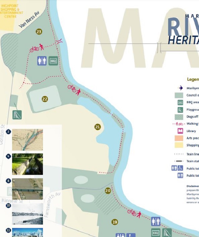
19. Footscray Park
The beautiful Footscray Park is a testament to the people of Footscray and to long-standing curator, David Matthews. Originally owned by the Victoria Racing Club [VRC], it was a popular spot from which to watch the Melbourne Cup for those who couldn't or wouldn't pay to enter Flemington Racecourse on the opposite side of the river. When the VRC planned to sell its land on the Footscray side of the river in 1908, citizens of Footscray urged the Council to buy it. The state government assisted the Council to do so. Noted architect Rodney Alsop designed the gardens and a citizen's committee worked with David Matthews to carry out the design, donating labour and plants. During the 1930s Depression sustenance workers employed by the Footscray Council drained low-lying land to create the adjacent sports fields. The park is a significant example of Edwardian garden design, including formal and informal pathways, garden beds and pergola. Some hidden treasures include the Henry Lawson memorial, a platypus fountain and a shelter built by Footscray Technical School.
20. Footscray Rowing Club
Rowing was a popular sport on the Saltwater and Yarra Rivers in the nineteenth century. Footscray Rowing Club was formed in 1873 and achieved glory in the early 1880s when it won the prestigious Clarke Challenge Cup. The Hon. W.J. Clarke, M.L.C. donated a silver cup to be won by crews of eight from any rowing club in Victoria who could win the challenge in three consecutive years. The two mile course began near the mouth of the Yarra at Newport, finishing just below Shepherd Bridge. Corio Rowing Club won the first race in 1879, but Footscray won the next three years' races and became the first club to win the cup. A crowd of 20,000 thrilled at the sight of eight working men from Footscray, in a donated boat, beat the more established Melbourne crew in 1882. The next year the Victorian Rowing Association banned manual labourers from competing in amateur rowing competitions, making it impossible for Footscray's finest oarsmen to compete in any further regattas. The Footscray Rowing Club was succeeded by the City of Footscray Rowing Club in 1894. The present rowing club building replaced a timber building dating from 1925.
21. Edgewater - Former Ammunition Factory
The Edgewater Housing Estate occupies the site of the former Commonwealth Munitions Factory, some remnant buildings of which are still located on the upper portion of the site near Gordon Street. The Colonial Ammunition Company (CAC) built an ammunition factory on the river flats at Maidstone in 1889, aiming to reduce the colony's dependence on imported munitions. In the early twentieth century CAC expanded their works to begin producing cartridge cases and bullets.
The Commonwealth Government purchased the ammunition factory in 1928. During WWII the Ammunition factory was Australia's largest and most important ammunition factory, employing over 9,000 workers, including many women. Because of the volatile nature of the operations the 'factory' was a series of separate buildings and the site stretched from the Lang's Road Bridge to the southern boundary of the present Pipemakers Park, incorporating the Powder Magazine (site 22) The factory's operations were gradually scaled down after World War II, when low-lying land on the southern portion of the site was leased to Myer Limited for storage. Australian Defence Industries took over the Ammunition Factory in 1989, closing it in 1994.
22. Jack's Magazine
The bluestone perimeter wall of Jack's Magazine is clearly visible from the walking path. Within the walls a complex of vaulted storage buildings remain. Initially known as the Saltwater River Powder Magazine, it replaced the Footscray Powder Magazine (site 5) as the main storage depot for explosives in Melbourne in 1879. Noted architect William Wardell designed the complex which originally contained two bluestone magazines surrounded by the 10 metre high earth mounds which can still be seen today. Vessels carrying imported explosives unloaded at riverside wharves onto smaller craft, which carried the explosives via a canal to a loading dock at the entrance to the complex. The Truganina Explosives Reserve at Altona replaced the Saltwater River Magazine as Melbourne's major storage depot for explosives in 1901. However, it remained in use for the storage of ammunition, with additional brick stores constructed during the busy World War II period. Unofficially, it became known as Jack's Magazine after its keeper from the 1920s, Wally Jack. The course of the canal, now filled in, is clearly discernible, running between the bicycle path and the bluestone surrounding walls. Some remnants of the wharf can also still be seen from the bicycle path.
23. Pipemaker's Park
Pipemakers Park, now managed by Parks Victoria and home to Melbourne's Living Museum of the West, has an industrial history lasting from 1847 to 1979. It began as one of the earliest meat by product sites along the Saltwater River. In 1847 Joseph Raleigh began boiling down sheep to make tallow for candles and soap-making. In the 1850s an engineering firm, Robertson, Martin and Smith, responsible for building the first steam locomotive in Victoria, occupied the site.
The bluestone buildings and chimney that remain today date from the 1868 to 1888 period when the Melbourne Meat Preserving Company, preserved and canned meat here. Several hundred people were employed here in the 1870s, when the company was Australia's leading exporter of tinned meats. Like William Angliss in the next century, the meat preserving company built workers' cottages nearby. The river adjacent to the company's wharves was dredged to provide a turning circle for vessels transporting canned meat and soups directly to ocean-going ships moored in Hobson's Bay.
For a time in the early 1880s the Australian Frozen Meat Export Co., reputedly the first successful exporter of frozen meat in the world, shred the site before moving to new premises in Newport. The preserving works closed in 1888, when there was a decline in demand for its products. Humes Pipes, the largest manufacturer of steel reinforced pipes in Australia, was based here from 1911 to 1979.
Like so many of the sites featured along this trail, Pipemakers Park provides a glimpse of an industrial heritage along the river dating back to early colonial times. While the riverside industries defined Footscray as an industrial centre and provided employment for many locals, their importance spread far beyond Melbourne's west. The products of these industries were shipped across Australia and overseas, helping to support rural industry, feed the nation and supply Australian troops in several wars. For many decades the busy Maribyrnong River wharves were an essential component of the Port of Melbourne. The tranquil, mirrored surface of the Maribyrnong River today reflects only traces of its long industrial heritage.
Location
Cnr Cowper Street and Youell Street, Footscray 3011 Map
Web Links
→ Maribyrnong River Heritage Trail Brochure and Map (PDF)
→ Maribyrnong River Heritage Trail Booklet (PDF)
")


")