Maldon - Lisle's Reef Walk


A walk on Mt Tarrengower offers a lot of history, a gentle descent, many points of interest, and a shorter but steeper return trail. The return can be made less strenuous by backtracking on the outgoing path.
The numbers refer to concrete ground markers at most of the points of interest and to the map below.
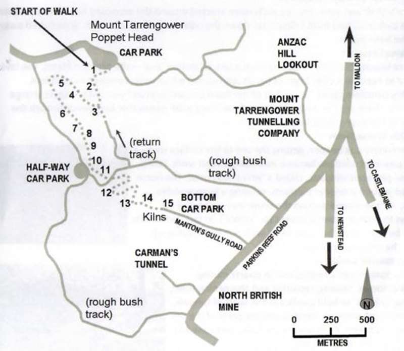
START the walk from the carpark at the lookout on top of Mt Tarrengower - walk diagonally across the open area to the right of the cream brick building at the base of one of the communications tower, to the signpost ("Lisle's Reef") at the start of the track. Caution: The track is narrow and uneven in places. Keep to the tracks for your safety and to avoid damage to old mine workings.
1. COPPICING When a eucalypt is cut down, buds under the bark sprout and a cluster of smaller trees then grow. The original stump rots away. Apart from native grasses, such as Wattle Mat-Rush, these hills would have been bare, the trees being cut down to use for the mines.
2. THE START OF REEF WORKINGS Before a shaft was sunk, low log walls were erected around the proposed hole. This prevented waste rock (mullock) from falling back down the hole. These log walls have since rotted away or have been burnt.
3. PLAINS LOOKOUT You are looking out over what was once a lake of molten lava - the Moolort Plains. The lava cooled to become a deep layer of basalt (bluestone) which covers ancient river valleys, possibly containing gold. To the left of the Cairn Curran Reservoir you can see several large mounds. These are the mullock heaps of the 'deep lead' mines that burrowed through the basalt to the river valleys below.
4. 1870s WHIM SHAFT As the miners dug deeper, getting the ore to the surface using a hand powered windlass became increasingly hard work. Hence, a horse powered windlass, called a 'whim' was used. The horse walked around a circular platform, rotating a large wooden drum. A rope wound around the drum was connected via pulleys to raise or lower a bucket (or `kibble'). In fact, two shafts could be worked at the same time, with one kibble going up while the other went down.
5. BLACKSMITH'S SHOP The blacksmith had a central role in quartz mining. Shoeing horses; making, repairing and sharpening tools; making 'spiders' to hold candles in the walls of tunnels; and, repairing windlass handles and the parts of the ore crushing batteries, were among the tasks performed by blacksmiths on the goldfields.

6. 1870s BIGGER MINES At the head of the gully, the landscape changes. With richer soil comes larger trees and more weeds. On the slopes above are small workings done the hard way with hand powered windlasses. From here you will encounter the main workings with deeper mines and more evidence of the extensive surface workings. One hundred metres down from here, as you cross the gully, to the right is one of the best preserved 19th century blacksmith's shops in Victoria.
7. CARTING TRACK After meandering back and forth across the upper gully, the track commits to the right-hand side and widens. You are now walking on an 1870s cart track.
8. BATTERY SITE Just below you on the left is an unusual looking pile of stones. It is the remains of a chimney stack constructed in 1859. It was part of a small battery. Because of a lack of water, it was relocated further down the gully. This relic is probably the earliest surviving mining artefact in this gully, and perhaps in the Maldon district.
9. VIEWING PLATFORM ABOVE ZIG-ZAG TRACK On the opposite side of the gully are mine workings associated with Braithwaite's Reef. Many shafts were sunk on this reef, the deepest being by the Mountaineer Company in 1869. Look down - immediately below you can see zig-zag carting tracks, designed to lessen the slope for work horses.
10. MULLOCK HEAPS VIEWING PLATFORM Back off the track, up the gully, you will see a viewing platform. All the rocks spilling down the hill were hand dug and hauled up from the shafts by whims.

11. WHIM PLATFORM This is the best preserved whim platform on the walk. You can see the centre post hole of the whim drum, the narrow platform worn around the perimeter of the platform by the plodding horse, the mine shaft and the associated mullock heaps. From here, turn left onto Cox's Track, then left again at the Cox's Track/Manton's Gully Track marker pole. After a bit of a slog up the other side of the gully, you will meet the outgoing trail at viewing point 3. An alternative route would be to turn right into Manton's Gully Track and experience the following sights.
12a. WHIM PLATFORM See the stone retaining walls made from mullock to level the platform.
12b. QUARTZ PADDOCK Where the quartz raised from the mine shafts was loaded and carted down to be processed.
13. END OF MAN (AND HORSE) POWERED WORKINGS Times changed and mechanisation altered everything for the small player, who was no longer an adventurer and had to become an employee. At this moment of reflection, spare a thought for the Swift Parrot, now rare and endangered, whose winter feed of the blossoms of Box and Ironbark eucalypts disappeared into the boilers that powered every aspect of the gold mining boom.
14. THE NEW WAY: CUTTING TO A MINE ADIT (A HORIZONTAL MINE ENTRANCE) In 1879, the Grand Junction Company got rid of its tributers (subcontractors) and started their own operations on a very large scale, using new machines and hired labour. For all of their new technology and labour practices, it took three years to reach a gold bearing reef. They found plentiful gold and in 1883 erected a large battery and kilns...
15. GRAND JUNCTION KILNS AND BATTERY ... and to your right you will see the kilns.
An optional extension to the walk may require one of you to finish the circuit back up to the top of Mt. Tarrengower and driving down to Parkins Reef Road, or the use of two cars, one at the top and one at the bottom! From the kilns at point. 15, walk down to the end of Manton's Gully track onto Parkins Reef Road.
This walk was produced using material from 'Discovering the Mount Alexander Diggings'.
Review:
This is an interesting walk but we did have quite a lot of trouble following the path on the map because the track was very indistinct. Generally follow the gully / dry creek bed and keep that rough bush track on your right between points 5 and 11.
At the start near the Mt Tarrengower lookout tower there are two seats and a table. These are the only facilities on the walk.
Photos:
Location
Mount Tarrengower Road, Maldon 3463 View Map


")