Longwood East - Big Hill Nature Conservation Reserve Walk

More than 56% of Granitic Hills Woodlands in the Goulburn Broken Catchment have disappeared since European invasion. Historically, parts of Big Hill were cleared of trees and grazed, but areas of intact woodland and escarpment shrubland remain.
Topography and Geology
The Reserve is a high value granitic hill woodland that exists for nature conservation. Even at what sounds like a relatively low 372m elevation, the views across plains, rolling hills and mountains are stunning.
Flora
Many of the plants and animals that rely on this habitat are now threatened, and some are extinct. This is one of the last remaining public land examples of quality habitat on the rocky, western slopes of the ranges. Big Hill also links to important large patches of private remnant bushland along Winding Creek, up to Gap Rd and Panorama Drive above Longwood East.
There are examples of indigenous vegetation with considerable floristic or habitat value in a relatively natural state. It is a perfect location for recreational pursuits such as nature study, walking and photography associated with appreciation of the area.
Granite country, with outcropping rocks and sandy to sandy-clay soils, typically has low water holding capacity. The low woodland overstorey is usually dominated by Blakely's Red Gum, with Red Stringybark, Red Box and Long-leaf Box. The shrub layer consists of Hickory Wattle and Drooping Sheaok, Common Fringe-myrtle, Lightwood, Box-leaf Wattle and Varnish Wattle. Clumps of correa reflexa and native fuchsia grow amongst the rocky shrub and herbland. Ground layer species include Nodding Blue Lily, Austral Carrot, Raspwort, Cotton Fire-weed, Green Rock Fern and Austral Stonecrop.
Location
The 62h Big Hill Nature Conservation Reserve is easily accessed from Faithfull Rd (Old Hume Hwy), 1 km beyond the Longwood-Ruffy Rd turnoff. There is ample parking in the Old Hume Hwy truck siding. Initially, it is a fairly easy north-south walk up to the summit - approximately 140m in altitude. Walk across the downed fence, follow the track to the left and then up the spine of the hill to the first outcropping (Wool Pack Rocks). Another 100m takes you to the summit.
Map of Walk Route
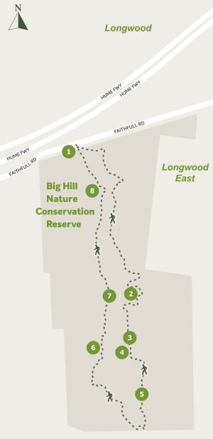
1. Car parking
2. Wool Pack Rocks
3. View north east to High Country
4. Trig point
5. View east to Mt Wombat
6. Escarpments and boulder falls
7. View north to Murray Country
8. Tessellated pavement
There are two walk options. Short walk track 1.6km return Big Hill summit or Long walk 3.5km loop (no track).
If you want to walk over the back and around the sides of the hill some areas are quite challenging, be prepared for lots of rock hopping and very steep gradients.
Access for Dogs:
Dogs are not permitted.
Location
Faithfull Road, Longwood East 3666 Map
Web Links
→ Walk Notes - Big Hill Walk (PDF)
")


")