Kilmore Creek Heritage Art Walk


This gentle 2km trail along Kilmore Creek is suitable for walking, running, cycling and dogs on a lead.
This gentle walk along Kilmore Creek celebrates Kilmore's rich and diverse history from indigenous occupation through colonial settlement to a vision of the town's future. Along the walk, enjoy a series of artist-designed panels and sculptures which will help you understand the town's long history. Learn about the significant history of Kilmore as the oldest, gazetted and settled inland township in Victoria.
There are plenty of benches along the path to stop and rest or enjoy the views.
The walk is divided into 3 stages, with the final stage featuring a garden designed by the youth of Kilmore.
Stage 1. Union Street to Skehan Place
Panels 2 to 4 show the 'history of the Taungurung, whose nine clans lived around Kilmore for thousands of years. These panels also describe their food resources, weapons and tools.
Stage 2. Foote Street to Rutledge Street
Panels 5 to 8 tell the story of colonial settlement when Kilmore was declared the earliest settled and gazetted inland township in Victoria. Just west of Ryan's Road, among the gum trees, there is a metal sculpture of a horse indicating the importance of horses in Kilmore's early colonial history.
Stage 3. Sam Gabrielle Reserve
At the southern end of the walking track there is a garden designed by the young people of Kilmore who have also written their thoughts about the future of the town. These ideas will be buried in a 'time capsule' with other memorabilia to be recovered at a future date.
Map of Route
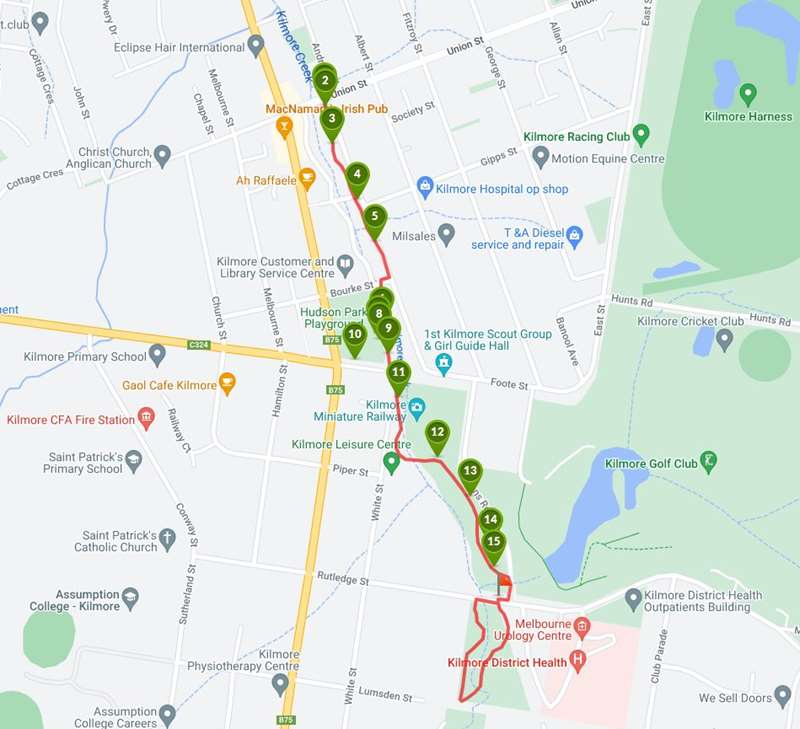
Points of Interest on route:
1. Paved path
The first section of this track is along a concrete path
2. Introduction Panel
View a map of the walk and discover the stages available along the way.
3. Panel 2
Taungurung History
The people of Nira Bulok clan (cave dwelling people) occupied the Kilmore region for over 30,000 years prior to colonisation. This clan was one of the nine clan groups that comprised the Taungurung people whose vast area covered much of central Victoria, from the Campaspe River in the west, High Country in the east, below Benalla in the north and to the top of the Great Dividing Range in the south.
Clans consisted of around 400 individuals who belonged to either Bundjil (wedge-tail eagle) or Waang (crow) moiety, a system that strictly controlled marriage eligibility, ceremonial rites and clan cohesion. Taungurung and adjoining tribes formed an alliance called the Kulin nation where the tribes shared a similarity of language, custom, ceremony and moiety.
4. Panel 3
Taungurung Food and Resources
The Kilmore region provided an abundance of food for the Nira Bulok clan. Women foraged for small animals: dhulin (goanna) and gawarn (echidna) and collected fruits, seeds and roots while on the surrounding grasslands, men hunted larger game such as marram (kangaroo), warriin (wombat) and barramul (emu) and fished the local waterways. Clan movements were dictated by the seasonal abundance of food such as annual visits to the high country during summer to feast on the protein rich debera (bogong moth). A much sought after stable plant, rich in starch, was the mirnong (yam daisy). This favourite plant was roasted in camp fires, however it has now become scarce due to grazing of sheep. Other important starchy foods included milkmaid, bulbine lily and potato orchid. The Taungurung fully utilised all suitable plants and their products for medicine, food, drinks and as tools to procure their food.
Mirnong (Yam Daisy) - Clans practised land management to cultivate the mirnong, which requires a lot of sunlight to thrive. They would burn around the mirnong crop on a rotational basis to keep taller plants from dominating, while also fertilising the ground. The burning was timed for when the leaves browned thus protecting the roots from harm.
The seasonal abundance of fish, yabbies, turtles, mussels and frogs in the local rivers ensured a varied diet. Fish were gutted and cooked in a manner to retain their juices with turtles being cooked in their shells. Smaller crustaceans were cooked over coals in the hollowed elbow or knot of trees. Evidence of the remains of these banquets deposited over many generations can still be found in the large middens, often metres deep, located on the banks of waterways.
5. Panel 4
Taungurung Tools and Equipment (this panel is currently missing)
6. Kilmore Skatepark
The skate park is located in Hudson Park.
7. Outdoor Fitness Equipment
The outdoor gym is located near the playground.
8. Hudson Park Playground
This open space with playground is a great place to exercise, meet friends for a BBQ, and take the kids for a play.
9. Panel 5
Early Explorers
The area around Kilmore township came to the notice of authorities when in 1824 Hamilton Hume and William Hilton Novell made their epic journey from Hume's property at Appin NSW, arriving at Corio Bay believing it to be Westernport Bay. The party passed east of Kilmore township on the 13th December 1824, and ascended the hills to survey the landscape before them. Today this gives us an appreciation and understanding of the route and landscape of the exploration party.
They travelled with six convict servants and arrived on 16th December 1824 without loss of life or serious injury. The expedition was deemed a great success and the explorers recorded important features such as rivers, the Great Dividing Range and vast, potential grazing lands in Victoria of which Kilmore would have been part.
The Henty Brothers settled Portland in 1834 and John Batman formed the Port Phillip Association to further investigate the region. This led to the colonisation of Victoria and the settlement of Port Phillip district, now known as Melbourne in 1835. Lady Jane Franklin (1781-1895) was the wife of the Governor of Tasmania, Sir John Franklin. They arrived in Hobart from England in January 1837 and returned to England in 1843. While in the colonies Lady Jane Franklin was probably the first European woman to travel overland from the newly settled town of Melbourne to Sydney in 1839. She kept a diary of the trip and recorded that on the 8th April 1839 her party arrived at Mercer's Vale, later called Beveridge, and then travelled north to what is now Kilmore. Her party had travelled over the eastern part of Hidden Valley Boulevard, according to her description of the terrain. She also writes that they passed through Green's Outstation now known as Green's Pinch, a few hundred metres north of the Kilmore-Broadford turnoff (Northern Highway - Broadford intersection). As a result, pioneer settlers were encouraged to travel overland and settle the areas opened up by this early exploration.
10. Public Toilet
Located in Hudson Park
11. Panel 6
Survey and Establishment
The Kilmore Creek area was first settled in 1837 by squatters who overlanded stock from Sydney to the newly established towns of Port Phillip (now Melbourne), Belfast (now Port Fairy) and Portand, on the coast.
An area of 5120 acres west and around the Kilmore Creek was taken up as the Willowmavin Special Survey by William Rutledge and gazetted as the town of Kilmore in 1841 making it the first inland town of Victoria. The surveyed town blocks were slowly established as businesses trading with overlanders and travellers between Sydney and Port Phillip.
A postal service was operating to the Kilmore district by horse at this time but the first post office was opened 1st February 1843. Stables were soon set up for coach horses, and hotels and shanties were built to accommodate travellers and new residents.
Several schools had been operating in the district from 1841 until 1868 when the Education Department was advised that the system be changed owing to "too many schools existing at that time". In 1874 the Kilmore State School was established at it's present site. The Catholic Sisters of Mercy opened their school, St Joseph's Ladies' College, on the present site of Assumption College in 1875, The Marist Brothers opened Assumption College for boys in 1893 at the present site of the Kilmore International School. In 1914 owing to lack of space for the boys, the Sisters and Marist Brothers exchanged schools. The Kilmore International School was established in 1990 in White Street. The Courthouse was built in 1863 and Police Barracks in 1893 to the west of Kilmore Creek.
12. Panel 7
Agriculture, Business and Sport
The Willowmavin Survey was slowly tenanted by farmers from Ireland and Scotland. Potatoes "as big as footballs" and grain were early crops grown to feed the expanding population of Port Phillip.
Quality bluestone quarries and gravel pits were opened up along the Kilmore Creek. Local bluestone was quarried to build mills for the grain industry. Abattoirs were constructed for the cattle and sheep industry and a dairy was commenced in the old Kilmore Gaol in 1890 to make it's famous butter.
The first Catholic school was started in 1844 and the Parish established in 1849. Anglicans and Presbyterians built large churches a few years later.
Gold was found in the district but Kilmore's banks and stores continued to service travellers to and from the Bendigo and Ovens districts' goldfields.
Sporting activities were popular including horse racing (the first race meeting said to have been conducted about 1853) and cricket in the 1850's. There was also a Total Abstinence Society and Mechanics Institute and Free Library, a Hunt Club, an Agricultural Society and a Rifle Club. Kilmore was the site of a very large military training camp in the early 1900's.
13. Panel 8
Further Immigration
While most of the early settlers to Kilmore came predominantly from the British Isles and were mainly of Celtic origins, Kilmore has seen many groups of non-British migrants arrive over the years to settle in an already established thriving community.
From the 1850s on, Chinese migrated to Australia. Most of them were attracted by the discovery of gold. A famous market garden at the north end of town, near the stone bridge, gave the area the name "Chinaman's Bridge". After the Second World War, there was an enormous wave of European migration, which lasted from the late 1940s until the 1950s. Many of these immigrants were initially drawn by the Snowy Mountains Scheme, but remained in Australia after it's completion with a number of these people settling in Kilmore.
The Kilmore International School was founded in 1990 and continues to function drawing in many students from Indonesia, China, Japan, Philippines, India and Thailand. The business area of Kilmore has further attracted people of different nationalities, who have contributed many positive elements to Kilmore, including a variety of cuisines and customs. Kilmore has become a truly successful multicultural community.
14. Horse Sculpture
by Sean Diamond
15. Student Garden
Mosaic Art. This garden was conceived by the students of the town, both local and from away. A mosaic-style composition depicts the sun's rays shining down on the township.
Photos:
Location
Cnr Union Street and Victoria Parade, Kilmore 3764 Map
Web Links
→ Kilmore Creek Heritage Art Walk (Walking Maps)
")


")