Jamieson Short Walks

Here are a few short walks. All are close to the town and the longest will take about 90 minutes to complete. Keep your eyes open for the beautiful native birds and wild flowers. If you're lucky, you may even spot a Platypus while down by the river.
Map of Short Walks
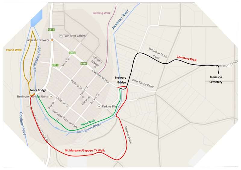
A. MT MARGARET TRACK/SAPPERS TRACK
This is a pleasant walk which will take you from Foots Bridge up over the hill, then down to Brewery Bridge at the Eastern end of town. The track overlooks the township and offers view of the town which are particularly beautiful in Autumn.
There is an information board at Brewery Bridge.
B. THE RIVER WALK
Near Brewery Bridge on the west bank of the Jamieson (the town side) is a pleasant picnic spot known as The Little Pool. There's a shallow swimming hole for the younger children and it's a great spot to sunbathe, picnic or just relax in the shade of the big trees.
Further along the riverbank is The Brewery Hole, another good picnic spot. The Brewery Hole is considerably deeper (1.5+m) and is so-called because it was the water supply for the old Goulburn Brewery (1864-1901) which was situated on the opposite bank of the river.
Keep following the river and at Cobham Street, Juddy's Hut will be right in front of you. This is a good example of an early miner's cottage and was named for Jack "Juddy" Hampton who was a well-known local identity. An information board will give you more details of Juddy's exploits in WWI.
Continue to follow the river and you will discover further pleasant picnic spots right on the river. Soon you will reach the Caravan Park. You are welcome to walk through the Caravan Park, but if you have a dog, please keep it on a leash.
After you emerge from the Caravan Park, you come to The Big Pool, a popular swimming hole and picnic area. There is a coin-operated BBQ and a kids playground.
You are now almost back to where you started at Foots Bridge. If you wish to walk a little further, cross the bridge and turn right into The Island.
C. THE ISLAND
This piece of land is not really an island having water on only 2 of its 3 sides. At the foot of the island, the Jamieson and Goulburn rivers come together before flowing into Lake Eildon. This can be quite a spectacle in winter if the rivers are running high.
The Island once belonged to Dr Andrew Nash, Jamieson's first doctor and some apple trees from his orchards are still growing here. Once overgrown by blackberries, The Island was cleared and many native
trees have been planted there by Jamieson community. It's a great spot for a picnic or for fishing.
D. CEMETERY WALK
This time, start from Brewery Bridge and immediately pass Dr Pomeroy's Cottage on your left. This was built by some of Jamieson's earliest settlers and just beyond are the lush flats where tobacco was grown. The last of the kilns were demolished in the 1980s.
Turn right at the end of the Recreation Reserve (where the road turns to dirt) and follow the Licola Road for about 1 km. The Cemetery is on your right overlooking the lovely Jamieson Valley.
At the cemetery, you will find headstones marking the final resting place of many of the early settlers and pioneers. Among the graves are Herman Berger and his son Alexander, the Ridge family, the Allens of Ten Mile, Alfred Hobday, Richard Dale, the McCormacks, McQuiltons, Foots, Hoskins, Wheelers, Mountfords, Petersens, Gerrans, etc. Many of these names are still prominent in the district today.
A separate leaflet and plan of the cemetery can be obtained from the Museum on Nash Street.
E. SCHOOL HILL
This is not a walk for the faint-hearted. At times, it is quite steep as it climbs to the top of the hill where the mobile phone mast is situated.
There are two points of access to the track. One from Chenery Street via the Mary Street track, the other
from The Sideling where the track heads up behind the school residence. The latter is less steep.
At the top, the views are spectacular. You can continue following the track taking the left hand fork to bring you back onto the Woods Point Road near the old Bells Mill.
F. THE SIDELING (old Laidlaws Road)
A stroll along this road will take you up the Jamieson Valley. After the first kilometre, it becomes a private road but residents welcome you to continue walking provided you stay on the track and behave appropriately. The track finishes at the gate of the last house on the private road. You must return to town by the same track.
Location
52 Chenery Street, Jamieson 3723 Map
Web Links
→ Jamieson Short Walks Brochure (PDF)
")


")