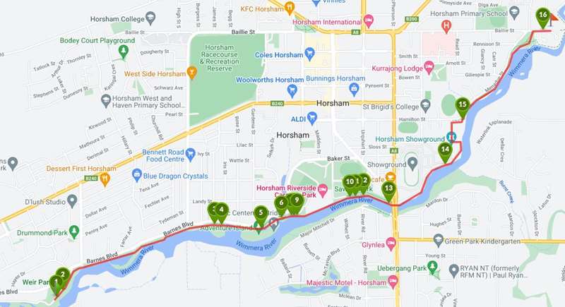
Horsham Weir to Baillie Street River Walk

This scenic one way walk follows the Wimmera River all the way from Weir park to Baillie Street. It is a safe track with no main road crossings and has plenty of interesting things to see along the way.
Starting at Weir Park at the end of Drummond Street, this track is continuous all the way to Baillie Street. Along the way there may be small bridges to cross, playgrounds, various grassed areas to stop and rest, and plenty of places to stop and park your car if you only want to walk part of the track.
Map of Route
Interactive Map
Points of Interest
1. Double Canoe Tree
The Goolum Goolum Aboriginal Co-operative Ltd placed this here in 1997 after the family on whose property the tree stood at in Lubeck until 1977 donated it.
2. Weir Park
Formerly called Jaycees Park. This was developed during the beautification in the late 60's as well as building of the new weir in 1968.
3. Fitness Equipment
A chance to break up your walk with some exercises along the way. Choose from 4 pieces of equipment
4. Horsham Fly Fishers and Trout Anglers Club
Due to the drought trout fishing has not really been possible. With the lakes now having water and fish added, trout fishing has once again become popular
5. Apex Island and Playground
This is a man-made island built by the local Apex clubs during the river beautification of the 1960's and 70's.
6. Rowing Club
This was built in 1976. The club was formed in 1883 although their first regatta was not held until 1972
7. Apex Club
This is the home of one of the local Apex clubs. Up until the 1980's you could hire paddleboats from here.
8. Old Horsham Weir and Swimming Pool Historical Sign
Site of Horsham Weir 1875-1959. Used as swimming pool until the new weir was built
9. Flood Markers
These indicate three of Horsham's largest floods, in 1909, 1981 and more recently 2011. The second is an indication of the water height of the 1909 flood if the river beautification was effective.
10. Soundshell
The soundshell was built in 1986 and is the site of many events including the Kannamaroo Festival and Carols by Candlelight.
11. Sawyer Park
This land was owned by the Sawyer family who ran brickworks on this site from 1874-1939. At the eastern end of the park is a replica kiln built from bricks made at the brickworks.
12. Memorial Cenotaph and Vietnam Memorials
The Memorial Cenotaph was designed and most of the erection completed by the RSL and volunteers in the town. Opened in 2004
13. History of Bridges and Tramline Historical Sign
A horse drawn Tramway opened in 1885 transported road-making materials from McKenzie Creek (six miles south of Horsham) on second hand railway trucks
14. Seeliger's Brewery
Ernst Seeliger worked as a brewer in South Australia before purchasing the Wimmera Brewery from Treacy and Smith at Meadowbank near the showground.
15. Swinging Bridge to Old Golf Course Sign
This is the site of the 4th tee of Horsham's second Golf Course. Players hit across Burnt Creek. A pedestrian swing bridge crossed the river to reach the course.
16. Old Pumping Station
Walk south towards the river to find the sign. The pumphouse for Horsham's first reticulated water supply was built near this spot about 1875.
Location
135 Barnes Boulevard, Horsham 3400 Map
Web Links
→ Horsham Weir to Baillie Street River Walk (Walking Maps)
")


")