Fryerstown Heritage Walk

Fryerstown was originally called Fryer's Creek. The name was changed to Fryerstown in 1854 when a survey was carried out and it became a township. In its heyday, following the discovery of gold, Fryerstown had a population of 20,000, numerous shops, 25 hotels, 5 breweries, 5 churches, 2 schools, a courthouse and brickworks.
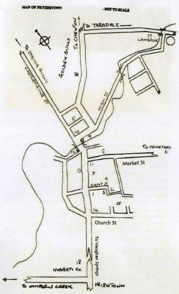
Fryerstown Heritage Walk Map
The Mechanics Institute [1], also known as the Burke and Wills Hall, was opened in 1863. Its opening was a grand affair with the local brass band playing and All Saints Anglican choir singing, the ceremony being concluded by a sumptuous banquet. A library was added in 1864 and the hall was extended in 1892. The Hall and its surroundings is the site for the annual Fryerstown Antique Fair, which has been a regular event in January since 1974. Attached to the hall is the Library. It was operated as a lending library from 1864 - subscription 10/- per annum. The reading room was open from 7.30 pm to midnight. Many of the books are still there. In later years it accommodated the euchre players when dances were held in the main hall.
Heading towards the school [2] on the right was the site of the original court house, built in 1858 for 230 pounds, the police barracks and log lock-up. The site was however, subject to periodic flooding and was moved to higher ground on the opposite side of Camp St. Just over the culvert on the right is the tree reputed to be where male prisoners were chained before the lock-up was built [3].
Up Camp St is the schoolmaster's house, which originally was the Police Barracks [4]. It passed into private hands from the Lands Dept in the 1990's. The School House and Police Stables (1884) were still intact in the 1980's, with cedar weatherboards and a stone floor in the stables that sloped to a central drain channel. The stables have recently been restored using the original plans.
The original school building opened in February 1853 replacing the earlier school tent. It was next to the Methodist Church on the hill [5]. It consisted of a large stone room, 2 weatherboard rooms and a lobby. By 1907 the town population had dropped to 3,000 and there were between 200-300 pupils. In 1915 the average number of pupils was 90 and a new school was opened on this site.
It Is possible to see the site of the present fire station from the school grounds. There was a burial ground in front of the fire shed. The bodies were exhumed in 1910 and reburied in the Fryerstown Cemetery, which can be reached up Market St.
Retrace steps from the school and turn right through Camp Reserve. This whole area was public land - part of which was originally reserved for a market, but it seems it was never used for that purpose. On the left is a heritage listed tree [7] with a large scar attributed to local aborigines cutting bark for a canoe. The large tree near the court house was used for chaining female prisoners awaiting the hearing of their case.
Behind the tennis courts is an area originally designated for public entertainment and recreation in the original town plan. Many sports were popular including cricket, wrestling, pigeon shooting, prize fighting, horse racing, skittles and tennis. Entertainment including white minstrel shows - The Fryerstown White Rose Minstrels entertained children and adults and the town had its own brass band. Concerts including tunes by "bones" players as well as choral items and piano recitals were popular and so were "silver readings" which were public readings of works by famous authors, and dances. Into Marker St, right past the court to the former Shire Pound - a small fenced area at the eastern end of the tennis courts. The Shire had an office on this land and it was still there until after the 2nd World War when the iron roofing was removed and It deteriorated.
Returning along Market St. On the right before the house was the National Bank [8], opened 20th August 1859. It later became the Bank of Victoria.
Cross the bridge noting the stonework below on the right. On this side was North Parade following the creek, with the Corner Hotel [9] (originally the White Hart, partly destroyed by fire In 1883 on the corner. It closed in 1922.
Opposite, on the corner of High and Castlemaine Streets, was Carter's Boot Factory [10]. The present owners restored this some 20 years ago. Prior to their acquisition of the property, the contents were auctioned and the machinery went to the Swan Hill Pioneer Settlement. This building was erected in 1870 by George Levi Carter to replace an earlier small cottage. George Carter's first wife died leaving him with 2 young children. He subsequently married a Miss Radcliff with whom he had 7 more children and died in 1923 aged 96. He was a man to whom considerable respect was accorded by his contemporaries. He was a JP, foundation member of the Cemetery Trust, member of the original Burke and Wills Mechanics Institute, a lay preacher in the Wesleyan Methodist Church, a shire councillor and Shire President for three terms, He was also Postmaster for over 40 years, operated the boot manufacturing business and was a keen astronomer delivering many lectures on the subject.
On down Castlemaine St, past the Boot Factory, to view the former Methodist Church [5] on the hill to the right and the Sunday School next to the church. The Sunday school was brought out by ship in the 1850's. Retracing our steps past two old cottages, which were transported here and somewhere along this side of the street was Stoneman's Bakery, run by the brother of Richard Stoneman the grocer. On the right just before recrossing the bridge is a new brick house. Originally this site was occupied by Delaray's Lolly Shop, which also served as a Post Office for a while. The old building was still here in 1982.
Back over the bridge - the house on the right was a butcher's shop.
The corner of Market St, originally the site reserved for a tennis court, is now occupied by the former Court House [11], opened in September 1880. The last case was heard in 1916 and since 1930 it has been a private residence. The Diggers Rest situated next to the Court House in Castlemaine St was later renamed the Freemason's Hotel and was used as a magistrate's court before the first court house was built.
Heading up the hill, on the right the empty paddock was the site of the Bridge Inn [12], de-licensed in 1913 and eventually demolished. Next to it was the Cumberland Hotel where the Cornish miners used to meet. Tenders for the building of Moore Bros store [13] were called in January 1859. Part of the store, the house with the creeper was the last Post Office building in Fryerstown and was operated by Mrs Olive McDonald, closing in 1975 on her retirement.
Further up the hill on the left before All Saints Anglican Church [14] is a much-extended old home that belonged to the Kitto family. Richard Kitto was a Mining Surveyor and Registrar from 1860 to 1868 when he resigned and was appointed Managing Director of the new Duke of Cornwall Company. In 1868 he was elected as the Castlemaine district's representative in the Legislative Assembly of Victoria. He was responsible for the building of the first public powder magazine for the storage of explosives used in the blasting of quartz and in having an urban water supply connected to the town. This was linked to the Crocodile reservoir - a supply that lasted for over 100 years. The new pipeline was laid about 1989, the water then coming from the same source as that of Castlemaine. Richard Kitto left to take up a position as manager of a mine in Scotland in 1874.
All Saints Anglican Church [14], now a private home, opened in 1861 and could seat 120 people. Opposite it is the site of the Presbyterian Church, which was taken down and sold after 1943. The materials were used to construct the sheds at the Anglican vicarage. Next to it was the fire shed, bell tower and overhead stand-pipe for filling the tanker - the latter is still there.
If we continue up Church St past Modesty Cottage turn left along Gladwin St where it is possible to see the original private school [15] established by Cornelius Gladwin. He held classes in the evenings. The property has one of the few monkey-puzzle trees in the area.
From here you can return to the Mechanics Institute Hall by retracing your steps down the hill.
There are several things to see on the outskirts of town: Heading out of Fryerstown towards Chewton is the Duke of Cornwall Quartz Mining Company engine house [16], built strictly to Cornish design in 1868 and housing a 75 horsepower engine with a 22 feet diameter flywheel weighing between 20 and 30 tons.
Unfortunately the mine was not successful and the company became defunct. The house opposite was the home of the original mine manager. The Duke of Cornwell plant was sold by auction in 1875 and the Rowe Bros purchased it for 1850 pounds, considered a very cheap price for the plant. The Duke of Cornwall was never very successful and was used to process ore from the Rowe Bros Mosquito mine, which was opposite.
Lambruk [17], the home of Edward Rowe was built in 1868 of local sandstone with a garden laid out by a Melbourne landscape gardener at a fee of one thousand pounds. This is on the Taradale Road from Fryerstown and can be viewed from the cricket ground opposite in High St. Edward Rowe was one of five Rowe brothers who arrived in Fryerstown from Cornwall, England in 1858. They were extremely successful in the early quartz reef mining and Edward's house stands as a testament to the success of this phase of mining in Fryerstown.
Leaving town on the Campbells Creek road you will see Nuggety Gully [18], Irishtovvn, Churches Flat and Breakneck Hill which had their own stores, breweries and hotels but only remnants remain. This area was subjected to sluice mining when the deep mines were no longer operating.
Compiled from a walking tour presented by D. Linton in 2000 with some research by the Castlemaine Historical Society, and G.O. Brown's book "Reminiscences of Fryerstown". September 2007.
Location
Cnr Castlemaine Street and Camp Street, Fryerstown 3451 Map
")


")