Fish Creek - Hoddle Mountain Trail

This walk passes through an area of national geological significance and is a great opportunity to see the region's flora and fauna in diverse environments. Rural landscapes, lush fern gullies, and rocky hills reaching heights over 200 metres above sea level are features of this walking trail.
Beginning at Fish Creek as a detour off the Great Southern Rail Trail, the Hoddle Mountain Trail passes across farmland to the Laver's Hill quarry, then crosses across the catchment area for the Battery Creek reservoir to join the Loader Track through to the Mt Nicoll Lookout, before heading north to re-join the Great Southern Rail Trail near the Hoddle Lookout on the way to Foster.
Distance: The full trail return circuit is 17km (approx 6 hours), but you can do a shorter 11km walk by parking at the Mt Nicoll Car Park and using a car shuttle to and from Fish Creek.
There is also limited parking at either the Mt Nicoll Car Park or Laver's Hill quarry entrance and walk short sections and return. Although there are uphill sections along the track, the shorter sections could be classified as easy to medium difficulty.
Terrain: Moderate fitness required. Several fence stiles need to be navigated. Surfaces include gravel paths and grassy tracks, which may be slippery when wet.
Car Parking: There are 4 parking areas located along the trail (see brochure for locations). Please park only at these designated parking areas, as nearby minor access roads do not have suitable parking areas.
Toilets: Located in Fish Creek township.
Please follow common sense bushwalking protocols, carry water, be snake aware and respect grazing cattle and sheep. Please keep to the trail at all times. Adjoining property or roads may be private or restricted access.
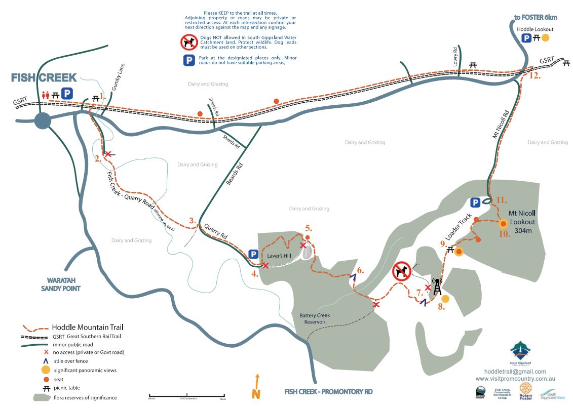
Map of Route
Route Description
Walk the Great Southern Rail Trail east from Fish Creek 400m to the first picnic-seating area at Battery creek (1.). Look for the track to cross the main road to the Fish Creek-Quarry Road.
(2.) This gravel road changes 800m to a grassy track to the right of a private driveway. Take caution: Can be very wet. Sections are gated. Continue walking out onto the intersection of Quarry and Beards Road. Turn right onto the bitumen.
(3.) Walk along this road up to Laver's Hill quarry carpark and entrance. Large quarry trucks use this road section. Just inside the lower quarry gates on your left you meet the walking trail again as a bush track. NB: Strictly NO ACCESS on the Quarry Site.
(4.) The track meanders through regenerating bush of what was once old Fish Creek Gravel Pits. Gentle uphill walking brings you to the upper quarry gravel road access track
(5.) and a seat. Here are views across to the Strzelecki Ranges.
Walk the older gravel access road around the northern side of the quarry, down through a lush bush area towards an old woodshed. Take the stile into the South Gippsland Water Catchment area.
(6.) Continue to the Battery Creek crossing then make continuous steady uphill progress on the gravel road to a small dry dam and the second stile.
(7.) Look for the sign at the fence line. Climb the stile (7.) and walk east up the now grassy old Vic Roads easement towards the Telecommunication Tower. (8.).
At this point you have uninterrupted views south along the Yanakie Isthmus to Wilson's Promontory, east over Corner Inlet to Port Anthony and west over Waratah Bay, Tarwin Valley area and on a clear day Anderson's Inlet, Inverloch.
The trail re-starts from the tower as a gravel road. This leads onto a grassy ridge track (look for red markers) to meet the Loader Track at a group of seats and a table. (9.) The Loader track winds through the Hoddle's diverse indigenous bush flora. There are two seat areas where you can rest and admire the views before reaching the Mt Nicoll Lookout. (10.) and its stunning 360 degree panorama. A compass trig point indicates key places Gippsland places and their distances.
Continue the walking track down to the Mt Nicoll Road car park (11.) Walk right onto the public gravel road downhill to reconnect with the Great Southern Rail Trail. At the final bend before the Foster-Fish Creek Rd look for a walking track at the fenceline and down steeply to the Great Southern Rail Trail. (12.) Turn west to return to Fish Creek (approx 6 km).
Access for Dogs:
Dogs on leads are allowed in most sections of the trail, but are NOT allowed in South Gippsland Water Catchment land.
Location
4 Falls Road, Fish Creek 3959 Map
Web Links
→ Hoddle Mountain Trail Brochure (PDF)
→ Hoddle Mountain Trail, Fish Creek (Walking Maps)
")


")