Euroa - Balmattum Hill Walk

Balmattum Hill walk has great views. There is the option of a 2.6km return walk or a short, easy 600m return walk.
Balmattum Hill Bushland Reserve was established in 1979 and consists of 78.6 hectares of crown land under the management of Parks Victoria. The vegetation community is grassy woodland. White Box is the dominant tree species, with Grey Box, Red Box and Wattles also present.
A range of grasses such as Kangaroo, Wallaby and Spear cover the ground as do lichens and moss and herbs, together with a range of shrub species.
The Balmattum Hill Bushland Reserve is home to many different kinds of native fauna such as birds: owls, parrots, honeyeaters, finches, treecreepers, kookaburras; mammals: microbats, kangaroos, wallabies, wombats, possums, gliders, phascogales; and reptiles: tree goannas, snakes, blue tongued lizards, skinks and geckos.
In addition to the native woodland species, invasive pest plants and animals are also found. Exotic grasses and other weeds such as Paterson's Curse, St John's Wort and Thistle. Pest animals such as rabbits, Indian Mynas and foxes, all compete against native species for the same limited resources.
Granite boulders and rocky outcrops are a prominent landscape feature in the Balmattum Hill Bushland Reserve. Although granite is a hard igneous type of rock, eroding processes over many years caused by weathering has created sheltered habitats amongst the soil and debris at the base of the rock formations. Invertebrates such as ants, centipedes, beetles, crickets, slugs and spiders and other species live here. This in turn is good food for birds and reptiles. This walk can be undertaken at any time of year although summer can be very hot - go early or late in the day and take water and hat.
Location
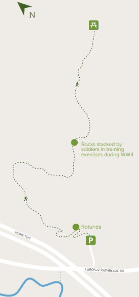
175 Euroa-Strathbogie Road, Euroa. Travel south for 1.75 km on the Euroa-Strathbogie Road (Templeton St) from the Tarcombe St intersection. This intersection is sign posted to Strathbogie. Turn left at the Balmattum Walking Track sign, continue for 120 metres to carpark.
Map of Walk Route
Interactive Map
Walk Options
Short Walk
The track from the car park to the rotunda is about 300m long, offering a pleasant walk with valley views. This section was constructed in 2011 by the Euroa Rotary Club as an extension to the short walk. The extension allowed access to the surrounding bushland, views over Euroa township and across the vast Victorian Northern Plains as far as the eye can see. Rather spectacular!
Long Walk
From the rotunda to the end of the track (close to the summit) is 1036 metres (168 metres of incline). This section was constructed in 2011 by the Euroa Rotary Club as an extension to the short walk creating access to the surrounding bushland and views over Euroa township and across the vast Victorian Northern Plains as far as the eye can see. Rather spectacular! Rock stack - During World War II soldiers physically trained by
carrying rocks up the hill where they remain stacked along the track side.
Both walking tracks are clearly defined and sturdy footwear is advisable. This track links with the Seven Creeks Walking Track (also known as the Apex Track). Seven Creeks is marked on the map.
Location
175 Euroa-Strathbogie Road, Euroa 3666 Map
Web Links
→ Walk Notes - Balmattum Hill Walk (PDF)
→ Balmattum Hill Walk, Euroa (Walking Maps)
")


")