Eldorado Historic Sites Walk


This self-guided tour throughout the town of Eldorado takes you through 31 of Eldorado's mining and commercial sites of the 1850s to 1950s.
The route is shown on interpretive signs displayed on 18 of the sites.
Pick up a map from the Wangaratta Visitor Information Centre at 104 Murphy Street, Wangaratta, download the brochure here or use the map below.
Eldorado Historic Sites Walk Map
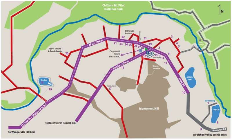
Eldorado Historic Sites Walk Sites
1. El Dorado Primary School Building / The Museum
2. Athenaeum - Rechabite lodge
3. Mc Evoy Mine Shaft No. 3
4. Martell's Albion Hotel - Fealy's Ironmongery and store
5. Cock's Pioneer - Offices and Tin Shed
6. Swing Bridge Mining Embankment
7. Top Cut
8. Cock's Pioneer's first power house
9. Wesleyan Church
10. Mine Locations
11. Sub Station site
12. St Augustine's Church
13. Wesleyan Church
14. El Dorado general store
15. Congregational / Independent Church
16. St Jude's Anglican Church
17. El Dorado Cemetery
18. Cock's El Dorado Gold Dredge
19. Tin Pot Shaft
20. Centennial Park
21. Young's / Milne's butcher shop - Hazelbrook's Cottage
22. Stone Culvert built after WW1
23. Ward's Paper shop
24. Methodist / Uniting Church
25. Schuppe's Bake House
26. El Dorado Memorial Hall - Soldiers' Memorial Hall
27. & 28. Police Station - MUIOOF Lodge
29. Star Hotel
30. Gun House Park
31. Cock's El Dorado Gold Dredging Company NL - Construction site of dredge
Location
136 Main Street, Eldorado 3746 Map
")


")