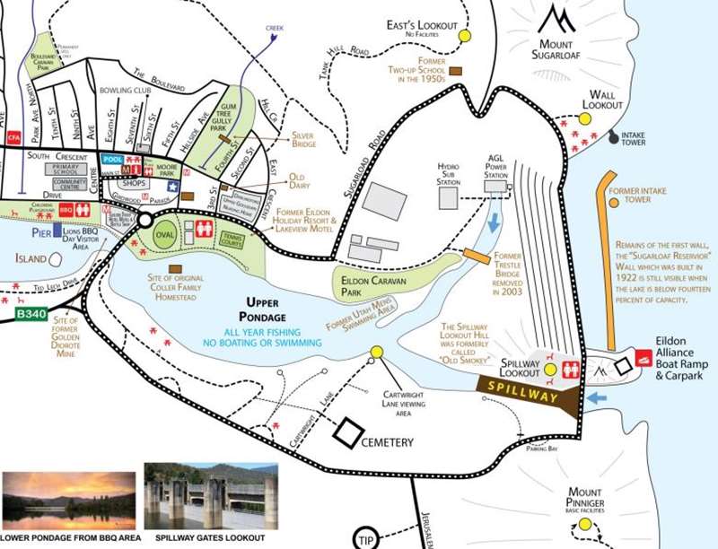
Eildon - Scenic Dam Wall Drive


The Eildon Dam Wall circuit is a 7.3 km drive around the historic "Big Eildon" Dam construction project of the 1950s. It passes the Wall Lookout, Spillway Look-out, Spillway gardens lookout and the Cartwright Lane view. It is also within a few minutes drive of the popular East's Lookout, overlooking the entire wall from a higher vantage point on the north.
As with all lookouts, please stay within the established boundaries. Stopping on the dam wall road is not permitted. Please park your vehicles at the established parking areas, and walk on foot to each location.
The original dam was Sugarloaf Reservoir which was superseded by the much bigger Eildon Dam.
Sugarloaf Reservoir History
Sugarloaf Reservoir was a medium sized dam built at the junction of the Delatite River and the Goulburn River. It was built primarily for irrigation, though was also an important tool for managing river flows and mitigating flooding. When completed, it held over 370 Megalitres.
The dam was constructed by the State Rivers and Water Supply Commission, who managed all State Water assets at that time.
Two sites were considered for the dam. The unsuccessful site was located on the Goulburn River at Trawool. Had this site been the successful one, water would have swamped the townships of Yea, Homewood, Ghin Ghin and Molesworth (as well as others) and the upper bank would have reached as far as the small township of Cathkin.
Work on the Sugarloaf Dam commenced in 1914, with the township of Eildon housing workers and their families. Eildon was then located on the south side of the river, not the north as it is now. During construction, around 250 men were employed at the site.
The Power House was built in 1925 by the State Electricity Commission and was able to generate 15 Megawatts of power when under full load. By early 1928 the Sugarloaf Reservoir was finished, with it being at full capacity on completion.
In April 1929 the wall was damaged by a major rock subsidence. Rock and dirt slipped on the upstream side of the wall causing the top of the wall's core to be exposed, and severely damaged. The concrete infrastructure showed cracks in numerous spots, causing considerable concern in the communities downstream. The slip continued into mid May when repair works finally commenced. The repairs took two years to complete with the wall finally declared safe in 1931 (after it was secured with addition rock
and repairs to the core were finished). As a result of the subsidence, an early warning system was installed for all the areas downstream that would be affected by a mass loss of water at the dam.
Whilst the early warning system was never enacted, it was set off a number of times by lightning and falling tree branches.
The lake went on to become a very popular destination for tourists, fishing, boating and swimming. The lake was also stocked with numerous fish species including the Brown Trout, Rainbow Trout, Perch and Redfin.
The flooding of the new dam meant the township of Darlingford (located on the Big River) was partially submerged. Water also reached within 10 km of the township of Bonnie Doon. Then in 1956 Bonnie Doon was fully submerged as a result of the 'Big Eildon' dam upgrade.
Today the Sugarloaf dam wall can still be seen when the lake falls below 14 percent of full capacity. During these rare times, the best views of the old wall are from Easts Lookout, Foggs Lookout, the 'Intake Tower Day Visitor Area', The Eildon Alliance Boat Ramp and the 'Spillway Lookout' area. Parking is available at all of these locations.
Facts about Sugarloaf Reservoir
- The dam was built by the State Rivers and Water Supply Commission with public money
- The dam wall was built 1914 - 1927
- Works started the year World War I began and built while Australia was at war
- It was built near the intersection of the Goulburn and the Delatite Rivers
- Most work was by manual labour
- There was little mechanical equipment
- There was a steam operated rock crusher
- There were stables for all the horses
- Flooding hindered the construction
- The small township of Darlingford was flooded by the dam
- The high water mark was just 10 kilometres from the township of Bonnie Doon (later flooded by the 'Big Eildon' upgrade)
- Many houses were built for workers and their families whom also lived on site
- Some workers lived in tents
- A school was built for children
- A power house was built as part of the project and generated 15 Megawatts
- The dam was built with a long thin concrete core
- A slippage in 1929 damaged this wall core
- The slippage did not endanger life
- It took a further two years of work to repair the damaged wall
- In 1935 the capacity was increased to 377,000 Megalitres
- The 'Big Eildon' project in the 1950s saw the lake capacity rise to 3,300,000 Megalitres
- The wall is still intact today
- The wall is still visible when the lake falls below 14 percent capacity
The giant American construction company "Utah" was called in to build a much larger dam just downstream of the original Sugarloaf Reservoir after many years of consideration. Holding nearly nine times the water capacity of the original dam, construction of the new wall started mid morning on Friday the 15th of June 1951 with an official political opening when the then Premier of Victoria turned the first sod of soil with a shovel. The new wall cost the community 20 million pounds.
Unlike the former Sugarloaf construction phase which had very little mechanical advantage, UTAH employed all manner of strange large sized machinery. The largest of these being the imported American Euclid truck which achieved in a day what would have taken groups of men months during the previous Sugarloaf wall construction. The dam was built mainly from locally sourced materials, making construction cheaper and quicker as well as keeping many locals employed in the process.
The new spillway was cut through 8 million cubic yards of rock requiring over 2000 tons of explosives to shift the rock. The new spillway is one of the largest of its type in Australia.
The reinforced concrete water chute controlling the water flow as it leaves the three gates high above is 1,370 feet long. It directs and slows the water before it enters the artificially created pondage area
(detention weir). Water was again tunnelled into a large generator via the newly constructed intake tower. This was basically a concrete tower sitting over a large intake hole that funnelled water to the two generators that produced 120 megawatts of electricity for the State Electricity Commissions grid.
Then Premier, the Honourable Sir Henry Bolte officially opened the dam on the 19th of October 1956, marking an end to works that had changed the district.
The new lake covered the old wall with just on 100 feet of water, and created a much more popular tourist location for Melbourne tourists than the previous dam. Fishing, boating and swimming brought people from far and wide. The lake was again home to fish including the Brown and Rainbow Trouts, Perch and Redfin.
In 2001 the turbines at the Powerhouse were upgraded from 120 Megawatts to 135 Megawatts to help meet growing demand and ensure the turbines would continue to run well into the future.
Tourism became the base for the township of Eildon's growth, becoming the centre of a tourism boom up until 1997 when the 15 year drought all but demolished the trade. When water returned in 2010, tourism numbers again began to increase.
Eildon Township was mostly established as part of the Utah Construction phase. Over 300 prefabricated timber homes were erected, each with between four and six rooms. The town itself had Electricity, sewerage and water supply as well as a well designed layout and road system. The shopping centre remains largely the same today as it was built. There was also a modern cinema built, though this has since closed its doors.
The flooding of the dam meant that the old township of Bonnie Doon was now below the water level and
was flooded by the rising waters. Parts of the town were saved by relocating the buildings, though most were left to become part of the legacy of the rising lake.
Today the wall still stands strong and tall and with the end of the drought, water is returning in quickly as is tourism and even locals travelling out to enjoy the beautiful surroundings.
Facts about Eildon Dam
- The dam was built between 1951 to 1957
- It was built just downstream of the older Sugarload Dam wall.
- The tender for the dam was won by an American Company called UTAH
- UTAH imported large machinery for most of the heavy work
- The Euclid was the most recognised piece of machinery used by UTAH
- The dam has a concrete core wall
- Unlike the Sugarloaf Dam, Most of the work was via mechanical labour
- In 2005 the wall was upgraded to lift the standard to worlds best practice, making it safer and more earthquake resistant
- When full the lake holds just over 3,300,000 Megalitres of water
- The small township of Bonnie Doon was flooded by the dam.
- Bonnie Doon township was shifted higher
- The dam was built by the State Rivers and Water Supply Commission.
- Eildon township as we know it today was built by UTAH for the workers and their families. It even had a cinema!
- All town roads were dirt at this stage
- A newer power house was built and 120 Megawatts generators installed
- Over 2,000 tons of explosives were used during the construction phase
Scenic Dam Wall Drive Map
Lookout Points on Drive
WALL LOOKOUT
A lookout with undercover picnic tables. The view includes views of the Intake Tower and along the dam wall.
SPILLWAY LOOKOUT
Take the stairs to the top of the lookout. From here you can see down the Eildon valley, including views of the Eildon township and lower pondage.
SPILLWAY GARDENS LOOKOUT
Take the stairs down to the Gardens viewing area where you will get a close-up view of the spillway. This is especially spectacular when water is being released through the gates.
SPILLWAY ROAD LOOKOUT
Take a walk along the roadway on the spillway to get a true idea of the height of the spillway.
CARTWRIGHT LANE LOOKOUT
Drive to this lookout to get a spectacular view of the spillway from pondage level. This is especially spectacular when water is being released thought he gate system.
There are no facilities at this lookout.
EAST'S LOOKOUT

While not on the circuit, the lookout is only a few minutes drive from the Wall Lookout and offers the viewer an excellent view of the Wall and lake from a high vantage point.
There are no facilities at this lookout.
Easts Lookout is located above the northern end of the Eildon dam wall with the turnoff off Sugarloaf Drive near the Eildon boat harbour. The lookout gives the viewer a lovely view over the Lake Eildon dam wall.
Lake Eildon has over 500km of shoreline when full and this is the main wall that was constructed to hold all the water in. At full capacity the wall hold back 3,500,000 Megalitres of water which is equivalent to over five times the amount of water in Sydney Harbour.
The wall was strengthened in 2007 and 2008 to counter the effects that the drought was having on the internal make-up of the wall. The new rock was once again taken from the Mountain.
Like many lookouts in the area, the full view is now obstructed by trees.
The pondage is part of a larger water regulation process for the Goulburn River. The pondage is best seen as a water holding point before being sent down the river. The Power Station is 120 Megawatt which is enough to supply around 120,000 homes with power. The turbines are driven by water leaving the lake area into the pondage via a large steel pipe.
The township of Eildon was originally built around the construction of the original Dam wall. It has since been a part of all further constructions relating to the lake.
Behind the wall is Mount Pinniger. This is also another look-out and is arguably the best in the district. Behind Mount Pinniger is Jerusalem Creek boat harbour and camping grounds.
There are no seats or tables for tourists to sit on here and the higher fence makes taking in the view less easy. Lookouts are dangerous places, so ensure you stay within the fences & boundaries at all times.
General Directions to East's Lookout
1. Travel to Eildon.
2. Travel to the roundabout at the Golden Trout Hotel Motel and continue East along Eildon Road.
3. Follow the road as it becomes Sugarloaf Drive and follow it up the hill until you reach the top.
4. Continue left along Sugarloaf Drive (which also takes you to the Aqua Cafe and Eildon Boat Harbour).
5. Travel around 400 metres and turn left at the gravel road.
6. Travel 500 metres it up the hill until you reach your destination.
Location
Eildon Spillway Lookout, Embankment Road, Eildon 3713 Map
Web Links
→ Scenic Dam Wall Drive Brochure
")


")