Devilbend Natural Features Reserve (Moorooduc)

.jpg "Devilbend Natural Features Reserve (Moorooduc)")
The reserve includes the largest inland water body on the Mornington Peninsula providing valuable habitat for waterbirds and shorebirds. Recreational activities including picnics, walking and cycling, fishing, photography, birdwatching and non-powered watercraft.
Facilities at the reserve include picnic tables, shelters, toilets and BBQs in the Daangean Point Picnic Area.
The Reserve comprises 422 hectares of native vegetation along with almost 250 hectares of water surface area. The reserve has a number of walking tracks and has all‐abilities access to the shoreline, viewing/fishing platforms and boardwalk.
Things to See and Do
Walking
The features of Devilbend can be explored by selected walking tracks. The trail system includes all‐ability access to the shoreline, viewing/fishing platforms and boardwalk.
The main walks are:
Western Shoreline Track 1.2km return
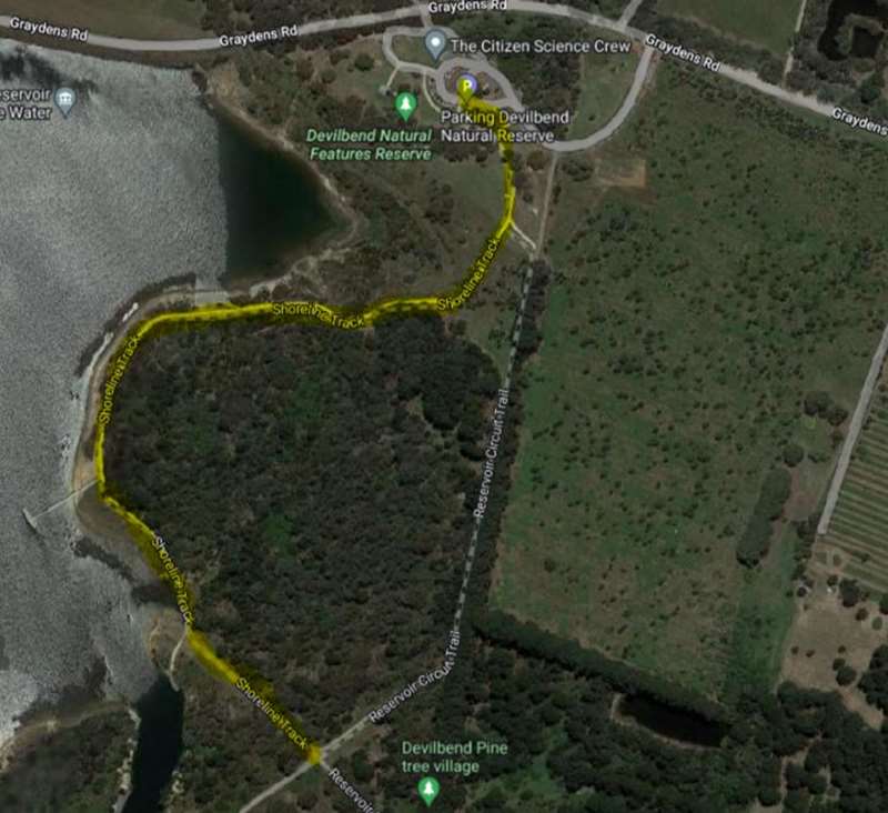
Descend from the Devilbend Picnic Area along the 2.5m wide shoreline trail on a compacted surface that takes in views across the expansive reservoir whilst making your way down to the fishing platforms and boardwalks.
Daangean Point Track 1.5km return
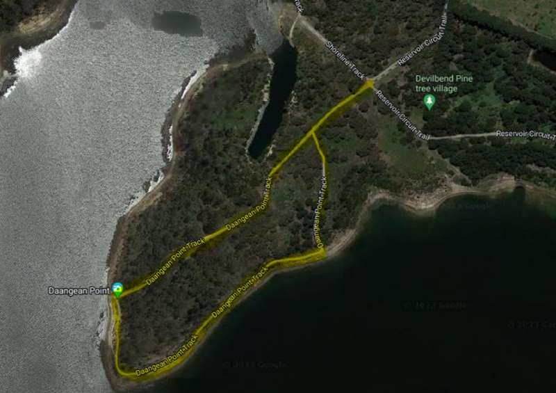
This bushwalk runs through lowland forest from Daangean Point to the southern shoreline. The walk provides expansive views across the reservoir where waterbirds can be viewed.
Devilbend Circuit Track 11.5km - For the more adventurous walker, this 11.5km circuit combines Daangean Trail and the Catch Drain Trail to circumnavigate Devilbend Reservoir. The trail meanders through lowland forest and grassy woodland with multiple access points to the tranquil waterbody providing birdwatching and passive recreation. If you want to extend your walk an additional 2.5km (45 min), Bittern Reservoir Circuit is accessible off the southern end at Hodgins Rd and can be incorporated into the broader circuit.
Horse Riding
A 6.2km, 10m wide horse trail is accessed off Hodgins, Turners or Derril Roads around the Southern Boundary.
Fishing
Devilbend Natural Features Reserve has been stocked with Rainbow Trout, Brown Trout and Estuary Perch making it an ideal inland fresh water fishing body. Fishing is permitted only in the designated fishing zones as identified on the map and needs to be done in accordance with the Victorian Recreational Fishing Guide.
Non‐powered watercraft
A designated zone of 33 hectares, located in the northern arm of Devilbend Reservoir, has been set aside for non‐powered watercraft. Two launch facilities are available by walking along the Western Shoreline Trail. The first is approximately 240 metres from the picnic ground and car park.
Cycling
Cycling is permitted on all trails in the reserve.
Bird watching
Devilbend Natural Features Reserve is of high conservation significance and the 243 hectare Devilbend Reservoir is recognised as an Important Bird Area. This means an area recognised by BirdLife International as being globally important for the conservation of bird populations, supporting over 1% of the global population of the Blue‐billed Duck which is listed as threatened under the Flora and Fauna Guarantee Act 1988. Keep an eye out for the majestic White‐bellied Sea Eagle.
Opening Hours:
The Daangean Point Picnic Area will be open from dawn to dusk, however the park is accessible to pedestrians 24hrs via a small car park located in front of the main entrance gate.
Access for Dogs:
There are no dogs, fires, horses or swimming permitted in the reserve.
Review:
The picnic area has a car park for about 40 cars, toilets, shelter with two tables, BBQs under shelter (2x), 10 partly/unshaded tables, grassy areas dotted with trees and a water tank with some nice artwork.
The best and most interesting walk is to start on the Western Shoreline Track and then connect to the Daangean Point Track and return to the picnic area.
A gravel path leads from the picnic area and splits in two. The right path leads to the Western shoreline and Daangean Point while the left path leads to the Eastern shoreline. There are lots of water birds including black swans on the lake. After crossing a bridge, turn sharply left and go slightly uphill to connect to the Daangean Point track. Then turn right and follow the track through bushland which leads down to the water where there are some seats. Turn left and follow the bank of the lake before the track heads back into the bush and back to the picnic area (900m). The tracks are well signposted everywhere and it is hard to get lost. On the way back we passed a huge area of blackberries but don't eat any because they get sprayed. Opposite the blackberry area are some pine trees where some wooden cubbies have been built.
Photos:
Location
168 Graydens Road, Moorooduc 3933 Map
Web Links
→ www.parks.vic.gov.au/places-to-see/parks/devilbend-natural-features-reserve
→ Devilbend Natural Features Reserve Visitor Guide
")


")