Creek Junction - Cleo's Track

Experience the grandeur of the recently protected Strathbogie Forest on this 7km walk. Descend from dry open woodland into ferny wet gullies and the swampy origins of Seven Creeks. The walk is intermediate to hard. The track is slippery when wet and there are long inclines, some quite steep.
You will be walking an old dirt logging coupe track. In parts dirt bike riders do churn it up. Expect some slippery surfaces and mud in the wet. The return leg is a steady incline with some steep slopes.
It starts in forest and ends in the same forest, but there are different kinds of forest in between. Begin in dry open woodland of stringy bark, messmate and peppermint gum. The first descent is into a blue gum forest as you get deeper into sheltered slopes. Dropping further down, the trees achieve even greater stature, epitomised by incredible mountain gums. Deeper still, explore wet fern gullies where the sun rarely shines. Approaching the bottom, observe increasingly tall blackwood, grand casuarina and white trunked manna.
At the base of the track, a swamp has its own kind of forest. A forest border of gnarled mountain swamp gums surrounds it. This extensive wetland is criss-crossed with rills that form Seven Creeks. Enter at your own risk. Water can be hidden, footing uncertain, sword-grass cuts and snakes live here.
From the bottom, the only way is up. The description above happens in reverse. Inspect a rocky outcrop of stacked granite boulders. Enjoy trees so big they make you wonder, how big were trees here before logging?
Back at the top, your final turn presents a dramatic contrast. After the immersive experience of native forest biodiversity, massive scale monoculture appears. Return to base walking between two very different forms of land use.
Geological history of Strathbogie Forest
The boulder formations and rocky outcrops seen in the Strathbogie Ranges are the result of geological processes that began between 300 and 400 million years ago. After the sea withdrew during the Devonian period, there was a large scale crustal collapse which resulted in two volcanic cauldrons. Eruptions built up large layers of volcanics and the emplacement of granitic rock which has been eroded to the present day to form the Strathbogie Ranges.
Gold was first found in the area in 1851. This was shortly after gold had been discovered in Victoria for the first time. During the gold rush in 1860, alluvial mining occurred on the mountain but the rush lasted only for a short time with the area all but deserted by the end of 1861. Many of the miners headed for Jamieson. At its peak, production of alluvial gold was reportedly around 6,000 - 7,000 oz per annum. Gold production diminished towards the turn of the century and only small operations continued.
Quartz crystal has also been mined in the Strathbogies and two crystal mines are still operational within the forest. The crystal is used for piezo-electric applications including radio transmitters. The largest hand cut crystal in the world, the 1.7kg 'Crystal King', was mined in the Strathbogies. Unfortunately, visitors are not permitted into the crystal mines.
Location
Corner of Cleo's Track and Bonnie Doon Rd, Creek Junction 3669. From Euroa, take the Euroa-Strathbogie Rd to Creek Junction Rd. Drive all the way to Bonnie Doon Rd and turn right. At the intersection with Police Track, turn right to continue along Bonnie Doon Rd for 500m. Park in the entrance to Cleo's Track on the right. There is a sign opposite.
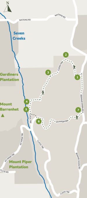
Map of Walk Route
Interactive Map
Track Notes
1. Begin your descent - Messmate, red stringy bark and peppermint gums dominate the drier high ground of the forest here.
2. Bluegums and mountain gums appear - As you walk lower there is more moisture in the ground and a cool humidity in the air. A transition to different species changes the character of the forest.
3. Fern Gully - Deviate for a short distance to experience the atmospheric change as you encounter the cold air
above cold running water in a sheltered fern gully hollow never warmed by the sun.
4. Seven Creeks Swamp - Seven Creeks gets its name from the seven different creeks that rise here in the Range to form its headwaters. In this place it consists of rills crisscrossing a swampy sword grass wetland.
5. View to Mt Barrenhet - Swamp gums create a wetland border. You can cross this to climb Mt Barrenhet. Be warned though, it is a significant extra undertaking. If you intend to do so, skirting the swamp first is a good idea.
6. Rocky outcrop - Immediately opposite Cleo's Track at the junction with Mt Piper Track, this moss capped group of granite boulders invite exploration.
7. The forest meets the pines - Emerging from immersion in an ecosystem wonderland to suddenly confront a pine plantation may be a jolt. Take the opportunity to compare and contrast as you appreciatively walk between them to base.
Camping
Camping is permitted. There are no toilets and no potable water. Take your rubbish with you, campfires are prohibited on days of Total Fire Ban and vehicles / motorbikes must be registered, drivers licenced, use formed roads only.
Access for Dogs:
Dogs must be under direct control at all times and leashed when near other people.
Location
Cnr Cleos Track and Bonnie Doon Road, Creek Junction 3666 Map
Web Links
→ Walk Notes - Cleos Track (PDF)
→ Cleos Track, Creek Junction (Walking Maps)
")


")