Chewton - Garfield Water Wheel


The Garfield Water Wheel historical site has the imposing stone foundations of the huge wooden 22 metre diameter wheel that powered the Garfield Mine's crushing battery. After its construction the Garfield Water Wheel was hailed as the largest in the southern hemisphere.
The water wheel was used to power the stamp battery for the mine.
This area is the middle of what was once the Garfield Mine. All around are traces of gold mining, hidden among the trees.
When prospectors first arrived in the 1850s, they panned and dug in the creeks looking for flecks of gold that had washed down from the hills and settled in the soil and gravel (alluvial gold). Then they followed the creeks up into the hills, looking for the quartz reefs the gold had come from.
Finding the reefs wasn't as challenging as getting the gold out of the quartz. At first, they chipped away at it by hand, or used hand or horse-powered machinery to crush the quartz to powder. It was slow, back-breaking work. Miners began to team up and form companies to build crushing batteries. These used heavy steam-powered hammers to crush large amounts of quartz. They burned huge amounts of wood, and by the 1880s, there was barely a tree left on the hills around.
Water was scarce on the goldfields until the construction of the Coliban Water Race in the 1870s provided a reliable water supply.
With timber increasingly scarce and expensive, water wheels were a great alternative source of power for the batteries. More than two hundred were built across Victoria. The Garfield Water Wheel was the largest of them all. The Garfield Company (later known as the Forest Creek Gold Mining Company and then Chewton Gold Mines) operated from 1882 to 1912, employing up to 90 workers. The main shaft was located 150m to the north of the water wheel.
Enjoy a short family-friendly walk around the former mine and surrounding bushland on the Garfield Mine Walk (walk 1, 500m circuit, 15mins) and Garfield Bush Walk (walk 2, 400m circuit, 10mins). Look out for interpretive signs around the wheel and trailhead. Discover even more of the area's mining history on one of the longer self-guided loop walks that lead to the Monster Meeting Site (walk 3), Pennyweight Flat Cemetery (walk 4), Quartz Hill (walk 5) and the Welsh Village and Nimrod Reef Mine (walk 6). All start from the Garfield trailhead and are Grade 3 walks ranging between 3-6.5km on gravel and earth tracks with gentle to moderate hills.
Location: The access road is unsealed but suitable for 2WD vehicles including coaches. Garfield can also be accessed by foot or bike via the Leanganook section of the Goldfields Track (stop LT04).
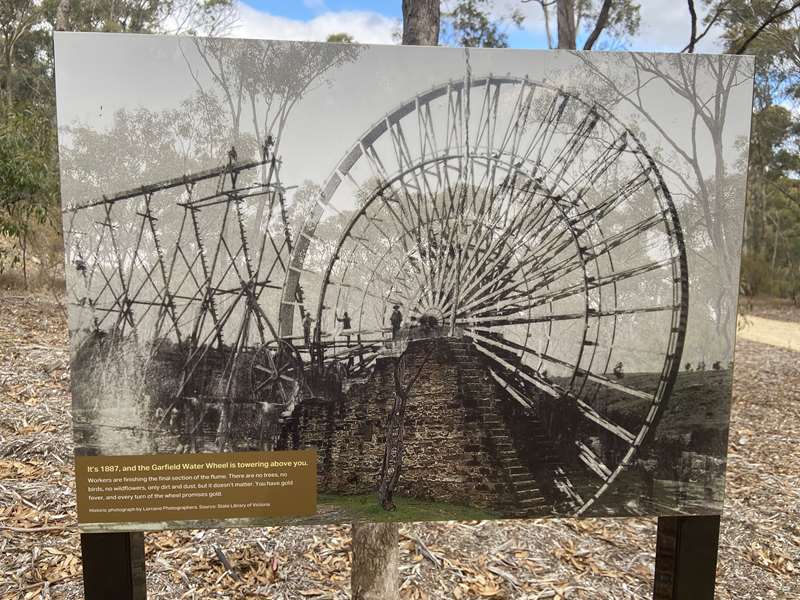
The Garfield Water Wheel, a giant on the horizon
It's the late 1800s, and you're driving your horse-drawn buggy down the Chewton-Castlemaine Road.
Few trees remain to block your view in this intense mining landscape. You see a large water wheel on the horizon, its bright blue spokes and jet-black iron bands slowly rotating. At 21 metres high, it is the biggest water wheel in the southern hemisphere and impossible to miss.
Most of the machinery used to extract gold from quartz in the 1850s-1930s is powered by steam. Here at the Garfield Mine, their power source is different - and eye catching.
The rim of the wheel is lined with 220 buckets. Water is carried to the buckets on a wooden flume (a raised open channel). It is 240 metres long and stands 17.5 metres tall at its highest point.
The weight of the buckets pulls them downwards, forcing the wheel to rotate backwards. Gears attached to the wheel move the stampers that crush quartz to release the gold within. There are 15 stampers in the battery, hammering all day, all night, 6 days a week.
The deafening stampers fall silent on Sundays, but the wheel never stops turning. This helps to preserve it from drying out and warping.
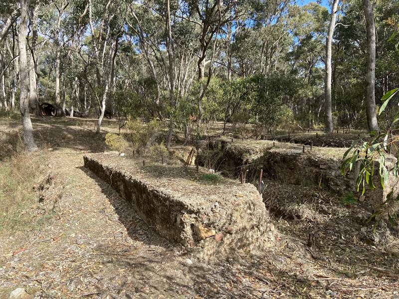
The Garfield Water Wheel was built in 1887 and operated almost continually until 1904. The wheel pivoted atop the 10.5 metre high walls that you can still see today. To create space for the giant wheel to turn, the tough rocky ground between the walls was excavated to a depth of 3.6 metres.
Water was diverted to the wheel from the Coliban Water Scheme. This ambitious project involved damming the Coliban River, building reservoirs, and digging 70 kilometres of water races, tunnels, and channels to supply towns and mines on the goldfields between Kyneton and Bendigo. It still operates today.
In 1891, Ada, the four-year-old daughter of Garfield Mine manager, John Ebbott, caught between two spokes of the wheel. She is saved, but her face remains forever slightly twisted. Her grandfather is less lucky. Two years later he is crushed to death by the mighty water wheel.
There's gold in these hills. How did it get here?
Imagine what the earth was like 440 to 360 million years ago, 200 million years before the dinosaurs, around the time of the earliest fish and land animals. Australia was part of the supercontinent of Gondwana, located close to the equator. The climate was warm, and Australia was covered in shallow seas full of corals. Plants were evolving to cover the previously barren landscape.
It was a time of geological unrest, with many volcanoes active across what is now Victoria, and many cracks (or faults) opened up in the Earth's crust. Water flowed into these cracks, and under intense pressure, the minerals it carried, like gold and quartz, formed reefs or lodes.
Most of Victoria's gold comes from these quartz reefs. As wind and rain eroded the softer sandstone around them, the harder quartz was often left exposed as white hills. Over thousands of years, bits of quartz and gold washed down into the creeks to eventually be found by prospectors. They followed the creeks up into the hills, looking for the reefs the gold came from.
And how do you get it out?
Finding gold is one challenge - getting it out of the quartz is quite another! First, you have to get the quartz out of the ground. If it is near the surface, you can start chipping away at it with picks. If it's below ground, you need to dig a shaft (to get at the gold from above), or an adit (tunnel in the side of a hill). Then you need to remove the quartz and crush it to a fine powder to extract the gold.
Initially, this was done by hand with hammers or using horse-powered crushing machinery, but it was slow and back-breaking work. Steam-powered crushing (or stamping) batteries were more efficient and soon became widely used. A boiler and steam engine powered a series of pulleys and straps that operated heavy iron hammers which pounded the quartz. However, they required a regular supply of wood to burn in their boilers, which was labour intensive and caused deforestation.
By the 1880s, timber was hard to find and expensive to buy. There was an alternative - but it required a steady supply of flowing water.
Where did the water for the wheel come from?
Water was scarce on the goldfields, and in the early days of mining, work often had to stop due to shortages. This changed with the construction of the Coliban Water Scheme in the 1860s-1870s.
This incredible feat of engineering was designed by Mr Joseph Martin Brady, a civil engineer from Ireland, who proposed the scheme in response to a competition launched by the Victorian Government to provide a reliable water supply to the mines and farms of the central goldfields.
His system of water races (channels) took almost a decade to plan and construct, but when completed, carried water from newly created reservoirs to the mines. The channels follow the contours of hills, dropping only a few feet per mile. Gravity ensures a steady but controlled flow of water along the gentle slope. Parts of this extraordinary Victorian Heritage-listed system still operate today.
Although it is only 2.5km from here to Expedition Pass as the crow flies, this race has travelled over 7.5km around the hills.
A revolving solution to a crushing problem
A reliable supply of flowing water meant that water wheels could be used to power the crushing batteries instead of steam. Replacing a steam engine with a water wheel saved money and manpower, and they quickly became popular. More than two hundred were built across Victoria, including several in this area, but the Garfield Company's, constructed in 1887, was the largest.
With a diameter of over 21m and 220 buckets, it was one of the largest in the world, and could be clearly seen from the Chewton-Castlemaine road. At that time, most of the trees in the area had been chopped down for fuel and construction. The forest you see now has regrown naturally since then.
A deep pit was dug into solid rock and two walls, nearly 12m high, were constructed from large blocks of sandstone. The central hub of the wheel rested on top of these walls. The spokes (arms) were made of wood painted light blue, and secured to three circular bands of iron painted black. The 220 buckets fixed on the wheel were just over 24cm wide and made of galvanised iron.
The Coliban Water Race brought water to a nearby hill, and then it was carried along a 241m wooden flume (aqueduct), supported by huge trestles (6-18m high), before falling into the buckets on the rear of the wheel, causing it to rotate backwards. A full revolution took 45-55 seconds.
It was an efficient process, with only a quarter of the water carried along the race needed to power the wheel, which was then diverted to another water wheel and reused.
The crushing battery was housed in a corrugated iron building next to the wheel. The rotation of the wheel transferred power to the machinery, including eighteen heavy iron stampers (hammers) that crushed the quartz to a sand-like powder, releasing the gold within.
The water wheel operated almost continuously from 1887 to 1904, turning even on Sundays, when the battery fell silent, and miners took the day off.
After turning the Garfield Water Wheel, the same water continued down the race to drive the water wheel at the Manchester Mine operated by the Wheal Margery Company. Its wheel was smaller and older than the one at Garfield.
The wheel eventually proved to be too big for its own good. Wear and tear plus difficulty in high winds, caused the wheel to be decommissioned in 1903 and dismantled in 1904. The battery was converted to steam-power.
The Garfield Company and successors
The Garfield Mine was one of many in the area that mined the local quartz reefs. The Garfield Company (later known as the Forest Creek Gold Mining Company and Chewton Gold Mines) operated from 1882 to 1912.
By 1885 it was employing around 70 workers. The Company was so successful that it was able to purchase shares in several additional mines nearby.
The mineshaft that supplied quartz for the battery, was located 150m to the north of the wheel. The quartz was transported to the battery via a tramline. This was built with a very gradual slope so that the heavy trolleys of quartz could be easily and safely pushed down to the battery, and the empty carts could be pushed back up to the shaft.
Who kept the wheel turning?
The Garfield Mine was managed by John Ebbott, a Cornishman whose family migrated to Victoria in 1852. They settled in Bendigo, where John married Margaret Thomas, the daughter of a mine manager. His interest in mining took him to New Caledonia and India where he learned how to operate water wheels.
John Ebbott oversaw the mine's operation from construction right through to its closure in 1912, when the machinery was sold off. John and Margaret, who lived in a cottage overlooking the tramline with their eleven children, lifted the timber section of their home onto a dray and re-located it to Chewton.
One of their children had a very lucky escape. One Sunday, the only day of the week that the mine did not operate, their daughter Ada climbed to the top of one of the water wheel's walls, and got her head stuck between two of the spokes.
She was rescued, but her face was slightly twisted in the ordeal and noticeable for the rest of her life. However, Ada lived to the grand age of eighty-four, a long life for that time, married and raised a family. Sadly, her grandfather was not so lucky. He was crushed to death by the water wheel only two years after Ada's accident.
Walks from the Garfield Water Wheel
The Garfield Water Wheel is a trailhead gateway to the Northern Diggings area. There are six self-guided walks which are sign-posted with trail numbers from the Garfield trailhead including two short circuit walks.
These circuit walks may be walked in either direction, however we strongly recommend following the directions suggested on the maps and signs which corresponds with the order of features interpreted in these notes. At track junctions, look for the number of the walk you are on, as shown in the map and descriptions.
(1) Garfield Mine Heritage Walk
Grade 2, 500m circuit, 15mins.
Gravel and earth track. Gentle hills.
Starting from the Garfield trailhead, this short circuit walk explores the Garfield Mine. Numbered posts correspond with the information in the heritage notes and on the sign at the trailhead.
(2) Garfield Bush Walk
Grade 2, 400m circuit, 10mins.
Gravel and earth track. Gentle hills. Heritage notes available.
Starting from the Garfield trailhead, this short walk meanders through the bush offering you a taste of the Box-Ironbark forest.
(3) Monster Meeting Site Walk
Grade 3, 5.5km loop, 2hrs.
Gravel and earth track. Gentle to moderate hills. Some bushwalking experience recommended. Heritage notes available.
This loop walk takes you from the Garfield trailhead down to the site of Monster Meeting, where 15,000 gold diggers met in December 1851 to protest an increase in the mining licence fee. Explore well-preserved gold mining features and enjoy great views over Chewton and Forest Creek from the Burns Hill Lookout along the way.
(4) Pennyweight Flat Cemetery Walk
Grade 3, 6.5km loop, 2-2.5hrs.
Gravel and earth track. Gentle to moderate hills. Some bushwalking experience recommended. Heritage notes available. Rated blue (moderate) for mountain bikes.
This loop walk explores several mining features between the Garfield trailhead and the Pennyweight Flat Cemetery, where dreams of success on the goldfields came to a sad end.
(5) Quartz Hill Walk
Grade 3, 3km loop, 1-1.5hrs. Gravel and earth track. Moderate hills, some steeper sections. Bushwalking experience recommended. Heritage notes available.
Trace the path of prospectors who followed the gold up through the gullies into the hills. Starting from the Garfield trailhead, this loop walk explores the upper reaches of Sailors Gully and Quartz Hill.
(6) Welsh Village Walk
Grade 3. From Garfield trailhead: Grade 3, 5km loop, 2- 2.5hrs. From Welsh St carpark: Grade 3, 1.2km loop, 45mins. Moderate hills, some steeper sections. Bushwalking experience recommended. Heritage notes available.
Step back in time amid the atmospheric ruins of the Nimrod Reef Mine and Welsh Village, an abandoned goldrush settlement, and learn about Dja Dja Wurrung Culture before and during the goldrush. To preserve the unique heritage of Nimrod Reef and Welsh Village, dogs and bikes are not permitted beyond the carpark on Welsh St, and there is limited signage.
(1) Garfield Mine Heritage Walk
Grade 2, 500m circuit, 15mins
Gravel and earth track. Gentle hills, a few slightly steeper and rocky sections. No bushwalking experience required.
Starting from the Garfield trailhead, this short circuit walk explores the Garfield Mine Site. Numbered posts along the way correspond with the notes below.
From the trailhead, follow the (1) Garfield Mine Heritage Walk signs north. The path briefly follows the same track as the (5) Quartz Hill Walk and the (6) Welsh Village Walk, before turning east.
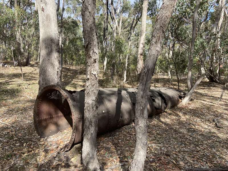
As you leave the trailhead, you are passing close to where the mine manager, John Ebbott lived with his wife Margaret and their eleven children. The Ebbott's five-room timber cottage was located beside the tramline used to move quartz from the mineshaft to the wheel-powered crushing battery. As you approach Stop 1 you can see an iron chimney stack lying to your right, part of the New Garfield Company's plant in the 1930s.
Stop 1
The Garfield mineshaft - plumbing the depths for riches
To the left of the track is the Garfield Mine's main shaft. At 346m deep this is almost 50m deeper than the height of the Eureka Tower (Melbourne Skydeck)!
To the right of the track are some concrete blocks. These supported the machinery that lifted the quartz out of the shaft and pumped water out. The iron chimney stack was connected to the boiler. These relics are from the New Garfield Company, founded in 1937.
The original Garfield Company removed and crushed 132 million kilograms of quartz from this shaft, yielding 1,042kg of gold. The New Garfield Company, was not as lucky. It was unable to secure water from the government-run water race and work stopped several times. It closed in 1943, during World War II.
Stop 2
Mullock heaps - reminders of intensive labour
The many small holes and mullock heaps on both sides of the track show how intensively this area was worked by diggers.
Alluvial gold mining methods use a combination of water, movement and gravity. Swirl the soil and water around until the soil breaks apart and the heavier gold sinks to the bottom. Miners would dig holes, wash the soil, remove any gold, then discard the soil in mullock heaps. Common techniques included:
- Panning - swirling very small amounts of water and soil around by hand in a dish.
- Cradling - rocking small amounts of soil and water back and forth in a wooden box similar to a child's cradle.
- Puddling - stirring larger amounts of soil and water in a round tub or ditch, using paddles or rakes pulled by hand or horse. You can see the remains of a puddler on the (5) Quartz Hill Walk.
- Sluicing - diverting water to wash anything from small amounts to enormous quantities of soil.
Sluicing channels - washing away the dirt
To the right of the track here you can see a small trench which channelled water from the nearby dam for sluicing. There is another trench on the left of the track a little further on.
Sluicing was more efficient than other alluvial gold mining methods, allowing larger quantities of soil to be washed, but it also required more water. Before the water races, sluicing was only possible when there was enough water in the creeks and dams. Work on the goldfields often came to a stop in droughts or over summer.
The sluicing here was small-scale, but in the 1890s, hydraulic water cannons were used to wash huge amounts of soil away from creek banks, creating dramatic cliffs. You can get a glimpse of this in the gully to the left of the road as you drive back towards Chewton, but there are other sites nearby that offer better views.
Between stops 3 and 4 the path turns left along an unsealed road, before leaving the road at stop 4.
Stop 4
The Coliban Scheme - slow and steady wins the race
Between stops 4 and 5 the track follows the channel that brought water from Expedition Pass Reservoir to mines in this area. During the goldrush, mining often had to stop due to water shortages. So, the Victorian Government offered a prize to anyone who could provide a reliable water supply to the mines and farms of the central goldfields.
The construction of water races across hundreds of kilometres of Central Victoria took almost a decade. It was an extraordinary feat of engineering without the benefit of modern maps, GPS equipment or laser levels.
This incredible system of water races was designed by Joseph Martin Brady, a civil engineer from Ireland. The channels follow the contours of hills, dropping only a few feet per mile. Gravity ensures a steady but controlled flow of water along the gentle slope. It took almost a decade to plan and construct. From here to Expedition Pass is only 2.5km but the water travelled over 7.5km on this slow race around the hills.
Stop 5
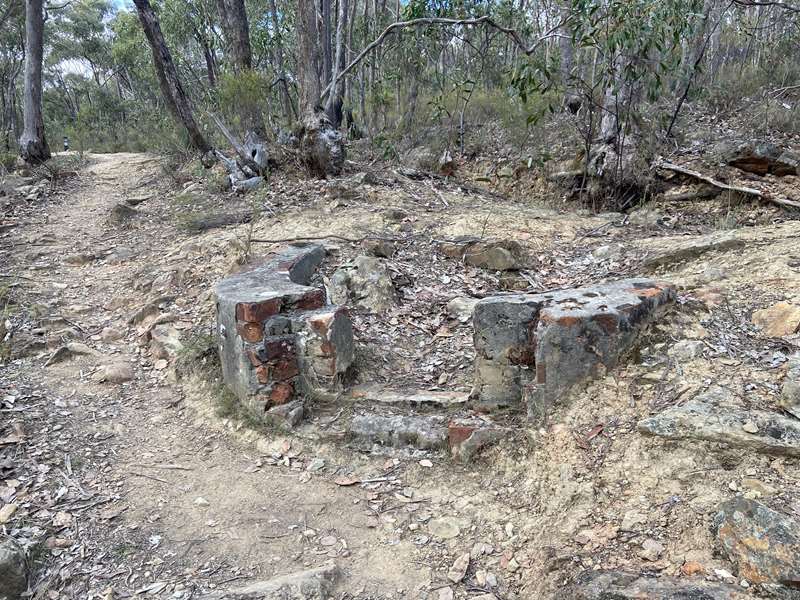
The flume - taking water to dizzying heights
The small semi-circular stone structure on the water race here is the point where water was diverted along a flume, a raised wooden channel like an aqueduct, to the wheel. The flume was 241m long and supported by trestles ranging from 6-18m high.
Look downhill following the line of the path before it turns left, and then look up into the trees. You should be able to glimpse the stone foundations that supported the centre of the water wheel through the trees. Can you imagine what the flume would have looked like from this angle?
The next section of path is rocky and uneven and involves a moderately steep descent for a short distance. To the right of the path is a large dam.
Stop 6
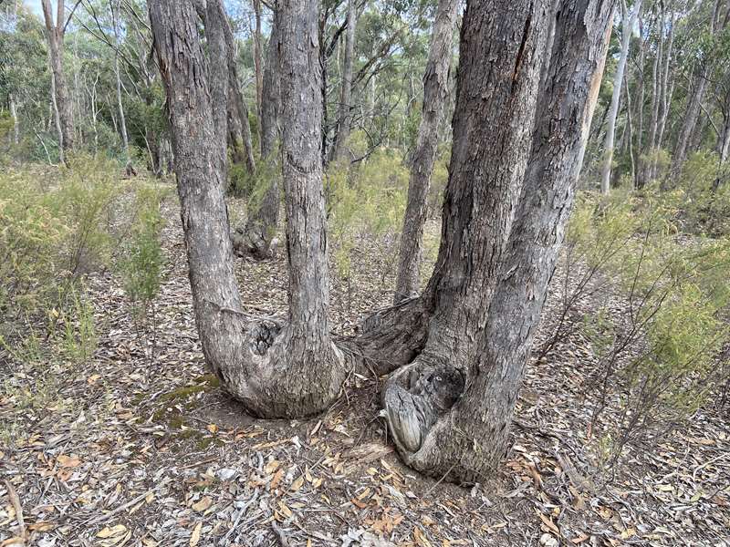
Coppiced trees - survival and transformation
Look around you at the trees. They are mainly box species. Like the example here, you will see that many have multiple small trunks, often around a central stump. This is known as coppiced regrowth, and is a remarkable story of survival, transformation and regrowth.
Many Australian trees have a type of swollen root called a lignotuber, that allows the tree to regrow after fire - or being chopped down during the goldrush. All the trees in this area have regrown after being harvested for fuel and timber.
Continuing along the path towards the foundations of the wheel, you can see a channel at the point where the flume ended. This would have collected any water that spilled over from the buckets.
Stop 7
The crushing battery - shattering quartz and peace
Continue along the path and stop at the bottom of the steps beside the wheel foundations. There is no numbered post here.
This is where the Garfield Company's crushing battery stood, housed in a corrugated iron building next to the wheel. The battery also crushed quartz for the neighbouring Louisa James Company, which the Garfield Company bought a share in.
Nothing remains of the battery now. The ground beneath it began to subside in 1886, and it was relocated further south. Reports suggest that the wheel and flume were also relocated. It was a mammoth undertaking that stopped work for about six months. When the mine closed in 1912, all the equipment was sold off.
The machinery inside the shed would have looked something like the illustration below. Eighteen metal stampers (heavy hammers that looked like organ pipes each weighing over 200kg) were powered by a system of wheels and pulleys driven by the turning of the water wheel.
Quartz was tipped into the battery from the raised tramline and pounded to sand by the stampers. The battery sand was mixed with water into a slurry and forced through mesh screens onto the sloping aprons or concentrating tables (also known as blankets). These were covered by copper sheets coated with mercury, which caught and amalgamated with the gold.
Periodically, the gold-mercury amalgam was scraped off the copper sheets and heated to vaporise the mercury and release the gold. Once cooled, the mercury was reused.
The miners involved in this process would probably have suffered from mercury poisoning. Mercury is a neurotoxin which damages the part of the brain that co-ordinates movement. It also harms the kidneys and other organs.
Although it is illegal to use mercury in gold mining in many countries today, there are an estimated 10-15 million unregulated gold miners operating in 70 countries. About 15% of the world's gold is produced by small-scale miners. Mercury is still widely used, causing irreversible neurological damage to workers.
Traces of mercury, arsenic and cyanide can still be found in mullock heaps and mine tailings across the Victorian goldfields, but pose little danger if not disturbed.
The Garfield Company crushed 136,468 tons (132 million kg) of quartz from this one shaft alone, yielding 33,518 troy ounces (1,042kg of gold). Enough to make 208,400 wedding rings or sell for around AUS $83 million in 2022.
Can you imagine what it would have been like to work here, among the quartz dust and the mercury and the deafening noise? The battery operated 24 hours a day, 6 days a week, making a deafening noise. The water wheel turned almost continuously from 1887 to 1903, even on Sundays when the battery fell silent. In 1903, the wheel was replaced by a steam engine which offered more crushing power, and an increase to twenty-five stampers.
From here, you can return to the trailhead or carpark, or continue on to the (2) Garfield Bush Walk which starts on the opposite side of the clearing.
(2) Garfield Bush Walk
Grade 2, 400m circuit, 10mins
Gravel and earth track. Gentle hills, a few slightly steeper sections. No bushwalking experience required.
This short walk meanders through the bushland, giving you a taste of the surrounding Box-Ironbark forest.
Starting from the trailhead, look for the sign marked with a (2) on the opposite side of the clearing and follow the short well-marked path which re-emerges near the water wheel.
On both sides of the path you can see the evidence of mining, including shafts, mullock heaps and small trenches and channels. The path slowly descends into a gully, where the battery sands (mine tailings) from the crushing plant were dumped, before climbing back towards the foundations of the water wheel.
From winter through to spring, gold returns to these hills when the wattles flower, including Golden Wattle, Spreading Wattle and Silver Wattle (there are several of these overhanging the path in the gully). Look out for a large Cherry Ballart on your left about half-way around the path. Known as Baiatj in Dja Dja Wurrung language, it is a culturally important plant for its many uses and resources.
Spring wildflowers, including lilies, daisies, and orchids, are usually at their best between September - November, but Sticky Everlastings dust the forest with gold well into summer.
The forest floor is at its greenest after autumn and winter rains, when moss, fungi and lichen flourish. The closer you look, the more you begin to notice.
With different trees flowering through the year, there is always nectar to attract birds. Over 100 species of birds have been recorded in the area.
Walk slowly and be sure to look up, down, and all around. What can you see, hear and smell?
The recovering forest
How many coppiced trees - trees with multiple trunks around an old stump - can you see?
During the gold-mining era, most of the trees in this area were felled to support both mining and a growing population. Wood was needed for buildings, scaffolds, braces, headshafts, tramlines, trolleys, wheels, handles, tubs and cradles, to burn in quartz kilns (roasting made the quartz brittle and easier to crush) and boilers to generate steam for crushing plants. It was needed for homes, shops, churches, furniture, horse-drawn carts, cooking and warmth.
The felled trees have regrown multiple trunks around their stumps from lignotubers. What looks like many trees, may actually be just one. This make the forest look denser than it was originally.
Stop for a moment and imagine what the area might have looked like before the goldrush. The forest would have been more open with more big old trees with single trunks up to 2m in diameter.
Tree hollows would have provided dens for possums and Brush-tailed Phascogales (Duan) and nest sites for birds. Small hollows may take seventy years to develop, and large hollows even longer, as branches break away and wood slowly begins to decay.
Few hollows have been able to develop yet in the recovering forest, presenting a challenge for the animals that rely on them. In many areas around Castlemaine and Bendigo, community groups are helping things along by placing nest boxes in the trees. Recovery is slow, but steady.
Access for Dogs:
Dogs may be walked on a lead on the tracks around the Garfield Water Wheel. They must be kept on a lead and under control at all times. Please collect and remove your dog's droppings for the sake of other visitors and to avoid stress to native animals.
Safety:
The Castlemaine Diggings are a heavily mined landscape and contain a variety of ongoing hazards, including uneven and unstable ground, mineshafts, open cuts, quarries, and mine tailings. For your own safety, please stay on mapped tracks and supervise children. Comply with local signs and do not climb over or around barriers and fences or on the stone foundations of the water wheel.
Photos:
✆ Chewton
Web Links
→ www.parks.vic.gov.au/places-to-see/sites/garfield-water-wheel
→ Garfield Water Wheel Heritage Notes (PDF)
")


")