Centennial Park Dog Off Leash Area (Macedon)

.jpg "Centennial Park Dog Off Leash Area (Macedon)")
Centennial Park consists of grassed areas, water tap with bowl, shelter with BBQs, toilets, bins in a number of places, tables, information bay and touring map. There is also an Ash Wednesday Memorial, stone sculptures representing the area, and mosaic statues reflecting the history of the district.
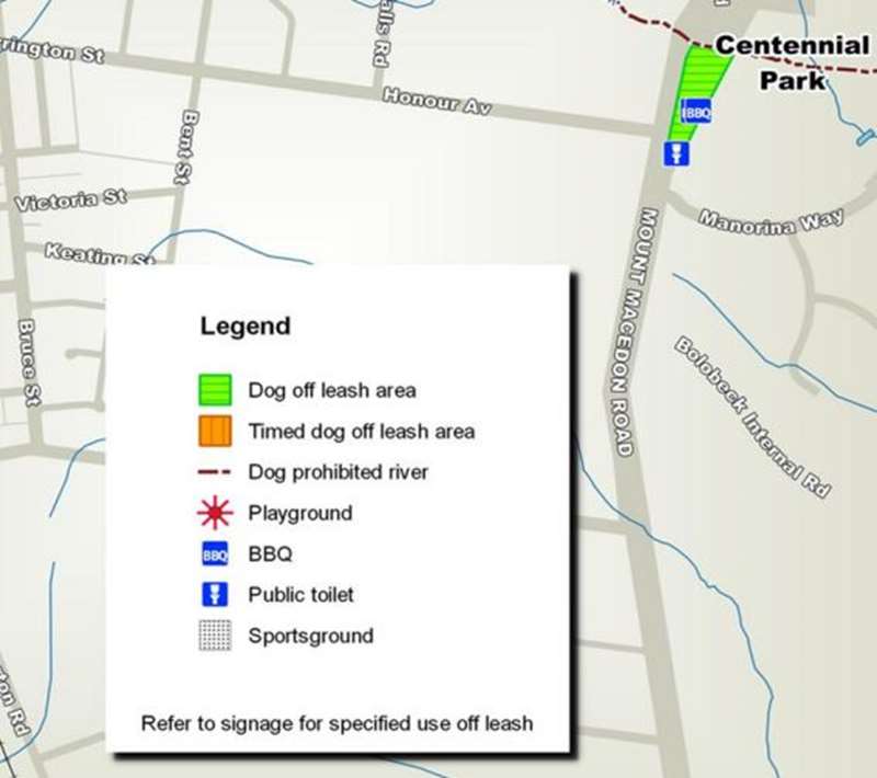
The park is a dog off-leash area at all times.
It is a beautiful spot with a gravel path with wanders through the area lined with shady trees. There are some shaded tables beside the path. The park is about 150 x 50m in size and located beside Mt Macedon Road. The park is so nice and has a lot of facilities, so it can get very busy with people.
Map of Dog Off Leash Area
Information Panel at Site
First Peoples and Hanging Rock
Hanging Rock was created 6.25 million years ago by stiff magma pouring from a vent and congealing in place. For thousands of years Aboriginal custodians cared for the 'Rock'. Over the last 150 years, both visitors and its image makers preferred to picture it as 'natural' - a wilderness rather than a cultural landscape. Finally, in the 21st Century, the Aboriginal custodians of Hanging Rock have been acknowledged in arrangements for managing the Reserve. The lands surrounding Hanging Rock were occupied by the networks of the Wurundjeri, Dja Dja Wurung and Taugurang clans.
1824: Mount Macedon and the Great Dividing Range
Mount Macedon is a dormant volcano and forms the southern end of Victoria's Great Dividing Range. Rising to 1000m, along with the Camel's Hump, it is the most prominent feature of the Macedon Ranges. The mountain was sighted by Hamilton Hume and William Novell on their 1824 expedition. They named it Mount Wentworth. It was renamed Mount Macedon by explorer Major Thomas Mitchell (the Surveyor General of New South Wales), on 30th September 1836 at which time he noted the high quality and size of the timber.
Late 1830s: Early Settlers
From the late 1830s, many pastoralists took up tracts of land in surrounding districts, arriving from Tasmania and New South Wales. Victoria's first sawmill was established nearby, providing much of the timber needed to develop the new colony. Other sawmills were established throughout the mountain ranges. This industry provided timber for dwellings and commercial buildings both locally and in Melbourne, for fencing, lining for gold mines, and for railway sleepers and the construction of the Railway Station.
The sawyers and splitters employed at the mills lived in huts in the surrounding forest. Other early settlers established eucalypt distilleries and charcoal retorts, utilising timber by-products, as these industries required little capital to establish. Both brick and tile making became successful local industries in the development of this district, while some settlers tried their luck with slate and gold mining, but with limited success.
1851: Gold
In 1851, when gold was discovered at Castlemaine and Bendigo, Middle Gully developed, later renamed Macedon. This fledgling township provided inns, beer houses, coffee tents, blacksmiths' forges and stores to supply the needs of traveller. ln one week, over a ton of gold was conveyed through Macedon on route to Melbourne. Construction of the railway in 1861 brought many workers and their families to this district. At the villages of Middle Gully and Macedon Upper, hotels, churches and schools were built to meet the needs of these growing communities.
1870s: Logging
By the early 1870s the timber industry had denuded the mountain to such an extent, the Government established the Macedon State Nursery, to encourage replanting of the mountain and to supply seedlings throughout the colony. For many decades, this nursery employed numerous gardeners and former timber industry workers. Many trees propagated at the State Nursery were English varieties with which landowners were familiar; hence the unique character of many early plantings in the streets, parklands and private gardens in this area.
1900s: The Hill Stations
To take advantage of pure mountain air and to escape Melbourne's hot summers, wealthy businessmen purchased substantial areas of land and built large family homes at Upper Macedon. With the popularity of the motor car, the wealthy were able to travel greater distances than Mount Macedon, so many homes were converted to guest houses with local residents providing the gardeners, caretakers and domestic workers. Mount Macedon district developed as a popular tourist resort and continued until after World War II, when many blocks were subdivided and some guest houses reverted to private homes.
16th February 1983: Ash Wednesday Bushfires
More than 180 fires fanned by hot winds of up to 110 km/h (68 mph) caused wide-spread destruction across Victoria and South Australia. The fires raced uncontrollably up the slopes of Mt Macedon and, despite the efforts of 1000 volunteer firefighters, it killed seven people, burned 30,000 hectares of forest and farmland, and over 400 homes.
Photos:
Location
Mount Macedon Road, Macedon 3440 Map
Web Links
→ Macedon and Mt Macedon Area Dog Off Leash Map (PDF)
")


")