Castlemaine to the Garfield Wheel Return Walk

A 10km return walk in the Castlemaine Diggings National Heritage Park along the Great Dividing trail on bush roads.
The walk starts at the former Tourist Information Centre, Duke St, opposite the Castle Motel. The round walk is approximately 3 hours. The walk follows the Great Dividing Trail for most of the route to the Garfield Wheel. Return via Quartz Hill Track and Happy Valley Road.
There are no facilities along the walk. The Great Dividing Trail is signposted. Other sections are not marked.
Castlemaine to the Garfield Wheel Return Walk Map
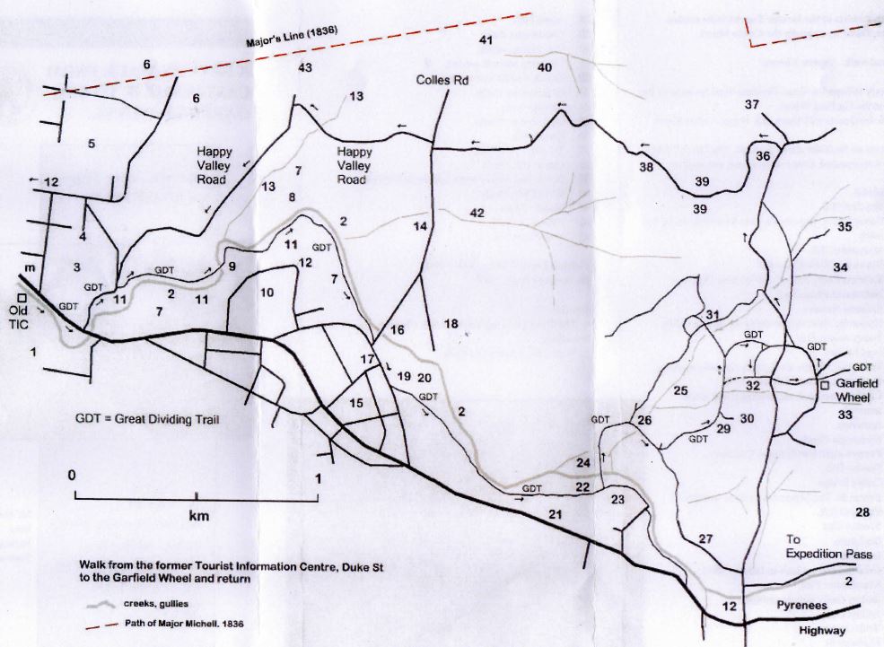
m. Motel
1. Ten-foot Hill.
2. Forest Creek. Expedition Pass Reservoir dams this creek.
3. Monument Hill.
4. Burke and Wills Memorial.
5. Kalimna Point. Part of Castlemaine Diggings National Heritage Park.
6. Kalimna Reserve.
7. Hydraulic sluicing and dredging in this valley.
8. Pennyweight Flat.
9. Foot bridge.
10. Turks Hill. Rocks are Tertiary Gravels, marking the former course of Forest Creek.
11. Castlemaine landcare plantings and weed removal.
12. Anticline.
13. Moonlight Creek.
14. Pennyweight Flat Historic Cemetery.
15. Wesley Hill.
16. Colles Bridge.
17. Farran St. The peppercorn tree is notable.
18. Elephant Hill.
19. Wesley Flat.
20. Sculpture.
21. Iron Hill.
22. Gold discovered here in January 1852.
23. Manchester Flat.
24. Sailors Gully pine plantation.
25. Sailors Gully.
26. Troll Corner
27. Fairbairn St
28. Argus Hill.
29. Manchester Reef.
30. Old mining works.
31. Chimney and old garden.
32. Cyanide tanks and tailings.
33. Little Sailors Gully.
34. German Gully.
35. Englishmans Gully.
36. Quartz Hill.
37. Track to Colles Rd.
38. Quartz Hill Track.
39. Water race tunnel under Quartz Hill Track.
40. Dirty Dicks Gully.
41. Happy Valley.
42. Cemetery Gully.
43. Moonlight Flat.
Location
1 Duke Street, Castlemaine 3450 Map
")


")