Castlemaine - Kalimna Circuit Track

Kalimna Circuit Track is a 1.6 km bush walk in the Castlemaine Diggings National Heritage Park.
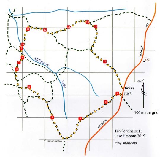
Kalimna Circuit Track Map
To reach the walk
Go to the east end of Lyttleton Street and travel 1.6 km along the Kalimna Tourist Road. The Circuit Track is on the left and is sign posted. The route is sign posted with arrows and numbered markers in a clockwise direction.
On the walk
The walk is along formed tracks, some of which have become eroded. Take care. Wear stout footwear, and clothes suitable for the season.
Heathy Dry Forest
Most of Kalimna Park is a heathy dry forest. Such forests have mixed eucalypts and a shrubby understorey. Grasses and herbs are also common. Kalimna Park is noted for the abundance of plant species, and the wildflower displays in spring. Plants of Kalimna are adapted to periods of extreme dryness. Leaves may reduce water loss by being small, or wiry, or leathery, or hairy or furry. Often a combination of these characteristics can be seen.
Seasonal changes
The Kalimna bushland changes from season to season. In early spring, the wax-flowers and wattles make a spectacular show. In mid-spring, these have been replaced by pink-bells, 'egg and bacon' peas, mint bushes and waxlip orchids. These are followed by chocolate lilies, milkmaids and sun orchids. Later still, grevilleas are in flower, and button daisies, grey ever-lasting and the native grasses are prominent. By December most of these have set seed, and only a few summer flowering plants, such as bursarias are in flower. Over late summer, autumn and early winter there are fewer flowers to be seen. However, the bushland is still full of interest, and some flowers can be found in all seasons.
Long term changes
During the millennium drought many of the shrubs died, and the bushland became much more open. During wetter years, (2010-2011) there was successful regeneration, and the shrub layer has been replaced.
THE WALK
POST 1: Eucalypts Here the common eucalypts are Red Box (with finely fibrous bark on the trunks and branches, and broad, almost oval leaves), Long-leaved Box (also with finely fibrous bark on the trunks and branches, and strap-shaped leaves on the adult trees) and Red Stringybark (the bark has long fibres).
POST 2: Rock strata The layers of rock were laid down under the sea about 450 million years ago. Since then earth movements have tilted the rock so that it is now almost vertical. The pressure came from the east, and in the Castlemaine district the strata are pointing in a north-south direction. This is handy in finding directions when walking through the bush.
POST 3: Coppiced Grey Box Many of the eucalypts are multi-stemmed. Old photographs show that the eucalypts in Kalimna were cut out during the mining years. The trees now present have grown as suckers from the stumps. Some idea of the size of the original trees can be obtained from the space between the suckers.
POST 4: Grasses Most of the indigenous grasses found in Kalimna Park are tussock-forming. This means each plant grows in a single clump, rather than spreading out horizontally like many lawn grasses do. In some places grasses are a dominant feature of the understory, which gives the bush a different character. Here the grasses are mostly Red-anther Wallaby-grass Rytidosperma pallidum, with smaller tussocks of Grey Poa Poa sieberiana interspersed. Native spear grasses Austrostipa spp. are also common in the park.
POST 5: Excavations There are three kinds of excavation in the reserve. Some result from the time Kalimna was a military training area in the 1940s, some from gold mining, and some from quarrying for paving and building stone.
POST 6: Cherry Ballart Cherry Ballart (or Native Cherry) is a cypress-like plant with light green foliage. The seed has a fleshy leaf stalk which turns red, so that the fruit resembles a small cherry with the seed on the end. Cherry Ballarts are root parasites. The roots join to roots of other plants and extract nutrients from them. Although cypress-like in appearance, they are unrelated to the conifers.
The Cherry Ballart (Balatj) has many uses for Djaara (people of the Dja Dja Wurrung). Balatj fruits during the winter-spring months and the fruit is ripe when it is orange-red in appearance and can be eaten at this stage. The leaves are used in smoking ceremonies to cleanse and ward off bad spirits. The wood is strong and made into spears, spear-throwers, and boomerangs. The sap from Balatj is applied to snake bites for its antiseptic properties and to keep bacteria from entering the wound.
POST 7: Bursaria and Hakea The spiky leaves of Bushy Needlewood Hakea decurrens, its spidery white flowers and nuggety seed pods, mark out this characterful plant. Also abundant here is Sweet Bursaria Bursaria spinosa, a prickly shrub with modest white flowers in summer and bronze coloured seed pods. It plays host to the nationally endangered Eltham Copper Butterfly.
POST 8: Grey Box The track is descending to a tributary of Milkman's Gully. The soil is deeper here, and Grey Box is the most common eucalypt.
POST 9: Gold mining The soil is deeper here than on the hillsides, and the shrubs are usually taller and denser. In many parts, the soil has been dug over by miners searching for gold.
POST 10: Tributary of Milkman's Gully The track crosses a shallow gully. Further down stream the gully is more eroded. Rushes are able to grow in the moister conditions along the gully floor. The rushes here are Remote-flowered Rush, so named because of the scattered flowers. In many rushes the flowers are tightly clustered.
Smooth-barked Yellow Gums are growing along sections of the gully. Some of this area has a very sparse shrub cover. A sparse understory is typical of Yellow Gum forests. Variation in the shrub layer is also a feature of local forests.
POST 11: The Devonshire Mine The area on the left (west) of the track was worked until 1930 and reached a depth of 80m. Recovery of vegetation after soil disturbance can be very slow. Weed species are now abundant.
POST 12: Eroded 4WD track The bushland on the north of the track was burned in a small bushfire in the 1980s. This track was bulldozed at that time. As is typical of tracks up slopes, it has become very eroded. Notice that as the track climbs from Milkman's Gully, the Grey Box is replaced by Red Box, Long-leaved Box and Red Stringybark.
POST 13: Headward erosion The track crosses a narrow gully. On the left of the path, erosion has cut a deeper channel. The upper soil surface resists erosion. During heavy rain, the lower softer soil is eroded, to undercut the top layer, in a process called headward erosion. The erosion probably started from disturbance during mining activities.
POST 14: Fuel reduction burning The bushland on the left (north) was burned as part of a fuel reduction burn in spring 2010. The burn was a patchy burn. The blackened bark of tree trunks is the most obvious sign of burning. The height of the scorch marks gives an idea of the burn intensity. Fallen trees are a common feature in a burn area. Shortly after a burn, the extent of scorching and killing of leaves in the canopy are evidence of burn intensity.
Fuel reduction burns
A group of local naturalists has been monitoring the effects of burns in Kalimna and elsewhere in the district. This is done by setting up 20m x 20m sample areas (called quadrats), and by making a list of the plants in the quadrats, and for some plants (usually perennial shrubs and trees) counting the actual number of individual plants. Juveniles (i.e. not yet flowering), mature and senescent plants are counted separately. After a burn, the quadrats are checked to see which parts of the quadrats have been burned, and a map is made showing the burned and unburned areas. Both burned and unburned sites are resurveyed from time to time to see what changes have taken place.
Some of the general conclusions so far are:
- Plant distribution is variable. Sites that are close together often have a quite different plant composition.
- Regeneration occurs in spring in unburned and burned sites
- Some species (particularly legumes e.g. 'egg and bacon' peas) may regenerate profusely after a burn.
- There is much mortality of seedlings during summer and autumn.
- In a drought year, there may be close to 100% death of seedling shrubs and trees.
- In a drought year, seedling success is greater in unburned areas than in burned areas. This may be due in part to greater temperature extremes in the burned areas, and/or the lack of other vegetation to shelter the seedlings and protect them from predators.
- Erosion is much more common in burned areas.
- Multi-trunked trees with dry stumps are often burned out, and fall.
- Burning often removes wildlife habitat, such as old decaying logs and stumps.
- In the 2010 Kalimna burn area, it is now not obvious which of the shrubs are growing in burned areas, and which are from unburned areas unless detailed records have been kept. The burn was followed by a year with moderate rainfall, and so many seedlings have survived.
POST 16: Variable shrub layer The variable distribution of shrubs is particularly evident along this section of the walk, especially in spring. Some plants growing here are rare or absent in other parts of the reserve reserve.
The walk concludes at the Kalimna Tourist Road, a few metres from the start of the Circuit Track.
Location
Kalimna Tourist Road, Castlemaine 3450 Map
Web Links
→ www.kalimnapark.org.au
→ Friends of Kalimna Park on Facebook
")


")