Castlefield Walk (Hampton)

Starting at the Hampton Community Centre, the Castlefield Walk is 4 kilometres long with a walking time of 1 hour. The trail path is moderate in terms of difficulty.
Walk Summary:
Time: 1 hour
Distance: 4 kilometres
Difficulty: moderate
Seats: Alexander Park, Castlefield Reserve, South Road
Melway: ref 76 F5
Bus routes: 600, 708, 811-2, 827-8, 922
Train station: Hampton
Wheelchair access: Sealed footpath entire walk, except in Castlefield Reserve
Parking: Hampton Community Centre, 14 Willis Street Hampton
Toilets: Castlefield Reserve and Willis St
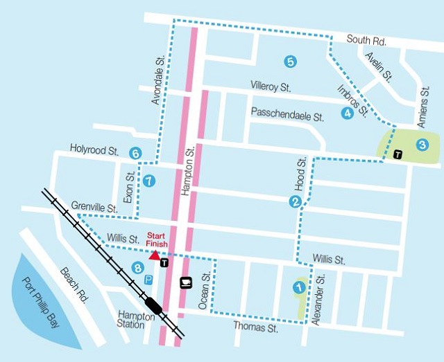
Trail directions:
The walk begins at the Hampton Community Centre. Head east over Hampton Street, turn right into Ocean Street, then left into Thomas Street.
1 To your left you'll discover beautiful Alexander Park. This park was the original site of Ralph's Dairy which once supplied the entire region with milk and ice.
2 From Alexander Street turn into Hood Street, named after a British battle cruiser which was sunk by the Germans in 1941.
3 A highlight of this walk is Castlefield Reserve, which was named after the old Castlefield Estate that once comprised all of this area. Follow the path on the left through to Imbros Street.
4 Imbros Street was named after the Aegean Sea Island where Australian soldiers were based before being sent to Gallipoli in WW1. Continuing with the military theme, several nearby streets are also named after WW1 battlefields. In fact the estate around the reserve was developed by the "War Service Homes Commission" in 1924 to house ex-servicemen. Many of these homes still remain.
5 As you walk along South Road, take a glance across the playing fields of Haileybury College where you'll find the original Castlefield residence located in the middle of the school grounds. This residence was originally built in 1852 and has been extended many times.
6 As you pass through Holyrood Street, you'll notice on your right the beautiful St Mary's Catholic Church which was built in 1925.
7 Turn left into Exon Street. As you walk this street, you'll notice that it's not quite straight. Amazingly, it was diverted around two existing houses!
8 Turn left into Willis Street and follow the red brick path back to the Hampton Community Centre. Now that you've completed your walk and enjoyed the sights of Hampton, take the time to enjoy the variety of shops and eating establishments available in Hampton Street.
Map:
It is highly recommended to follow the walks using the Bayside Walks & Trails app which is available on iTunes or Google Play.
Location
14 Willis Street, Hampton 3188 Map
Web Links
→ Castlefield Walk trail map (PDF)
")


")