Camping around Mansfield

The town of Mansfield is nestled in the foot hills of the Victorian High Country. Surrounded by hills and mountains, rivers and streams, it has much to offer those interested in fishing, exploring, bushwalking and camping. Spend some time enjoying the tranquillity in one of the lovely camping areas located within about half an hours drive from Mansfield.
The closest camping sites are little more than 30 minutes from Mansfield - others are far from civilisation! Stunning camping sites dot the landscape around Mansfield Mt Buller. Nestled next to a high country river or perched high up in the hills, these sites are the perfect place to base hiking, fishing, four-wheel driving or mountain-biking adventures.
Grab a book and relax on a camping chair while the kids roam in the great outdoors. At the end of the day, gather the family for a feed and tales around the camp fire. Simple living at its best.
Many camp sites are accessible with two-wheel drive vehicles, however others require four-wheel drive access.
Please Note: Many tracks in the High Country are closed during the winter seasonal road closures between June and early November. These closures generally operate from the long weekend in June through to the beginning of November, but may be extended due to seasonal conditions. Contact the Mansfield Visitor Information Centre for more details.
Camping Sites
Blue Range Camping and Picnic Area (Blue Range Road, Bridge Creek)
Blue Range offers a small, basic camp site on Blue Range Creek, 20 minutes north of Mansfield via Mansfield - Whitfield Road. The campsite is on the edge of the Mt Samaria State Park, in a quiet location near a small creek and in natural bushland. Toilet facilities are across the road in the picnic area.
Bluff Hut (Bluff Track, Mount Buller)
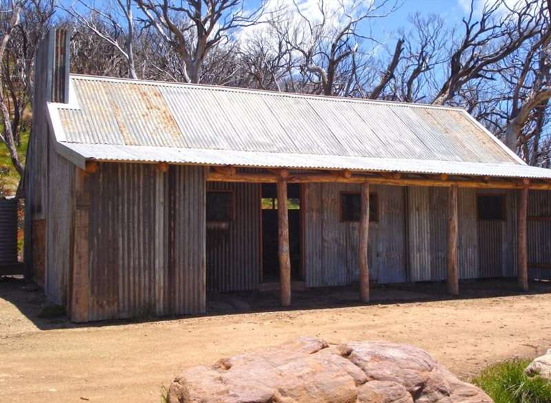
Located in the Alpine National Park, Bluff Hut is the third highest hut in Australia. The original hut, built in the 1950's, was burnt down in the 2007 fires and has since been rebuilt.
Bluff Hut offers basic camping for car-based campers and hikers. From the hut it is a short walk to the Bluff, which offers uninterrupted views of the surrounding mountains.
Please note access by vehicle is not possible from June to November due to seasonal track closures in the High Country.
Buttercup Creek Camping Area (Buttercup Road, Merrijig)
The tumbling water in Buttercup Creek provides a peaceful background sound within these small, shady sites. It offers good access for bushwalking, horse riding, mountain bike riding and four wheel driving. Two wheel drive access is via Carter's Road off the Mt Buller Road. Four Wheel drives can use Buttercup Road to access the campsites, involving two creek crossings.
Carters Mill Camping and Picnic Area (Plain Creek Loop Walk, Mirimbah)
Carter's Mill Picnic and Camping Area is less than 30 minutes from Mansfield on the way to Mount Buller. The camping area is a small, sheltered site, close to the Delatite River and the walking tracks along Plain Creek. This campsite is a great base for 4WD day trips into the surrounding high country. Popular walks include Plain Creek Loop Walk, Tramway Bridge Walk, Plain Creek Waterfall and Tomahawk Hut.
Carter and Co. built a sawmill at this site in 1937 to mill the timber from the surrounding forest. In the early days timber was brought down to the mill from the forest by a single line five horse team along timber tramways. After the 1950s these were replaced by motor vehicles on bush tracks. Carter's Mill was destroyed by fire in January 1965.
Granny's Flat Camping Area (Jamieson-Licola Road, Jamieson)
The very popular Granny's Flat is located on the Jamieson River. Access is 4WD in wet weather. Mitchell's Bridle Trail, 21km walking track starts from here and follows the Jamieson River to Mitchell's Flat.
Granny's Flat Camping Reserve is closed during the seasonal road closure period that is in place from the Thursday after the Queens Birthday Long Weekend in June until the Thursday before Melbourne Cup Weekend in November.
Howqua Hills Historic Area (Howqua Track, Howqua Hills)
Howqua Hills Historic Area is a site of natural beauty. Set in a secluded valley on the Howqua River it was once busy with gold miners. River flats are surrounded by hills with Manna Gums and Narrow‐Leaved Peppermints. Howqua Hills Historic Area is approximately one-hour drive from Mansfield and is a popular spot for picnics, horse riding, bushwalking, fishing and four-wheel driving. Start your visit to the park at the information shelter at Sheepyard Flat North, which gives fascinating information about the area.
Camping along the Howqua River is one of the best ways to enjoy this historic area and out door adventure activities. There are several flats available beside the river, including popular Fry's Flat, Sheepyard Flat and Davons Flat. No booking is required. Camping is on a first in, first‐served basis.
Enjoy the Howqua Hills Historic Walk an easy four kilometre return walk following the Howqua River from Sheepyard Flat to Fry's Flat. Other walks in the area include the High and Low Tracks along the Howqua, Lickhole Creek, Eagles Peaks and the Bluff walk. For more information see the Howqua Hills Historic Area Visitor Guide.
King Hut Camping Area (King Basin Road, Mount Stirling, Mount Buller)
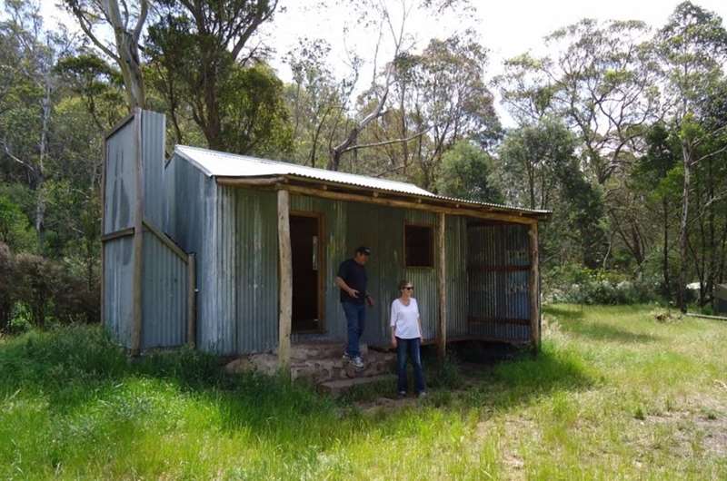
King Hut is located on the western edge of the Alpine National Park, about 15 kilometres north-east of Mt Stirling, alongside the King River. The 4WD access route heads down Speculation Road, which is reached via a turn-off from Circuit Rd about 6 km south-east of the Craig's Hut turn-off. There are horse yards here for use by intrepid explorers. The hut itself is in excellent condition, having been recently rebuilt.
Note that access by vehicle is not possible from June to November due to seasonal track closures in the High Country.
Pickering's Flat Camping Area (Brocks Rd, Howqua Hills)
Free campsite near the Howqua River with toilets.
Ritchie's Hut (Brocks Road, Via 8 Mile Flat, Howqua Hills)
Nestled amongst the mountains and on the banks of the Howqua River, Ritchie's Hut is located in the Alpine National Park and can only be accessed by walking trail.
Follow either the High Track or Low Track along the Howqua River from Eight Mile Flat to Ritchie's Hut. The low track involves multiple river crossings to travers along the track. Delightful mountain river scenery and fishing with free camping areas riverside. Eight Mile Flat subject to seasonal closures June - November, however walk can be commenced at Seven Mile Flat during seasonal road closures. No mobile service in this area.
Running Creek Camping Reserve (Steiners Road, Howqua)
Set in State Forest on the Howqua River, just 40 minutes from Mansfield, Running Creek is popular with anglers, paddlers and campers. Located on the Howqua River and accessed via Howqua River Road. After approximately 10 kilometres on gravel road you will reach the reserve. There are two walking tracks that start here and end at Tobacco Flat, approximately 12 km upstream. The Howqua River Walk follows the river flats with nearly 40 river crossings, while the Lower Howqua Feeder traverses the higher country.
Sheepyard Flat (Howqua Track, Merrijig)
Sheepyard Flat is in the Howqua Hills Historic Area near Mansfield, Victoria. It offers free camping next to Howqua River and is a great base for hiking, fishing and 4WD adventures into the Victorian High Country.
Walkers can enjoy the Howqua Hills Historic Walk with self guided interpretive panels. This easy 1.5 hour return track follows the Howqua River from Sheepyard Flat to Fry's Flat.
Facilities include drop toilets, fireplaces and picnic tables. To get to Sheepyard Flat, drive to Merrijg and turnoff onto Howqua Track. From there it is a 17km drive along a winding dirt road.
Stringybark Creek Camping Area (Tatong-Tolmie Road, Tatong)
A free camping area located in the Toombullup State Forest near Tolmie, northeast of Mansfield.
This site links by a walking track to the Stringybark Creek Day Reserve, site of the infamous shooting of three policemen by the Kelly Gang in 1878, and part of the Ned Kelly Touring Route.
Large expansive sites in a natural bushland setting. Pit toilets, fireplaces and picnic tables available. This bush site operates on a first in first served basis and is not bookable.
The Delatite Arm Reserve (Walshs Road, Howes Creek)
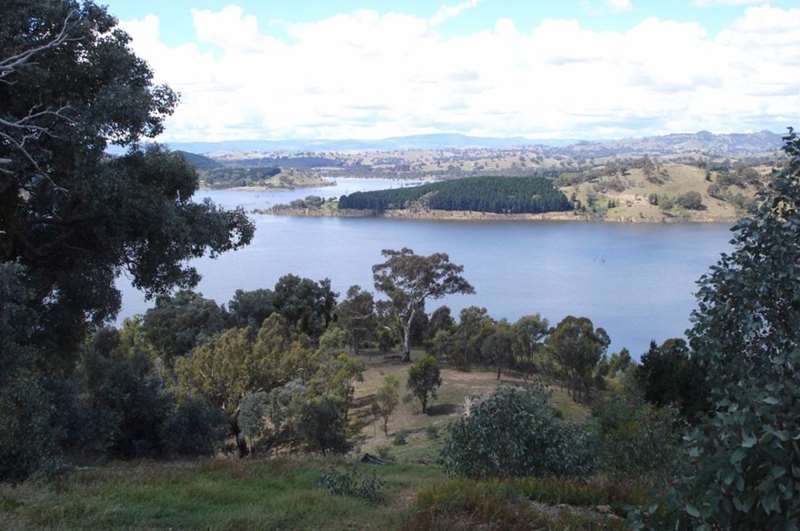
The Delatite Arm Reserve, also known as 'The Pines' is located on the shores of the picturesque Lake Eildon near Goughs Bay.
Numerous free bush campsites are located along the lake and most of the campsites have access to toilets. This State Forest reserve is popular for camping, water sports, scenic views and fishing. A network of forest tracks provide opportunities for four wheel driving, trailbiking, mountain biking and bushwalking.
Location of Camping Places around Mansfield

Safety
On Code Red Fire Danger Rating days, parks and State Forest are closed to the public. Do not enter parks or forests on Code Red Days. If you are already there when a Code Red day is declared, you should leave the night before or early in the morning.
Access for Dogs:
These sites permit dogs on leash unless specified otherwise.
Web Links
→ Camping around Mansfield Guide (PDF)
→ Howqua Hills Historic Area Visitor Guide (PDF)
")


")