Buninyong - Mount Buninyong Circuit Trail

The summit of Mt Buninyong is 1054m above sea level and is the spot where Europeans first saw the Ballarat district in 1837. There are picnic facilities and spectacular views from the tower which take in the Grampians and even the ocean on a clear day.
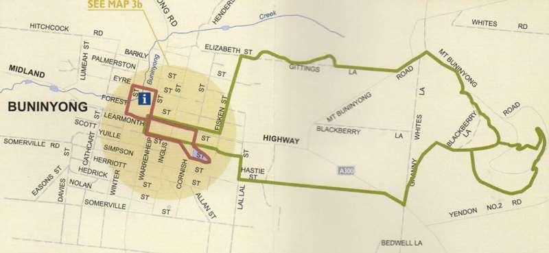
For the 5.3km Mount Buninyong Circuit Trail, follow the Union Jack walk from De Soza Park via the Buninyong Creek and Elizabeth St. Spend some time exploring the Union Jack Reserve and then continue up Gitting's Lane. Turn left on Mt Buninyong Road and then, after about 150m, turn right in to Granny White's Lane for approximately 600m.
Turn left up the track marked "Court House to Mt. Buninyong walk". Continue up this track for about 1km which becomes a gravel road. Turn right on the track towards the crater. Walkers can choose to loop around the mount in either direction though the South Walk is easier to find from this direction. It diverges to the right from the crater track.
After visiting the mount, retrace your steps to Granny White's Lane. Turn left and follow the "Court house to Mt Buninyong" walk markers. Cross the Midland Highway at Hastie's Lane and follow the lane down to a left at Lal Lal St. Take a short right on Simpson St. Turn right at Fisken St into the Gong Reserve and then through the Botanic Gardens. A right turn on Inglis St, will take you back to the centre of Buninyong.
Start at De Soza Park, 502 Warrenheip Street, Buninyong.
Map of Mount Buninyong Circuit Trail Route
Location
502 Warrenheip Street, Buninyong 3357 Map
")


")