Beaufort - Camp Hill Walk

Take a lovely 2.9km stroll on this great easy track around Camp Hill. Start at the lovely picnic area and proceed around the track to a picturesque views of Beaufort from above.
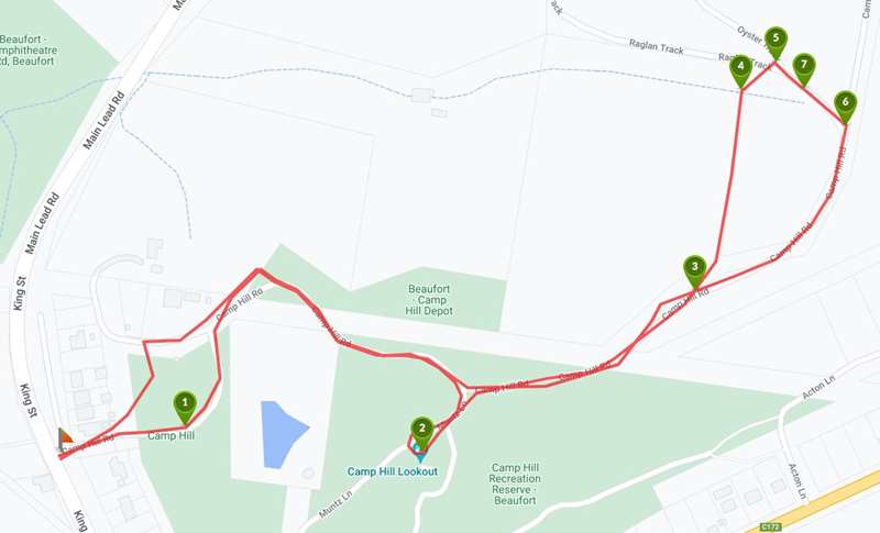
Take a drive up King Street toward Raglan and start the walk at the base of Camp Hill Road. Continue so the BBQ and picnic area is on your left. As you head up the track you will come to a fork in the road that heads to the look out point. Take a quick tour of the look out and snap a photo. Now back out to the Camp Hill Road and head north east on the track until you come to the junction of Oyster Track Rd. At the Oyster Track road sign verve left. Stay on the track continuing to a fork in the road, this time taking the right prong. From this point forward continue veering right until you connect again with Camp Hill Road which will take you back to the top of the picnic area. This is a great wide track that is suitable for horses and kids on bikes.
Map of Route
Interactive Map
Points of Interest
1. BBQ and Picnic Area
Start and end point of the walk.
2. Look Out
View Beaufort from above
3. Oyster Track Junction
Take Oyster Track
4. Fork in the road
Take the left track
5. Fork in the road
Take the left track
6. Connect with Camp Hill Road
Turn right onto Camp Hill Road and continue to the BBQ and Picnic Area
7. Furry Friends
If you are quiet, you might come across some of the local wildlife.
Location
24 King Street, Beaufort 3373 Map
Web Links
→ Camp Hill - Oyster Track Loop (Walking Maps)
")


")