Bay Trail (Seaford - Port Melbourne)

The full Bay Trail runs from Seaford to Port Melbourne over a distance of 48.5km.
A route description is:
Seaford - Mordialloc section
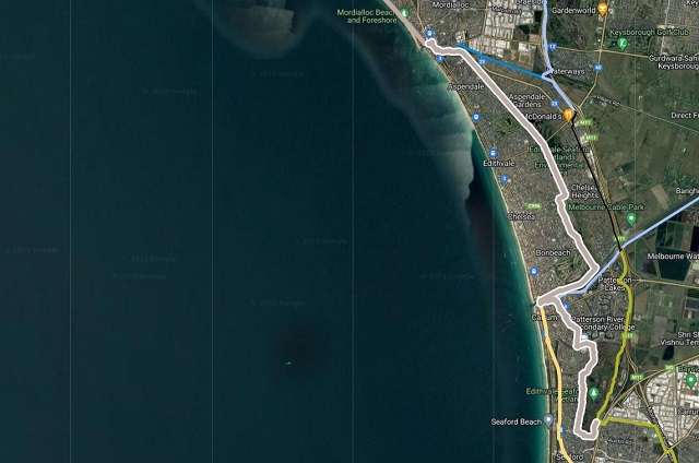
- In the south, the trail begins a short distance from Seaford railway station on the corner of Austin Road and Erwin Drive.
- Following the path, head north on the west side of the Seaford Wetlands.
- The trail appears to end at Armstrongs Road in Seaford, however it continues at the end of Wilson Grove; the first street to the right.
- At Seaford North Primary School, take the right path through the woodlands.
- The path runs parallel to the Eel Race Drain next to Patterson River Secondary College. Take the footbridge over the Eel Race Drain.
- Once across the footbridge, turn right along the gravel path that runs next to Emma Street. The path goes inbetween the backs of the houses.
- Take the left path to travel through Roy Dore Reserve in Carrum. You may have to ride along Dyson Road past the kindergarten because there is no path. When the street turns to go left, turn right along the path that heads north through the houses towards the Patterson River.
- A set of pedestrian lights has been installed on busy McLeod Road, Carrum, opposite McDougall Reserve. On the northern side of the crossing is Launching Way, where the trail continues towards the Patterson River boat launching ramps. Turn left onto the Danadenong Creek Trail/Bay Trail; where the trail then heads south-west for a short distance (0.5 km) towards the bay.
- Just before the Nepean Highway/Frankston Train Line overpass, ride up to the new Station Street bridge and cross the Patterson River, heading back down onto the northern embankment. Head north-east inland for approximately 2 km along the Patterson River track.
- After 2 km, merge left down an embankment onto the Long Beach/Bay Trail now heading north-west towards Mordialloc.
- Travel through Bicentennial Park, past the netball Courts and to the set of traffic lights on Thames Promenade. Cross Thames Promenade and continue down the track.
- Cross Edithvale Road at the lights and head past the Edithvale Recreation Reserve, still heading north.
- Stay on the gravel path, going past Browns Reserve and Mordialloc College.
- The trail then goes under the railway bridge at Mordialloc. Ride through the carpark, then merge onto the Nepean Highway footpath.
- Straight after crossing the Mordialloc Creek, take a sharp right and travel through the underpass at Nepean Highway. Follow the trail towards the Pier, taking the right path before the Tour De Cafe.
Mordialloc - Port Melbourne section
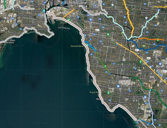
- Follow the path to the beach, and from Mordialloc onward, the trail now runs along the coast between the sand and Beach Road. Take the concrete path along the foreshore through the Mordialloc Beach, and then take the gravel section of the trail between Mordialloc and Parkdale, running between the sand dunes.
- At the Parkdale Beach Cafe and Kiosk, the Bay Trail is still yet to be extended to the Mentone Life Saving Club. Walkers can take the concrete path down to the shore and follow that to the Mentone Life Saving Club, but cyclists should probably use Beach Road after the Parkdale Yacht Club.
- From Mentone Life Saving Club onward, the trail is concrete, with a dashed line in the centre.
- From here, navigation is fairly self-explanatory. The trail heads north-west towards Port Melbourne, passing through the suburbs of Black Rock, Sandringham, Hampton, Brighton, Elwood, St Kilda, Middle Park, and Albert Park.
- The trail ends at Sandridge Life Saving Club, near the mouth of the Yarra River
")


")