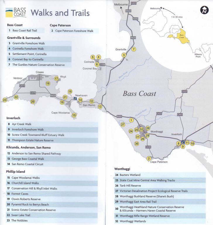
Bass Coast Best Walks and Trails

Bass Coast has a wonderful range of rail trails, bushland and coastal walks offering diverse environments to explore. Key walks and trails include the spectacular George Bass Coastal Walk and the Bass Coast Rail Trail which is Victoria's only coastal rail trail and showcases the region's rich history against stunning coastal views.
Phillip Island's walks and cycle tracks are stunning with Rhyll Inlet being listed under the Ramsar Convention for sites containing representative, rare or unique wetlands and more than a quarter of Phillip Island is conserved for the environment.
Each walk contains a summary of length and approximate time (based on the time it takes to walk, not cycle, calculated at an average pace of 4km per hour), difficulty, track surface, suitability for bikes and prams, location, parking, toilets, access for dogs and access for horses.
If you see sick or injured wildlife on your walk, call Wildlife Rescue on 1300 094 535.
Bass Coast
1. Bass Coast Rail Trail
Victoria's only coastal rail trail showcases the region's rich history against stunning coastal views. The trail runs through Wonthaggi and farmland and leads to the coast, passing historical sites along the way to Woolamai.
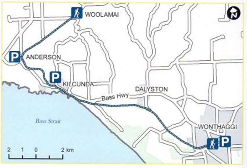
Length/Time: One way - 23km / 6 hours
Difficulty: Easy, mostly flat with two moderate climbs (uphill from Wonthaggi)
Surface: Compacted granitic sand, gravel, boardwalk. Suitable for bikes and prams.
Location: Bent Street, Wonthaggi; Bass Highway, Kilcunda; Anderson or Woolamai
Parking: Car parks (sealed) at Wonthaggi Centennial Centre, Anderson Bus Interchange, Kilcunda foreshore
Toilets: Wonthaggi Centennial Centre, Wonthaggi Guide Park, Kilcunda Foreshore Reserve, Anderson Bus Interchange
Mobility Access: Suitable, sections closest to Wonthaggi and Kilcunda being the most accessible
BBQ: Wonthaggi Guide Park and Kilcunda
Horses: Yes, West of South Dudley Road
Dogs: Dogs allowed on lead
Cape Paterson
2. Cape Paterson Foreshore Walk
Foreshore track through bushland to a number of lookouts along clifftops. Views of coastline with access to beach and rock pools. Look for swimming pool near boat ramp, blasted from rock platform by miners in 1910.
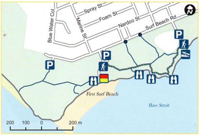
Length/Time: Return - 1.4km / 20 minutes
Difficulty: Easy, gentle undulations
Surface: Compacted gravel, boardwalk, soft sand. Suitable for prams
Location: Surf Beach Road, Cape Paterson
Parking: Three car parks (all sealed) off Surf Beach Road, Cape Paterson
Toilets: Wonthaggi Surf Life Saving Club, First Surf Beach car park
Mobility Access: Suitable for 1km from Surf Beach Road to main track and between boat ramp and First Surf Beach car park
Dogs: Dogs permitted on a lead (but not down onto the beaches 9am-6pm December to April)
Grantville & Surrounds
3. Grantville Foreshore Walk
Short walk along Grantville Foreshore with views of Western Port, French Island and Western Port's mangrove habitats. Keep a look out for some of the 300 bird species that make Western Port their home.
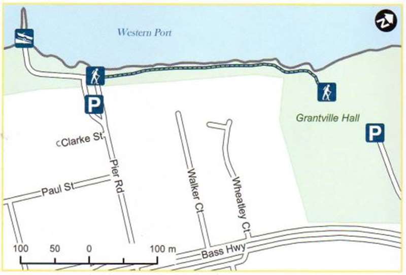
Length/Time: Return - 720m / 10 minutes
Difficulty: Easy
Surface: Compacted granitic sand and soft sand, Suitable for prams and bikes.
Location: Pier Road, Grantville
Parking: Car park (sealed), Pier Road, Grantville
Toilets: Boat Ramp car park, Pier Road, Grantville & Grantville Memorial Park, Pier Road, Grantville
Dogs: Dogs allowed on lead
4. Corinella Foreshore Walk
Sheltered walk with views of French Island and Western Port, a large tidal bay, home to swans and other waterbirds.
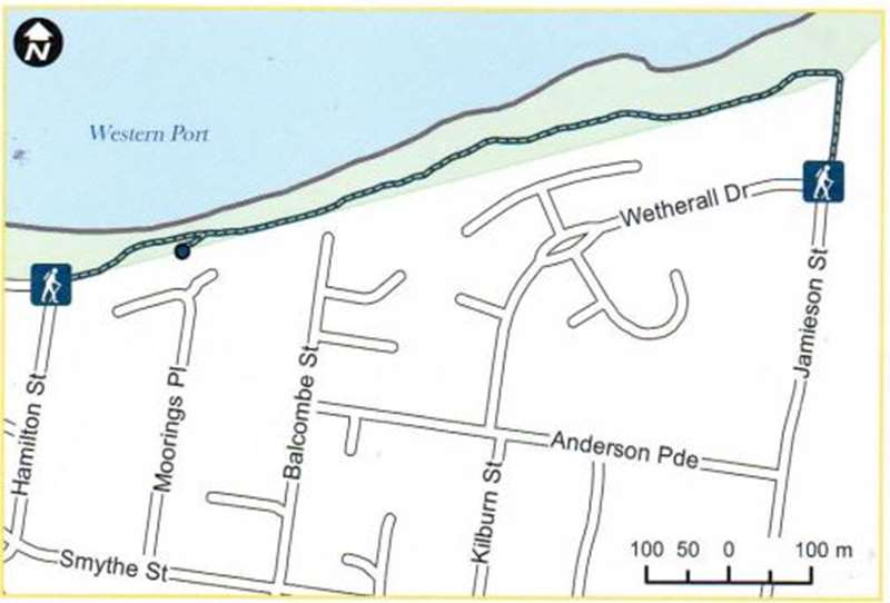
Length/Time: Return - 2.3km / 40 minutes
Difficulty: Easy, gentle undulations
Surface: Compacted gravel, bluestone gravel. Suitable for prams and bikes
Location: Jamieson Street, Corinella
Parking: End of Jamieson Street (grass), Corinella
Dogs: Dogs allowed on lead
5. Settlement Point, Corinella
Walk takes you through native vegetation to lookout with views of French Island, Western Port cliffs, mangroves, seagrasses and melaleucas.
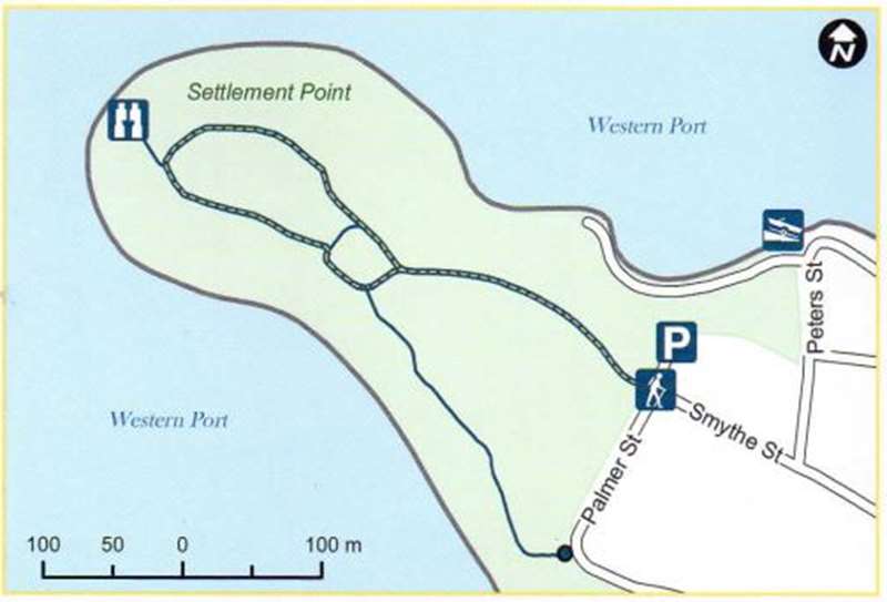
Length/Time: Return - 850m / 15 minutes
Difficulty: Easy
Surface: Compacted granitic sand, soil, grass. Suitable for bikes and prams.
Location: Settlement Point, Smythe Street, Corinella
Parking: Car park (unsealed), Smythe Street, Corinella
Mobility Access: Main track suitable (except in wet weather)
Dogs: Dogs allowed on lead
6. Coronet Bay to Corinella Walk
Coastal walk through She Oaks and Coastal Banksia with views of Western Port cliffs and coastline. Close to the start of the walk, there is a small wetland area, home to many waterbirds.
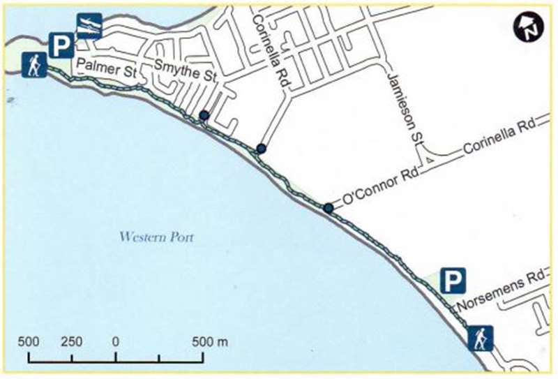
Length/Time: Return - 6.7km / 1 3/4 hours
Difficulty: Easy, uphill section near Settlement Point
Surface: Compacted granitic sand. Suitable for bikes and prams
Location: Norsemens Road, Coronet Bay to Palmer Street, Corinella
Parking: Car parks (unsealed) in Norsemens Road, Coronet Bay and Palmer Street, Settlement Point, Corinella
Dogs: Dogs allowed on lead
7. The Gurdies Nature Conservation Reserve
The Reserve is 260 hectares with multiple walking tracks and represents some of the largest remaining areas of native vegetation on the eastern shore of Western Port. Look out for native orchids. The Gurdies is home to a variety of animals and birdlife.
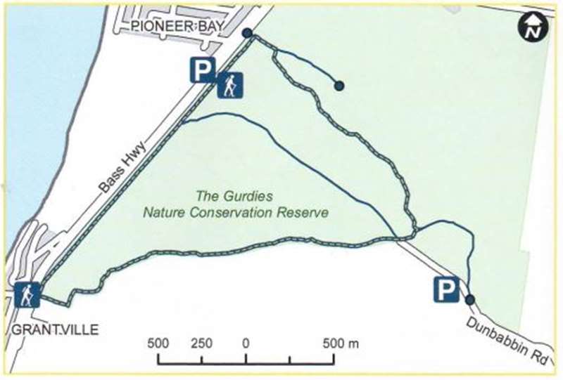
Length/Time: Circuit - 5.8km / 1 1/2 hours
Difficulty: Easy
Surface: Sand, gravel.
Location: Bass Highway or Dunbabbin Road, The Gurdies
Parking: Bass Highway car park (sealed) or Dunbabbin Road car park (unsealed)
Cycling: Mountain bike riding is permitted on vehicle-width tracks
Horses: Horses may use vehicle-width tracks south of and including the central management track
Dogs: Dogs allowed on lead
Inverloch
8. Ayr Creek Walk
Stroll through native bush and wetlands, home to lots of birdlife. Start from Nesci Court, Inverloch to Royal Parade, cross the road, take track through to Toorak Road, and walk down Evergreen Avenue. Pick up track from the corner at Beach Avenue through to Surf Parade and cross the road to the beach.
Length/Time: Return - 3.4km / 1 hour
Difficulty: Easy
Surface: Compacted sand, boardwalk, grass, bitumen. Suitable for bikes and prams
Location: Nesci Court, Inverloch
Parking: Nesci Court car park (sealed) or Ramsey Boulevard street parking (sealed)
Mobility Access: Suitable for 2km (return) from Nesci Court to Royal Parade
Dogs: Dogs allowed on lead
9. Inverloch Foreshore Walk
Shared pathway with access to foreshore between Cuttriss Street and Ayr Creek bridge. Views of Anderson Inlet and Point Smythe from several vantage points. Playground, picnic area and exercise stations located along the walk. An access ramp connects the walk to the beach at Rotary Centennial Park.
Length/Time: Return - 5km / 1 1/2 hours
Difficulty: Easy, reasonably flat, moderate rise near Wyeth McNamara (Rainbow) park
Surface: Concrete. Suitable for bikes and prams
Location: Ramsey Boulevard, Inverloch and The Esplanade, Inverloch
Parking: Car parks (sealed) in Ramsey Boulevard at Rotary Centennial Park and Wyeth McNamara (Rainbow) Park, and on The Esplanade at Inverloch Jetty and next to the Angling Club
Toilets: Bunurong Environment Centre, Ramsey Boulevard, Rotary Centennial Park, Ramsey Boulevard, The Angling Club, The Esplanade near Cuttriss Street
BBQ: Rotary Centennial Park, Rainbow Park
Dogs: Dogs allowed on lead, see signage for season / time restrictions
10. Screw Creek Townsend Bluff Estuary Walk
Scenic trail over boardwalks and saltmarsh over Screw Creek and up to Townsend Bluff which has views over Anderson Inlet. The track splits after the bridge at Screw Creek, the left track continues onto fishing platforms and the right track winds up to the lookout at Townsend Bluff.
Length/Time: Return - 2km / 30 minutes
Difficulty: Easy
Surface: Soft sand, compacted gravel, boardwalks and steps. First part of the walk only for prams due to soft sand before boardwalk.
Location: Foreshore Camping Reserve Road, a continuation of The Esplanade, Inverloch
Parking: Car park (unsealed) at the end of the Foreshore Camping Reserve
Dogs: Dogs allowed on lead
11. Thompson Estate Nature Reserve
This bushland walk includes features of the original woodland and low-lying swamp paperbark thickets, which once covered the land where Inverloch now stands. This is a marked nature walk and the South Gippsland Conservation Society pamphlet corresponds to the pegs along the track to provide information on flora and fauna.
Length/Time: Loop - 2km / 30 minutes
Difficulty: Easy
Surface: Dirt, grass. Parts of the walk are suitable for prams.
Location: Inverloch-Venus Bay Road, Cuttriss Street, or Pier Road, Inverloch
Parking: Car park (unsealed) Inverloch-Venus Bay Road, Inverloch and street parking (sealed) in Pier Road and Cuttriss Street, Inverloch
Dogs: Dogs allowed on lead
Klicunda, Anderson, San Remo
12. Anderson to San Remo Shared Pathway
Shared pathway that runs adjacent to Phillip Island Road with views of Western Port, San Remo and the Phillip Island bridge. The pathway starts at Anderson and finishes at Potters Hill Road, with plans to extend the path into the town of San Remo.
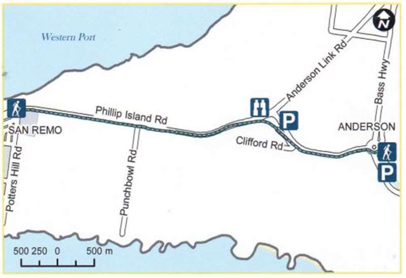
Length/Time: Return - 8km / 2 hours
Difficulty: Moderate to difficult due to steep inclines
Surface: Gravel, concrete, boardwalk. Suitable for bikes.
Location: Phillip Island Road and Bass Highway, Anderson to Potters Hill Road, San Remo
Parking: Anderson Interchange car park (sealed), at roundabout, Phillip Island Road and Bass Highway, Anderson
Toilets: Closest toilets are Anderson roundabout bus interchange
Mobility Access: Difficult due to steep inclines, suitable at Potters Hill Road end to see views
Dogs: Dogs allowed on lead
13. George Bass Coastal Walk
Follow the route of explorer George Bass along this clifftop path which rises high above the pounding surf of Bass Strait and offers panoramic coastal views. The winding path passes through farmland and the Punchbowl Coastal Reserve. Note that beach access is at low tide only.
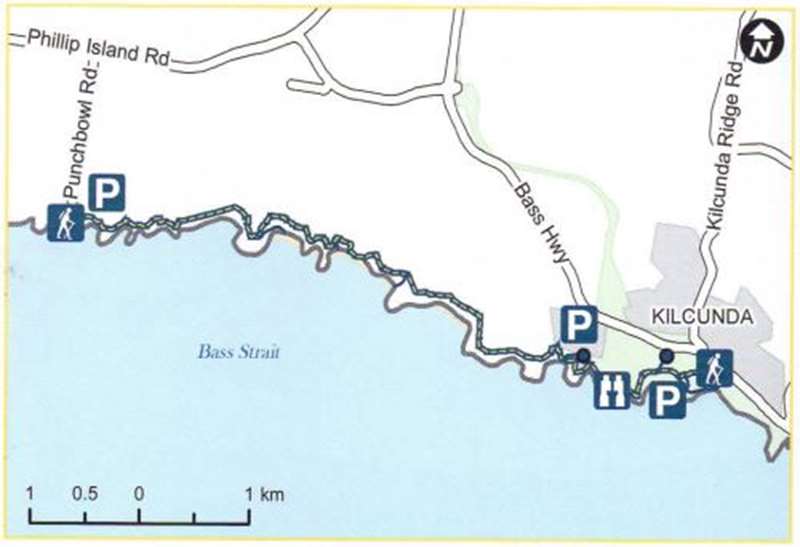
Length/Time: Return -14km / 4-6 hours
Difficulty: Moderate to difficult
Surface: Various, mowed grass, mud, beach sand
Location: Bass Highway, Kilcunda or Punchbowl Road, San Remo
Parking: Car parking in Kilcunda (sealed) and Punchbowl Road (gravel)
Dogs: Dogs allowed on lead
14. San Remo Coastal Circuit
Scenic coastal track with views of Cape Woolamai, the bridge to Phillip Island and Western Port. The track curves around Davis Point and follows the length of Children's Beach and Back Beach. This walk can be completed as a circuit through San Remo or continued along the coast.
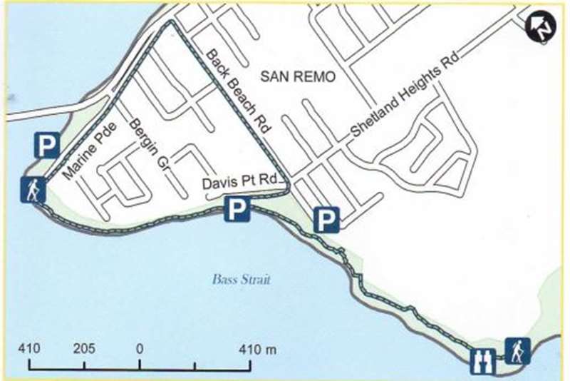
Length/Time: Circuit walk - Loop - 2.5km / 40 minutes, Coastal walk - Return - 4km / 1 hour
Difficulty: Easy
Surface: Gravel, sand, stone, beach, stairs and concrete path. Unsuitable for bikes and prams except for Marine Parade and Back Beach Road
Location: Marine Parade, Davis Point Road or Back Beach Road, San Remo
Parking: San Remo Foreshore car park (sealed) Car parks in Marine Parade (sealed); Davis Point Road (sealed); and Lions Park, Back Beach Road (unsealed)
Toilets: San Remo Foreshore car park and Lions Park, Back Beach Road, San Remo
Dogs: Dogs allowed on lead, see signage for season / time restrictions
Phillip Island
15. Cape Woolamai Walks
Cape Woolamai, the highest point on Phillip Island, has spectacular views and is home for up to a million shearwaters between October and April each year. From car park, walk onto beach, turn left, follow beach for approximately 1km, take stairs up to clifftop to loop walks.
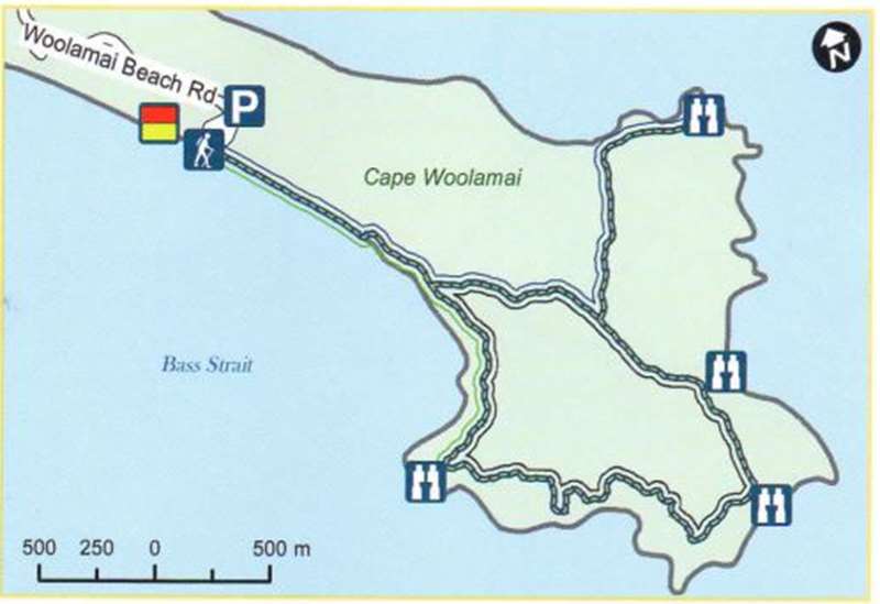
Length/Time: Pinnacles Walk (green markers) Return - 4.5km / 1 1/2 hours, Old Granite Quarry Walk (blue markers) Return - 6km / 2 hours, Cape Woolamai Beacon Walk (black markers) Return - 6.6km / 21/2 hours, Cape Woolamai Circuit - (all three walks combined) Return - 8km / 4 hours
Difficulty: Moderate
Surface: Sand, exposed tree roots, uneven ground, cliff edges, and can be muddy
Location: Woolamai Beach Road, Cape Woolamai, Phillip Island
Parking: Woolamai Beach car park (sealed)
Toilets: Woolamai Beach car park
Dogs: Dogs not permitted
16. Churchill Island Walks
Churchill Island is a small island with historic buildings, gardens and walking tracks. Access to the walking tracks and the cafe is free, however there is an admission fee to the historic homestead and gardens on the island.
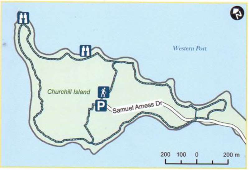
Length/Time: Island Loop - 5km / 1 1/2 hours, North Point Loop - 2.5km / 45 minutes
Difficulty: Moderate
Surface: Compacted granitic sand. Suitable for bikes and prams
Location: 246 Samuel Amess Drive, Churchill Island (via bridge from Phillip Island near Newhaven)
Parking: Churchill Island Visitor Centre car park (sealed)
Toilets: Churchill Island Visitor Centre
Dogs: Dogs not permitted
17. Conservation Hill and Rhyll Inlet Walks
Rhyll Inlet is a world renowned habitat for migratory waders and resident birds. The mangroves and wetlands are listed under the Ramsar Convention as having international importance. Information signs are provided along the walks.
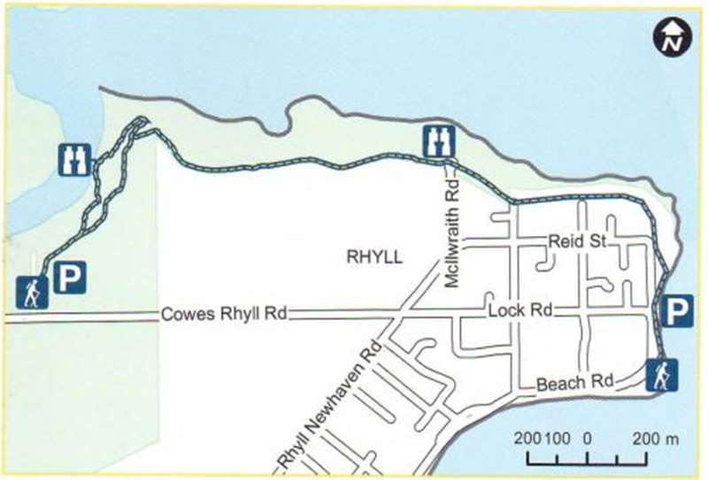
Length/Time: Mangrove Boardwalk - Return - 1.2km / 25 minutes, Mcllwraith Road Lookout - Return - 4.5km / 1 hour, Rhyll Village - Return - 7km / 21/2 hours
Difficulty: Easy to Moderate
Surface: Compacted granitic sand, boardwalk, grass. Suitable for bikes and prams
Location: Cowes-Rhyll Road, Phillip Island
Parking: Car parks in Cowes-Rhyll Road (unsealed) and Beach Road, Rhyll (sealed)
Toilets: Conservation Hill car park
Mobility Access: Mangrove Boardwalk suitable
BBQ:
Horses:
Dogs: Dogs allowed on lead, see signage for season / time restrictions
18. Forrest Caves
Forrest Caves are sea caves formed by erosion of the cliffs over many years. The caves are only accessible at low tide. The walk passes by large sand dunes, home to thousands of short-tailed shearwaters from October to April. Walk up the steps from the car park on to the beach and then turn left.
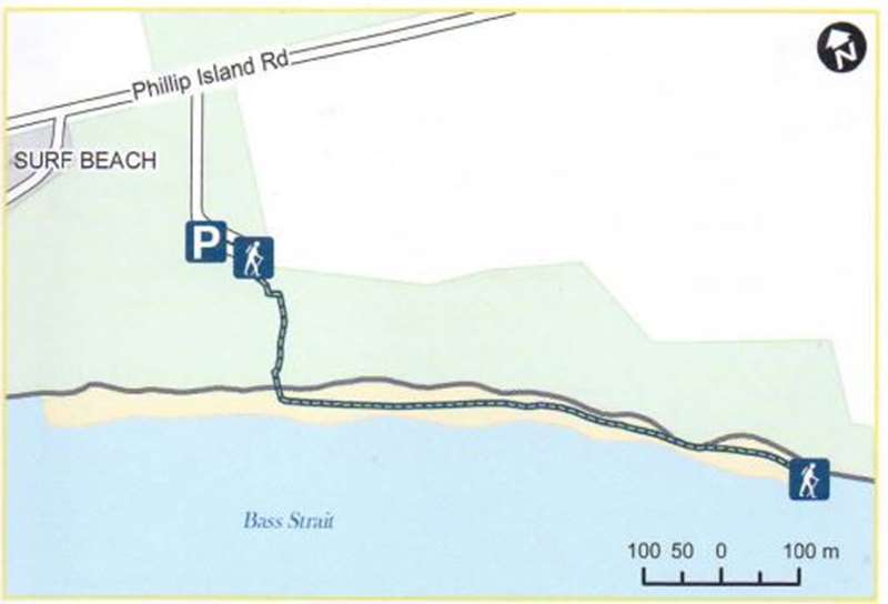
Length/Time: Return - 2km / 45 minutes
Difficulty: Easy
Surface: Beach sand, steps
Location: Phillip Island Road, Phillip Island (200m past Boobialla Road from Newhaven)
Parking: Car park (gravel)
Toilets: Forrest Caves car park
Dogs: Dogs not permitted
19. Oswin Roberts Reserve
Oswin Roberts Reserve is the last area of remnant bushland on Phillip Island. The walking tracks allow for wildlife observation.
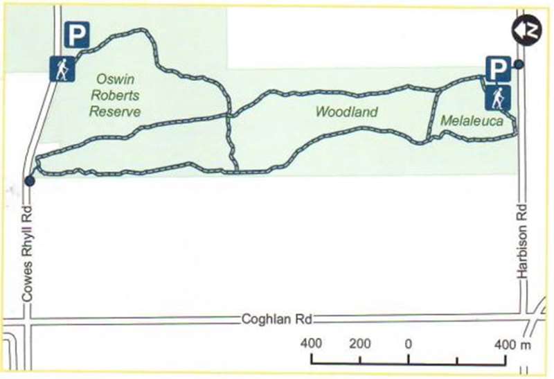
Length/Time: Oswin Roberts Circuit - 4.6km /1 1/4 hours, Woodland Loop - 2.8km / 45 minutes Melaleuca Loop - 1km / 30 minutes
Difficulty: Easy, longer walks include moderate undulations
Surface: Fine gravel, grass. Suitable for bikes and prams
Location: Harbison Road, Phillip Island to Cowes-Rhyll Road, Phillip Island
Parking: Car parks off Harbison Road (unsealed) and Cowes-Rhyll Road (sealed), Phillip Island
Dogs: Dogs allowed on lead, see signage for season / time restrictions
19. Pyramid Rock to Berrys Beach
This walk starts near Pyramid Rock, one of Phillip Island's southernmost points and proceeds inland along the coast to Berrys Beach Road. Walk takes you to coastline viewing platforms.
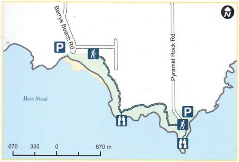
Length/Time: Return - 5km / 2 hours
Difficulty: Moderate
Surface: Gravel, grass and boardwalks with steps
Location: Pyramid Rock Road. Phillip Island
Parking: Pyramid Rock Road (unsealed) and Berrys Beach Road (sealed)
Toilets: Pyramid Rock Road and Berrys Beach Road car parks
Dogs: Dogs are not permitted
21. Scenic Estate Conservation Reserve
Known for its birdlife and habitat for six species of threatened birds, endangered grasslands and vegetation. Walk takes you through native grassland and wetlands. A viewing platform overlooks Churchill Island Marine National Park and the Ramsar wetland.
Length/Time: Return - 2.4km / 40 minutes
Difficulty: Easy
Surface: Fine gravel and boardwalks. Suitable for bikes and prams
Location: Phillip Island Road, Surf Beach, Phillip Island
Parking: Car park (gravel), Boobialla Road, Phillip Island
Dogs: No dogs on foreshore, allowed on leash in other areas
22. Swan Lake Walk
This freshwater lake, situated just before the Penguin Parade entrance, is a significant site for the Bunurong/Boon Wurrung People. It provides great bird watching from the two bird hides near the lake's edge.
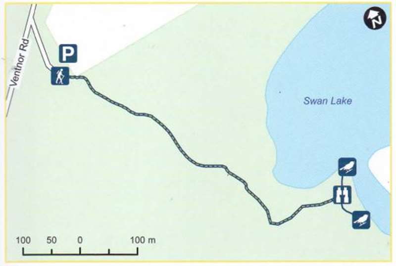
Length/Time: Return -1.3km / 20 minutes
Difficulty: Easy
Surface: Slight undulation from the car park before it joins the boardwalk. Suitable for bikes and prams
Location: Ventnor Road, Summerlands, Phillip Island (just before the Penguin Parade entrance)
Parking: Car park (gravel)
Dogs: Dogs allowed on lead, see signage for season / time restrictions
23. The Nobbies
The Nobbies walk at the western tip of Phillip Island offers spectacular views of Phillip Island's southern coast. The boardwalk takes you to the blowhole and through the breeding colonies of sea birds including the Little Penguins and Silver Gulls.
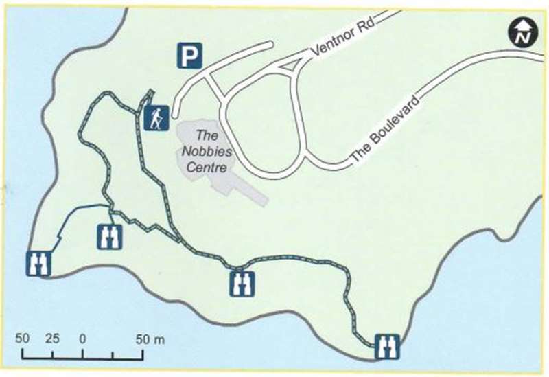
Length/Time: Return - 800m / 20 minutes
Difficulty: Easy, reasonably flat
Surface: Boardwalk around the headland, lower section has steps. Suitable for prams
Location: The Nobbies Centre, 1320 Ventnor Road, Summerlands, Phillip Island
Parking: The Nobbies Centre car park (sealed)
Toilets: Nobbies Centre (inside and outside)
Mobility Access: Suitable for 800m along upper level as there are steps in the lower section of boardwalk
Dogs: Dogs not permitted
Wonthaggi
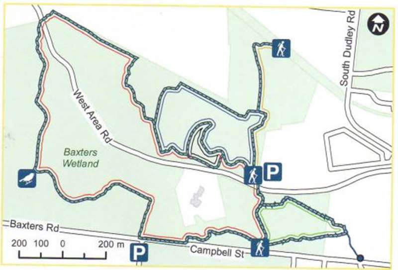
24. Baxters Wetland
A replanting project which takes you past indigenous vegetation to a large wetland area. Good locations for bird observing along the track, as well as from the bird hide. Provides access to view Wonthaggi Wind Farm via the Wetlands track which goes through to Baxters Beach but it's very steep, rough and at times muddy. For more information please refer to the Wonthaggi Heathland & Coastal Reserve brochure.
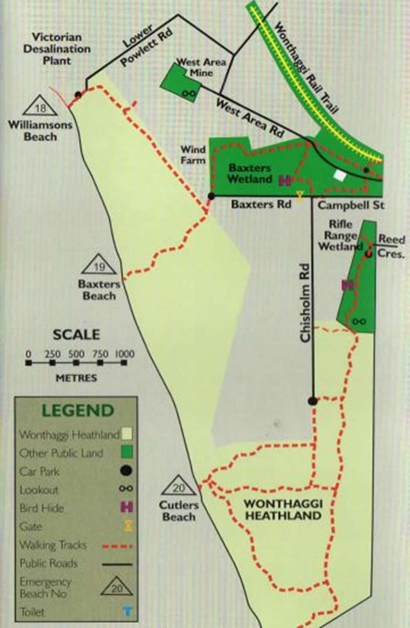
Length/Time: Loop - 5km / 1 1/2 hours (excluding beach tracks)
Difficulty: Easy around the Wetlands with some steep sections
Surface: Mown grass, gravel. dirt and sand.
Location: Intersection of Campbell Street and Chisholm Road, Wonthaggi
Parking: Car parking on grass verge (subject to weather conditions)
Dogs: Dogs allowed on lead
25. State Coal Mine Central Area Walks
There are five walking tracks, each revealing a different aspect of the central mining area while Baxters Loop takes you through heathland, past historic ruins to Baxters Wetland and the bird hide. Tracks are Pioneer Mines Loop Track, Baxters Loop Track, No. 5 Brace Loop Track, Rail Trail Historic Mining Track and Cinder Loop Track.
Length/Time: Total - 4.6km / 1-3 hours
Difficulty: Moderate
Surface: Crushed rock, gravel, mown grass, natural surface and bitumen road
Location: Campbell Street or West Area Road, Wonthaggi
Parking: Unmarked car park (gravel) off West Area Road
Dogs: Dogs allowed on lead
26. Tank Hill Reserve
Track through native bushland around the site of Wonthaggi's first water supply, with parts replanted by volunteers. There are many native birds and a number of small tracks branch off from main loop track. A fire burnt out parts of the Reserve in December 2015.
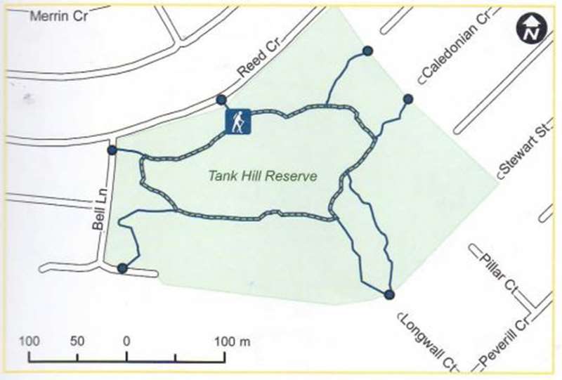
Length/Time: Return - 600m / 10 minutes (main track)
Difficulty: Moderate, narrow uneven track with short steep climbs
Surface: Sand, dirt
Location: Reed Crescent, Wonthaggi
Parking: Parking on the verge in Reed Crescent, Wonthaggi
Dogs: Dogs allowed on lead
27. Victorian Desalination Project Ecological Reserve Trails
There are a number of walks in the 225 hectare ecological reserve surrounding the Desalination Plant. The walks cover natural and restored bushland, wetlands and dunes, and include two viewing decks, a bird hide and picnic area.
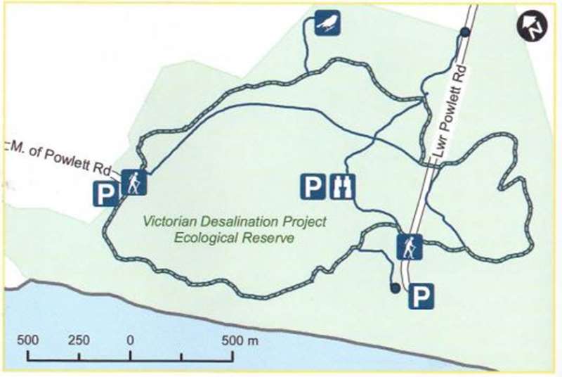
Length/Time: 6-8km / 2-3 hours
Difficulty: Easy with some moderate to difficult undulations depending on the track
Surface: Compacted gravel, boardwalks. Suitable for bikes and prams
Location: Lower Powlett Road, Wonthaggi
Parking: Car park (sealed)
Toilets: Ecological Reserve car park
Horses: Horses permitted
Dogs: Dogs allowed on lead, see signage for season / time restrictions
28. Wonthaggi Bushland Reserve (Shane's Bush)
This reserve has rare natural remnant bushland that has never been cleared and the walk takes you through native vegetation including a Melaleuca Swamp trail.
Length/Time: Loop - 1.2km / 20 minutes
Difficulty: Easy, narrow in sections
Surface: Mown grass
Location: Elizabeth Street or Jean Dennis Road, Wonthaggi
Parking: Elizabeth Street or Jean Dennis Road, Wonthaggi (unsealed)
Dogs: Dogs allowed on lead
29. Wonthaggi East Area Rail Trail
Easy walk takes you through Fincher Street Reserve, crosses Bass Highway and continues on a sheltered path bordered by native vegetation.
Length/Time: Return - 4.4km / 1 hour
Difficulty: Easy
Surface: Compacted granitic sand, bitumen road crossing and gravel. Suitable for bikes and prams
Location: 1 Bent Street, Wonthaggi
Parking: Car park (sealed), Wonthaggi Centennial Centre, Bent Street, Wonthaggi
Toilets: Wonthaggi Centennial Centre
Mobility Access: Suitable for Fincher Street Reserve only (2km return)
Dogs: Dogs allowed on lead, see signage for season / time restrictions
30. Wonthaggi Heathland Nature Conservation Reserve and Kilcunda - Harmers Haven Coastal Reserve
The 811 hectare heathland reserve is bounded by 10 kilometres of unspoiled and secluded coastline. It was formed from old coastal dunes and the developed heathland has been able to sustain a specialised vegetation cover. For more information please refer to the Wonthaggi Heathland & Coastal Reserve brochure.
Length/Time: Loop - 6.7km / 2 hours (main track)
Difficulty: Moderate
Surface: Grass, sand. Suitable for bikes.
Location: Chisholm Road, Wonthaggi
Parking: Car park (gravel), end of Chisholm Road, Wonthaggi
Horses: Horses permitted
Dogs: Dogs allowed on lead
31. Wonthaggi Rifle Range Wetland Reserve
Walk through the wetlands of the rehabilitated former rifle range to The Butts Lookout for panoramic views and birdlife. The Butts is a mound of clay placed behind the targets of the old rifle range (any bullets that missed the targets would generally hit the clay mound). About 200m from the car park the track branches to the right to a bird hide overlooking the wetland. Walkers may continue on from the Butts Lookout to the Wonthaggi Heathland.
Length/Time: Return - 2km / 1 hour (to the Butts Lookout)
Difficulty: Easy
Surface: Grass and compacted gravel
Location: Reed Crescent, Wonthaggi
Parking: Car park (unsealed) in Reed Crescent. Wonthaggi
Dogs: Dogs allowed on lead
31. Wonthaggi Wetlands Reserve
Walk or cycle this scenic boardwalk and track around the Wonthaggi Wetlands, right in the middle of town.
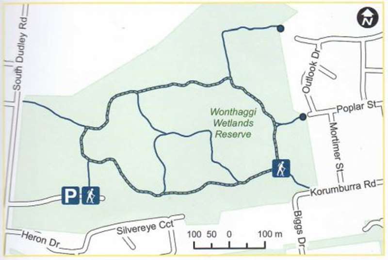
Length/Time: Loop - 2.2km / 45 minutes (including side tracks)
Difficulty: Boardwalk and compacted gravel. Easy, gentle undulations
Surface: Suitable for bikes and prams
Location: South Dudley Road, Outlook Drive or the Corner of Korumburra Road and Biggs Drive, Wonthaggi
Parking: Car park (unsealed) off South Dudley Road (near Heron Drive), Wonthaggi
Toilets: Wonthaggi Plaza. 2 Biggs Drive, Wonthaggi
Dogs: Dogs allowed on lead
Safety Measures
While there are walks for all ages and abilities, please ensure you follow some basic safety measures:
- check weather conditions and be aware of the impact of weather on track surface conditions
- check the fire danger rating and be prepared to change your plans
- if extreme heat is predicted cancel or postpone your activity
- be prepared to turn back if the weather deteriorates
- know your capabilities and choose an appropriate walk
- take water and a charged mobile phone with you
- watch for snakes
- stay on walking tracks and keep clear of steep cliff edges
- wear appropriate clothes, shoes and sunscreen
- for moderate to difficult walks consider telling a responsible person where you are going and when you expect to return
Web Links
→ Bass Coast parks and reserves - Park note (PDF)
→ George Bass Coastal Walk - Park Note (PDF)
→ Bass Coast Walks and Trails
")


")