Ballarat Koorie Heritage Trail

The 40km long Ballarat Koorie Heritage Trail takes you on a journey into the richness of the region's Aboriginal past. The route can be cycled or driven.
The 10 sites featured include the median strip on the corner of Armstrong and Sturt streets near the Ballarat Town Hall; 'Yuille's Station' Park off Vickers Street in Sebastopol; Lake Wendouree, on Wendouree Parade (near the playground); the Koorie Art Poles, located in the Western Bed of Ballarat Botanical Gardens; the Wathaurong Plants Trail; the Reconciliation Mural on the corner of Fussell and Victoria Streets; the former Ballarat Orphanage (Damascus College, near the corner of Stawell and Victoria Streets;), the Black Hill lookout; and the Ballarat and District Aboriginal Cooperative on the corner of Armstrong and Market Streets.
Interpretation boards at each site describe a history that reaches back thousands of years when clans of the Wathaurong roamed the area. The trail reveals a shared local history, one which is inclusive of Aboriginal peoples.
Start at Town Hall, 225 Sturt Street, Ballarat.
Map of Ballarat Koorie Heritage Trail Route
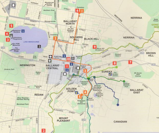
Red markers on the map
1. Town Hall (median strip, Armstrong St & Sturt St intersection)
2. Sebastopol ("Yuilles Station" Park off Vickers St)
3. Lake Wendouree (Wendouree Pde, near playground)
4. Koorie Art Poles (Western bed, Ballarat Botanical Gardens)
5. Wathaurung Plants Trail (North Gardens Wetlands entrance)
6. Frank Wilson's Grave (Ballarat New Cemetery)
7. Reconciliation Mural (Cnr Fussell & Victoria Sts)
8. Ballarat Orphanage - The Stolen Generations (Damascus College, 150m from cnr Stawell & Victoria Sts)
9. Black Hill Lookout
10. Ballarat & District Aboriginal Co-operative (Cnr Armstrong & Market Sts)
Location
225 Sturt Street, Ballarat 3350 Map
")


")