Alto Heritage Walk (Croydon)

.jpg "Alto Heritage Walk (Croydon)")
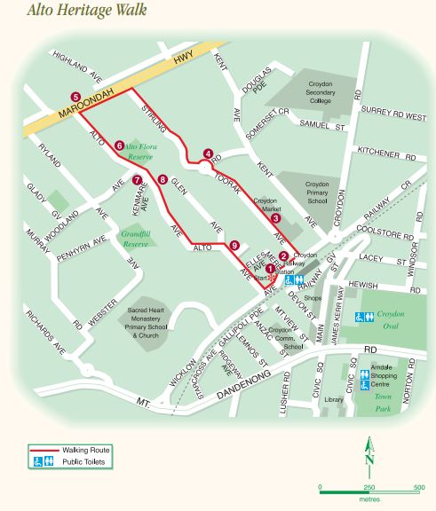
The 2.8 km walk takes in the views of the high-ground of the City of Maroondah and historical elements. It starts at the northern side of Croydon Railway Station.
The route description is:
Start on the northern side of Croydon Railway Station (first called Warrandyte Station when opened in 1882). The surrounding area had been known as White Flats because of the profusion of white wildflowers. Gregory Lacey owned the land around the station and his suggestion that it be called Croydon was later accepted. The name came from the English town where his wife had lived.
1. 67 Wicklow Avenue - This property was originally a guesthouse. Along with holiday-makers, a young returned WW1 soldier, George Holder, enjoyed his evening meals here while he established an orchard over the hill on the main highway. The house was demolished in 1999 and Wicklow Medical Centre occupies the site.
2. The present Anglican Church of Saint John the Divine was built in 1956, replacing a weatherboard church which had been on the site since 1922.
3. Croydon Market commenced trading by Allan Brown in 1927. In earlier days you would hear the sounds of cattle, sheep, pigs, poultry etc. and occasionally see some livestock escape and bolt for freedom. The Coles Supermarket opened in 1982.
4. When George Holder walked up the hill to his orchard, the area was mostly undeveloped, apart from a few scattered orchards. There had been a clay pit in what is now Stirling Road. This had been used by John Looby, who was a brickmaker and the first purchaser of the land in 1873.
At the corner of Stirling Road and Gairns Court there is a small playground.
5. George's orchard was on the far side of the highway. McDonald's, now stands on part of the land. Prior to McDonald's, a drive-in theatre occupied the orchard site. As we continue along Maroondah Highway towards Alto Avenue we move into Kelly Country. In 1889 Richard Kelly purchased 100 acres stretching from the highway over the hill to Mt Dandenong Road beyond the railway line. Each evening he would close his northern gate where Alto Avenue meets the highway. His homestead "Wicklow Hills" was on what is now The Terrace on the southern slope, where he also developed an orchard.
6. Alto Reserve - After climbing to the highest point in the area, take a rest at Alto Reserve and study some of the virgin bush in its untouched state. There is a seat next to the bushland. After this break, cross to the other side of the avenue at number 69.
7. The Grey Sisters Rest Home For Mothers - It is named "Kewn Kreestha" meaning the Quiet of Christ.
8. On your left, overlooking numbers 66-64, look across the Yarra Valley, towards Healesville and the mountain background of the Great Dividing Range in the north-east. Enjoy the view as you continue descending Alto Avenue.
9. The Terrace - where the original Kelly homestead, "Wicklow Hills", once stood. Bushfires were always a hazard and the homestead was burned down in 1928. Continue along Alto Avenue to Wicklow Avenue. Richard Kelly's son, Franklin, made plans for this road through their property, up over the hill to the main highway. He named it Alto Avenue, because of the high altitude. In 1920 he offered 70 allotments reaching from north to south in the Wicklow Hills Estate for sale. Homes began to be built here in the 1920's.
Note: There are no toilets or water tap along the route, although there is a McDonalds across Maroondah Highway near point #5.
Access for Dogs:
Dogs must be on leash.
Photos:
Location
71 Wicklow Avenue, Croydon 3136 View Map
Web Links
→ Alto Heritage Walk Guide and Map (PDF)


")